
You Searched For
« Previous
| 51 - 60 of 60 |
Next »
Search Results
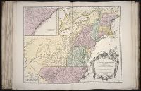
52.

- Creator:
- Haye, G. de la
Robert de Vaugondy, Gilles, 1688-1766, creator - Published / Created:
- 1750
- Call Number:
- 2003 Folio 85
- Image Count:
- 1
- Description:
- BEIN 2003 Folio 85: No. 28 of 45 maps bound together with binder's spine title: Atlas of America; ms. table of contents. Bookplate: Robinson. Bookplate of Paul Mellon., Hand colored., par le Sr. Robert, geographe ordinaire du roy, avec privilege. 1750. Guill. ' Delahaye, sculpsit., Relief shown pictorially., and Scale [ca. 1:5,000,000].
- Subject (Geographic):
- West Indies -- Maps -- Early works to 1800
- Found in:
- Beinecke Rare Book and Manuscript Library > Partie de la mer du Nord: ouse trouvent les grandes et petites isles Antilles, et les isles Lucayes

- Call Number:
- 1973 Folio 67
- Collection Title:
- The West-India pilot: containing piloting directions for Port Royal and Kingston harbours in
- Image Count:
- 1
- Subject (Geographic):
- Atlantic Ocean --Maps --Early works to 1800, Santo Domingo (Dominican Republic) --Maps --Early works to 1800, and West Indies --Maps --Early works to 1800
- Subject (Topic):
- Harbors --Atlantic Coast (North America) --Maps --Early works to 1800, Nautical charts --Atlantic Coast (North America) --Early works to 1800, Nautical charts --Caribbean Area --Early works to 1800, Nautical charts --West Indies --Early works to 1800, Pilot guides --Atlantic Coast (North America) --Early works to 1800, Pilot guides --Caribbean Area --Early works to 1800, and Pilot guides --West Indies --Early works to 1800
- Collection Created:
- London : Printed for the author and sold by S. Hooper ..., MDCCLXXI [1771]
- Found in:
- Beinecke Rare Book and Manuscript Library > Plan de la Rade du Port Paix

- Call Number:
- 1973 Folio 67
- Collection Title:
- The West-India pilot: containing piloting directions for Port Royal and Kingston harbours in
- Image Count:
- 1
- Subject (Geographic):
- Atlantic Ocean --Maps --Early works to 1800, Cap-Francais (Haiti), and West Indies --Maps --Early works to 1800
- Subject (Topic):
- Harbors --Atlantic Coast (North America) --Maps --Early works to 1800, Nautical charts --Atlantic Coast (North America) --Early works to 1800, Nautical charts --Caribbean Area --Early works to 1800, Nautical charts --West Indies --Early works to 1800, Pilot guides --Atlantic Coast (North America) --Early works to 1800, Pilot guides --Caribbean Area --Early works to 1800, and Pilot guides --West Indies --Early works to 1800
- Collection Created:
- London : Printed for the author and sold by S. Hooper ..., MDCCLXXI [1771]
- Found in:
- Beinecke Rare Book and Manuscript Library > Plan du Cap Francois

- Call Number:
- 1973 Folio 67
- Collection Title:
- The West-India pilot: containing piloting directions for Port Royal and Kingston harbours in
- Image Count:
- 1
- Subject (Geographic):
- Atlantic Ocean --Maps --Early works to 1800, Haiti --Maps --Early works to 1800, and West Indies --Maps --Early works to 1800
- Subject (Topic):
- Harbors --Atlantic Coast (North America) --Maps --Early works to 1800, Nautical charts --Atlantic Coast (North America) --Early works to 1800, Nautical charts --Caribbean Area --Early works to 1800, Nautical charts --West Indies --Early works to 1800, Pilot guides --Atlantic Coast (North America) --Early works to 1800, Pilot guides --Caribbean Area --Early works to 1800, and Pilot guides --West Indies --Early works to 1800
- Collection Created:
- London : Printed for the author and sold by S. Hooper ..., MDCCLXXI [1771]
- Found in:
- Beinecke Rare Book and Manuscript Library > Plan du cul de sac de Leogane ou le Port au Prince
56.

- Call Number:
- Taylor 257
- Collection Title:
- Les voyages dv sievr de Champlain Xaintongeois, capitaine ordinaire pour le Roy, en la marine
- Image Count:
- 1
- Description:
- Facing p. 22.
- Subject (Geographic):
- New France --Discovery and exploration
- Subject (Name):
- Pelletier, David
- Subject (Topic):
- Indians of North America --Canada
- Collection Created:
- A Paris : Chez Iean Berjon, rue S. Iean de Beauuais, au Cheual volant, & en sa boutique au Palais, a la gallerie des prisonniers, MDCXIII [1613]. Avec privilege dv Roy
- Found in:
- Beinecke Rare Book and Manuscript Library > Port Royal
57.

- Published / Created:
- 1612
- Call Number:
- Taylor 258
- Collection Title:
- Descriptio ac delineatio geographica detectionis freti, sive, transitus ad occasum supra terras
- Image Count:
- 1
- Abstract:
- Map depicts the Coat of Arms of the United Kingdom (era of the Union of the Crowns), reigning between the years 1603-1707.
- Alternative Title:
- Tabula nautica ...
- Description:
- Bound in after p. [6]., In ink on recto: place names "Okkak", "Nain"[?] and one longer handwritten note on the bottom margin., Map cut and folded irregularly., Map has been repaired with multiple pieces of tape on verso., Map has multiple small stains on both the recto and verso., Printed on recto in lower right corner: A1., and Scale [ca. 1:9,000,000].
- Subject (Geographic):
- North Atlantic Ocean --Maps --Early works to 1800
- Subject (Name):
- Hudson, Henry, d. 1611
- Collection Created:
- Amsterodami Ex officina Hesse lij Gerardi. Anno 1613
- Found in:
- Beinecke Rare Book and Manuscript Library > Tabula nautica, qua repraesentantur orae maritimae, meatus, ac freta, noviter a H. Hudsono Anglo ad Caurum supra Novam Franciam
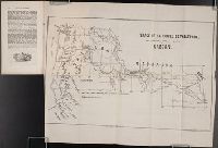
- Creator:
- Society for the Propagation of the Faith
T. Ireland - Published / Created:
- 1851 March
- Call Number:
- Zc13 M6 So3d
- Collection Title:
- Rapport sur les missions du diocese de Quebec [microform]
- Image Count:
- 1
- Subject (Geographic):
- Canada --Church history, Missouri, Oregon --Maps, Walla Walla (Wash.) --Maps, Walla Walla Valley (Or. and Wash.), Washington (State), and Westport (Kansas City, Mo.)
- Subject (Topic):
- Catholic Church --Missions, Indians of North America --Missions --Canada, Missions --Northwest, Pacific, Missions --Oregon, and Missions --Quebec (Province)
- Collection Created:
- Quebec : L. Brousseau, 1839-1874
- Found in:
- Beinecke Rare Book and Manuscript Library > Trace de la route de Westport, Etat de Missouri, a Walla Walla, Oregon
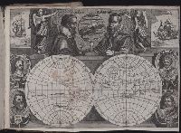
- Published / Created:
- [1618]
- Call Number:
- Taylor 275
- Collection Title:
- Journal ou relation exacte du voyage de Guill Schouten
- Image Count:
- 1
- Description:
- Bound in after p. [8]., Busts of various explorers depicted around edges of map., Four small areas with stains on verso., Scale not given., and Western hemisphere of North and South America hand colored.
- Subject (Topic):
- Oceania --Discovery and exploration --Early works to 1800, Voyages around the world --Early works to 1800, and World maps --Early works to 1800
- Collection Created:
- A Paris : chez M. Gobert, au Palais en la gallerie des prisonniers, et les cartes, chez M. Tauernier, graueur du roy, demeurant au pont Marchand, 1618
- Found in:
- Beinecke Rare Book and Manuscript Library > [Double hemisphere map of the world showing track of Schouten’s voyage in 1615-1617]

- Published / Created:
- 1618?
- Call Number:
- Taylor 278
- Collection Title:
- Jovrnal ou Description dv merveillevx voyage de Gvillavme Schovten, hollandois natif de Hoorn
- Image Count:
- 1
- Description:
- Bound in facing p. 72., Imperfect: Map wormed, with loss of text; repair made on back of map., and Scale not given.
- Subject (Geographic):
- New Guinea --Maps --Early works to 1800
- Subject (Name):
- Schouten, Willem Corneliszoon, d. 1625
- Collection Created:
- A Amstredam : Chez Harman Ianson, marchand libraire, demeurant en la VVarmoes-straet, a le Sereine, 1619
- Found in:
- Beinecke Rare Book and Manuscript Library > [Map of Nova Guinea]