America septentrionalis in suas praecipuas partes divisa, ad usum serenissimi Burgundiae ducis
Description:
Hand col. Sheet measures 53.4 x 61.4 cm. Stamped on verso: Yale, Horace Brown, 1900S., Includes decorative cartouche., Includes six bar scales., Prime meridian: Ferro., Relief shown pictorially., and Watermark.
"86" in upper right corner., Appears in Le Rouge's Atlas nouveau portatif à l'usage des militaires (1748 and 1756 eds.)., Bar scale in "milles Angloises, 60 au degré.", Cross Collection no. 296., Hand col., and Relief shown pictorially.
Publisher:
Ches les Sr. le Rouge,
Subject (Geographic):
Antigua--Maps--Early works to 1800
Subject (Name):
Le Rouge, Georges-Louis. Atlas nouveau portatif à l'usage des militaires
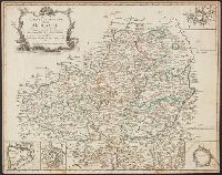
"Avec Privilege du Roi.", Insets: Map of territory west of Lake Superior; map of territory west of Florida; view of "Sault du Niagara, de 135 pieds de haut"., Relief shown pictorially., Second state: contains two keys to colors "Couleur selon les pretentions des Anglois" and "Selon les pretentions de la France.", and Watermark. Manuscript number on verso: XV 256.
Publisher:
[Georges-Louis Le Rouge] Rue des Augustins,
Subject (Geographic):
Atlantic States--Maps--Early works to 1800., France--Colonies--America--Maps--Early works to 1800., Great Britain--Colonies--America--Maps--Early works to 1800., Maritime Provinces--Maps--Early works to 1800., and United States--History--French and Indian War, 1754-1763--Maps--Early works to 1800.
"Avec Privilege du Roi.", Insets: Map of territory west of Lake Superior; map of territory west of Florida; view of "Sault du Niagara, de 135 pieds de haut"., Relief shown pictorially., and Second state: contains two keys to colors "Couleur selon les pretentions des Anglois" and "Selon les pretentions de la France."
Publisher:
[Georges-Louis Le Rouge] Rue des Augustins,
Subject (Geographic):
Atlantic States--Maps--Early works to 1800., France--Colonies--America--Maps--Early works to 1800., Great Britain--Colonies--America--Maps--Early works to 1800., Maritime Provinces--Maps--Early works to 1800., and United States--History--French and Indian War, 1754-1763--Maps--Early works to 1800.