Skip to search
Skip to main content
Skip to first result
Search
You Searched For
Resource Type
Maps, Atlases & Globes
New Search
Search Results
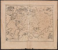
Published / Created:
[1635?]
Call Number:
3331 B47 1635
Container / Volume:
BRBL_00082
Image Count:
2
Resource Type:
Maps, Atlases & Globes
Description:
Preliminary record.
Subject (Geographic):
Beemster (Netherlands)--Maps--Early works to 1800 and North Holland (Netherlands)--Maps--Early works to 1800
Found in:
Beinecke Rare Book and Manuscript Library > Agri Biemstrani descriptio a L.I.S.
Creator:
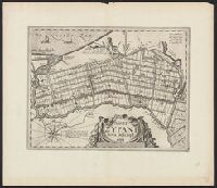
Published / Created:
[1922]
Call Number:
8821 1922
Container / Volume:
BRBL_00653
Image Count:
2
Resource Type:
Maps, Atlases & Globes
Description:
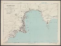
"No. 2.", Accompanied by physiographic plate covering same area, showing only relief and drainage (1 sheet : col. ; 48 cm.)., Appears in Atlas geográfico de la República Mexicana., and Relief shown by shading.
Publisher:
La Dirección,
Subject (Geographic):
Aguascalientes (Mexico : State)--Maps
Subject (Name):
Mexico. Dirección de Estudios Geográficos y Climatológicos. Atlas geográfico de la República Mexicana
Found in:
Beinecke Rare Book and Manuscript Library > Aguascalientes / Secretaría de Agricultura y Fomento, Dirección de Estudios Geográficos y Climatológicos.
Creator:
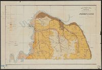
Published / Created:
1943
Call Number:
3897 Aj12 1943
Container / Volume:
BRBL_00184
Image Count:
1
Resource Type:
Maps, Atlases & Globes
Alternative Title:
[G.S.G.S.] ; 4381 and Great Britain. War Office. General Staff. Geographical Section. G.S.G.S. ; 4381.
Description:
"Contours at 10 metres interval.", Important streets and buildings are named., In upper margin: Corsica 1:5,000 ..., and Military grid.
Publisher:
Army Map Service, U.S. Army,
Subject (Geographic):
Ajaccio (France)--Maps
Found in:
Beinecke Rare Book and Manuscript Library > Ajaccio, plan of port [cartographic material] / Drawn by War Office, 1943.
Creator:
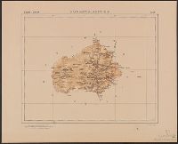
Published / Created:
1942]
Call Number:
344 AK35 1942
Container / Volume:
BRBL_00093
Image Count:
1
Resource Type:
Maps, Atlases & Globes
Description:
"1938.", "IV. 45. KrK uVermA 5.", and Cadastral maps.
Publisher:
Die Abteilung,
Subject (Geographic):
Akershus fylke (Norway)--Maps and Oslo (Norway)--Maps
Found in:
Beinecke Rare Book and Manuscript Library > Aker m = 1:10 000.
Branch:v1.61.8 ,Deployed:2024-06-20T11:15:15-04:00