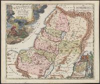
Has watermark., Inset: Populi Isräelitici ex Aegÿpto ... [shows route of the Exodus; Moses and Aaron standing nearby]., Map of Palestine divided among the 12 Tribes, drawn by Homann after Guillaume Sanson. The shoreline runs from Sidon to Rinocorura., and Reli
Publisher:
[Homann,
Subject (Geographic):
Palestine--History--To 70 A.D.--Maps--Early works to 1800 and Palestine--Maps--Early works to 1800
Subject (Name):
Sanson, Guillaume
Subject (Topic):
Bible.--O.T.--Geography--Maps--Early works to 1800
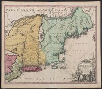
Cf. McCorkle, B.B. New England in early printed maps 1513-1800, no. 724.1., Map features New Jersey, New York and New England., Relief represented pictorially., and Sheet measures 51.5 x 60.4 cm.
Publisher:
[s.n.,
Subject (Geographic):
New England--Maps--Early works to 1800, New Jersey--Maps--Early works to 1800, and New York--Maps--Early works to 1800
Cf. McCorkle, B.B. New England in early printed maps 1513-1800, no. 724.1., Map features New Jersey, New York and New England., Relief represented pictorially., and Sheet measures 53.1 x 64.8 cm. Ms. no. on verso: 226. Cross Collection no. 182.
Publisher:
[s.n.,
Subject (Geographic):
New England--Maps--Early works to 1800, New Jersey--Maps--Early works to 1800, and New York--Maps--Early works to 1800
"Cum privilegio Sac. Caes. Maj.", Map features New Jersey, New York and New England., Relief represented pictorially., and Sheet measures 53.6 x 62.3 cm. Ms. no. on verso: 141. Title in ms. on verso. Franklin Collection no. 131 1759-2.
Publisher:
[s.n.,
Subject (Geographic):
New England--Maps--Early works to 1800, New Jersey--Maps--Early works to 1800, and New York--Maps--Early works to 1800
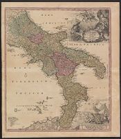
Novissima & exactissima totius regni Neapolis tabula, Novissima & exactissima totius regni Neapolis tabvla, Novissima and exactissima totius regni Neapolis tabula, and Novissima and exactissima totivs regni Neapolis tabvla
Description:
"Cum priv. S.C.M.", Bar scales given in "milliaria Germanica," "milliaria Gallica," and "milliaria Italica.", Copy 2: Ms. number on verso: XXXVIII. Sheet measures 61.9 x 54.4 cm., Includes legend and ill., and Relief shown pictorially.
Publisher:
Johann Baptist Homann,
Subject (Geographic):
Naples (Italy : Province)--Maps--Early works to 1800 and Naples (Kingdom)--Maps--Early works to 1800