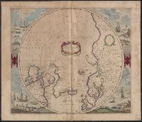
Cross collection no. 48., From: Mercator's Atlas, or, A geographicke description of the regions, countries and kingdoms of the world [1641?], Includes decorative title cartouche, blank dedication cartouche, and four illustrations (colored engravings) of Arctic whaling scenes., Polar projection., and Relief shown pictorially.
Publisher:
Jan Jansson and Hendrik Hondius,
Subject (Geographic):
Arctic Regions--Maps--Early works to 1800, North Pole--Maps--Early works to 1800, and Northern Hemisphere--Maps--Early works to 1800
Subject (Name):
Jansson, Jan, 1588-1664 and Mercator, Gerhard, 1512-1594. Atlas, or, A geographicke description of the regions, countries and kingdomes of the world
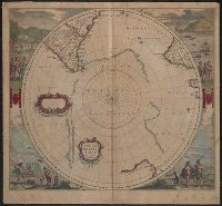
Appears in J. Jansson and H. Hondius' Atlas novus., Includes marginal ill. and title and blank cartouches., Latin text on verso., and Relief shown pictorially.
Publisher:
H. Hondius and J. Jansson,
Subject (Geographic):
Antarctica--Maps--Early works to 1800 and Southern Hemisphere--Maps--Early works to 1800
Subject (Name):
Jansson, Jan, 1588-1664 and Jansson, Jan, 1588-1664. Atlas novus
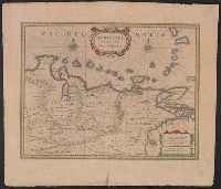
Bar scales in "Milliaria Germanica communia" and "Milliaria Gallica communia.", From Jan Jansson and Henrik Hondius's Atlas novus ... Amstelodami : Apud Ionnem Ianssonium & Henricum Hondium, 1638., In, Relief shown pictorially., and Sheet measures 50.9 x 58.3 cm.
Publisher:
Henricus Hondius excudit,
Subject (Geographic):
Venezuela--Maps--Early works to 1800
Subject (Name):
Hondius, Hendrik, 1597-1651. Atlas novus and Jansson, Jan, 1588-1664. Atlas novus