Skip to search
Skip to main content
Skip to first result
Search
You Searched For
Resource Type
Maps, Atlases & Globes
Creator
G.W. Bacon & Co
Publication Place
London :
New Search
Search Results
Creator:
Published / Created:
1900
Call Number:
642 1900
Container / Volume:
BRBL_00339
Image Count:
1
Resource Type:
Maps, Atlases & Globes
Alternative Title:
Bacon's large-print map of the Boer Republics, Cape Colony, Natal, &c. and Large-print map of South Africa
Description:
Covers Africa south of Bulawayo., Insets: Durban & Port Natal -- Laing's Nek & vicinity -- Mafeking to Pretoria., and Relief shown by hachures and spot heights.
Publisher:
G.W. Bacon & Co.,
Subject (Geographic):
Africa, Southern--Maps
Found in:
Beinecke Rare Book and Manuscript Library > Bacon's large-print map of South Africa.
Creator:
Published / Created:
[ca. 1917]
Call Number:
307hc 1917
Container / Volume:
BRBL_00036A
Image Count:
2
Resource Type:
Maps, Atlases & Globes
Description:
Relief shown by hachures. and Shows: international boundaries, railways, roads, naval stations, fortified towns, sea routes.
Publisher:
G.W. Bacon & Co.,
Subject (Geographic):
Europe--Maps and Europe--Politics and government--Maps
Subject (Topic):
World War, 1914-1918--Belgium--Maps, World War, 1914-1918--France--Maps, and World War, 1914-1918--North Sea--Maps
Found in:
Beinecke Rare Book and Manuscript Library > Bacon's map of the seat of war in the North Sea, Belgium and eastern France.
Creator:
Published / Created:
[1876?]
Call Number:
32 L84 1876A
Container / Volume:
BRBL_00051
Image Count:
1
Resource Type:
Maps, Atlases & Globes
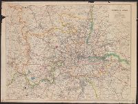
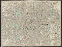
Alternative Title:
Bacon's new shilling map of London and illustrated guide. and Strangers' guide to London.
Description:
Shows radial distances from Charing Cross.
Publisher:
G.W. Bacon & Co.,
Subject (Geographic):
London (England)--Guidebooks and London (England)--Maps
Found in:
Beinecke Rare Book and Manuscript Library > Bacon's new map of London : divided into half mile squares & circles.
Creator:
Published / Created:
[1864?]
Call Number:
75 1864C
Container / Volume:
BRBL_00403
Image Count:
1
Resource Type:
Maps, Atlases & Globes
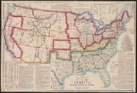
Alternative Title:
Bacon's new steel-plate map of America.
Description:
Hand colored boundaries., Includes notes on the positions of the American forts, the population of the U.S., record of important events of the [U.S. Civil] War, and other information., Inset: England and Wales on the same scale., Pr, and Relief shown by hachures.
Publisher:
Bacon & Co.,
Subject (Geographic):
United States--History--Civil War, 1861-1865--Maps
Found in:
Beinecke Rare Book and Manuscript Library > Bacon's steel plate map of America : political, historical & military.
Branch:v1.61.6 ,Deployed:2024-06-12T09:55:37-04:00