Evans, F. J. (Frederick J.) Great Britain. Hydrographic Dept J. & C. Walker (Firm) Potter, J. D. (John D.) Washington Capt
Published / Created:
Decr. 12th 1860.
Call Number:
26cea 1860
Container / Volume:
BRBL_00023
Image Count:
1
Resource Type:
Maps, Atlases & Globes
Alternative Title:
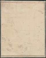
Coral Sea and Great Barrier Reefs shewing the inner and outer routes to Torres Strait
Description:
"2764"., Imperfect: Mutilated with loss of tex, Nautical chart of the Great Barrier Reef and the Coral Sea showing routes to the Torres Strait. Relief is shown by hachures and spot heights. Depth shown by bathymetric soundings., and On verso: XXVIII.
Publisher:
Published at the Admiralty ... under the superintendence of Captn. Washington R.N., F.R.S. Hydrographer ; Sold by J.D. Potter, agent for the Admiralty charts, 31 Poultry and 11 King Street, Tower Hill,
Subject (Geographic):
Coral Sea--Maps and Great Barrier Reef (Qld.)--Maps
Dayman, J. M Great Britain. Hydrographic Dept J. & C. Walker (Firm) Obree, W. H Potter, J. D. (John D.) Simpson, H. G Stanley, Owen, 1811-1850 Yule, C. B
Published / Created:
June 1st, 1855 [i.e. 1911?]
Call Number:
261cea T636 1855
Container / Volume:
BRBL_00022
Image Count:
1
Resource Type:
Maps, Atlases & Globes
Alternative Title:
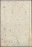
Torres Strait, western channels
Description:
"2375"--Bottom right corner below neat line., "Small corrections I.8, Chart of western channels of Torres Strait, with relief shown by soundings, hachures and spot heights. Vegetation is shown pictorially., and Traditional place names are also given for islands.
Publisher:
Published according to Act of Parliament at the Hydrographic Office of the Admiralty : and Sold by J.D. Potter, agent for the Admiralty charts, 31 Poultry and 11 King Street, Tower Hill,
Davidson, George, 1825-1911. asn CU-BANC Great Britain. Hydrographic Dept J. & C. Walker (Firm)
Published / Created:
[1856?-186-?]
Call Number:
23cea 1856
Collection Title:
Pacific Ocean / Hydrographic Office ; Engraved by J. & C. Walker.
Container / Volume:
BRBL_00021
Image Count:
1
Resource Type:
Maps, Atlases & Globes
Alternative Title:
[Nautical chart] ; no. 2464 and Great Britain. Hydrographic Dept. Nautical chart ; no. 2464.
Description:
1. Kamchatka to Chusan Islands. -- 2. Behring Strait to 30⁰N. lat. -- 3. Cook River, Each sheet includes diagram showing sheet arrangement., Light houses added by hand in color., Relief shown by hachures and spot heights., and Shows lines of magnetic declination.
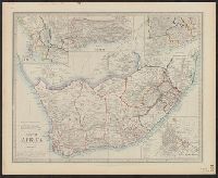
"Compiled from the ms. maps in the Colonial Office, Capt'n. Owen's survey, &c.", In bottom margin: 125., In lower right corner, printed vertically: 105., Insets: Environs of the Cape -- District of George -- Environs of Graham-Town -- Cape-Town., and Relief shown
Publisher:
E. Stanford,
Subject (Geographic):
South Africa--Maps
Subject (Name):
Owen, W. F. W., 1774-1857 and Stanford, Edward, 1827-1904
Subject (Topic):
Military bases, Foreign--South Africa--Maps and Railroads--South Africa--History--Maps