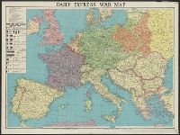
Daily express (London, England) and Daily Express war map of Europe
Description:
Prime meridian: Greenwich. and Wall map of wartime Europe showing beligerent countries (United Kingdom, France, Poland, Germany, Danzig, Soviet Russia), neutral countries, the Maginot Line, the Siegfried Line and European wartime resources.
Publisher:
Printed in Great Britain by George Philip & Son,
Subject (Geographic):
Europe--Maps, Maginot Line (France)--Maps, and Siegfried Line (Germany)--Maps
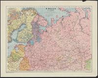
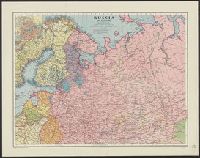
Daily telegraph (London, England), Daily Telegraph war map ; no. 6, Daily Telegraph war map ; no. 6., and War map of the Russian Front
Description:
"Specially prepared for the Daily Telegraph by the London Geographical Institute.", Also shown oil-fields, oil pipe lines, naval bases, railways, canals, and shipping routes., and Wall map showing territories of United Kingdom and "British Empire, Soviet Russia
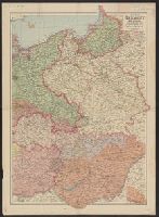
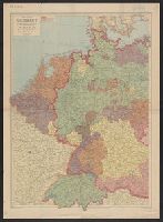
Western Germany, with Holland, Belgium and Switzerland.
Description:
"Sizer"--Autograph in upper lef, Complements Western Germany, with Holland, Belgium and Switzerland., In lower right margin: The London Geographical Institute., Inset: Continuation of Ruthenia on the same scale., and Relief shown by spot heights.
Publisher:
George Philip and Son,
Subject (Geographic):
Europe, Eastern--Maps, Germany--Maps, and Hungary--Maps
In lower right corner of margin: The London Geographical Institute., Insets: Leningrad. Scale 1:100,000 -- Baghdad to the Persian Gulf. Scale 1:4,500,000., and North Sheet -- South Sheet.
In lower right corner of margin: The London Geographical Institute., Insets: Leningrad. Scale 1:100,000 -- Baghdad to the Persian Gulf. Scale 1:4,500,000., and North Sheet -- South Sheet.