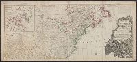
Accompanied by the author's: A topographical description of such parts of North America as are contained in the (annexed) map of the middle British colonies, &c. in North America. vi, 46, 16 p., Includes text, list of townships, distance charts, and inset "A sketch of the remaining part of Ohio R. &c.", Prime meridian: London and Philadelphia., Relief shown pictorially., and Without accompanying text.
Publisher:
Printed & published ... for J. Almon,
Subject (Geographic):
North America--Maps--Early works to 1800 and Northeastern States--Maps--Early works to 1800.
Subject (Name):
Almon, John, 1737-1805, Evans, Lewis, 1700?-1756, and Turner, James, -1759
Accompanied by the author's: A topographical description of such parts of North America as are contained in the (annexed) map of the middle British colonies, &c. in North America. vi, 46, 16 p. and Includes text, list of townships, distance charts, and inset
Publisher:
Printed & published ... for J. Almon,
Subject (Geographic):
America, Canada--Maps--Early works to 1800, East (U.S.)--Maps--Early works to 1800, and Northeastern States--Maps--Early works to 1800.
Subject (Name):
Almon, John, 1737-1805, Evans, Lewis, 1700?-1756, and Turner, James, -1759
Accompanied by the author's: A topographical description of such parts of North America as are contained in the (annexed) map of the middle British colonies, &c. in North America. vi, 46, 16 p., Includes text, list of townships, distance charts, and inset "A sketch of the remaining part of Ohio R. &c.", Prime meridian: London and Philadelphia., Relief shown pictorially., and Without accompanying text.
Publisher:
Printed & published ... for J. Almon,
Subject (Geographic):
North America--Maps--Early works to 1800 and Northeastern States--Maps--Early works to 1800.
Subject (Name):
Almon, John, 1737-1805, Evans, Lewis, 1700?-1756, and Turner, James, -1759
Includes historical notes, insets of "A particular map of Baffin and Hudson's Bay" and "The passage by land to California," and articles 4-7, 9, 12, 13, and 20 of the "definitive treaty.", Prime meridian: London and Ferro., Relief shown pictorially., and Stamped
Date in printer statement, in lower right margin: 15th July 1779., Includes notes and insets of "A particular map of Baffin and Hudson's Bay" and "The passage by land to California ....", Prime meridian: London and Ferro., and Relief shown pictorially.
Insets: A particular map of Baffin and Hudson's Bay -- The passage by land to California., Prime meridians: London and Ferro., Relief shown pictorially., and Yale's copy 1 joined on 2 sheets, 54 x 121 cm. and 54 x 120 cm.; coloring differs from copy 2; and stamp
Publisher:
Published by Laurie & Whittle, No. 53 Fleet Street,
From Thomas Jeffery's American atlas. 1778., Imperfect: southern portion of text torn along fold and separated. Sheets pasted together to form one map. No. "17" stamped on verso, upper right corner., Insets: A chart of the mouth of Hudson's River, from Sandy Hook to New York.--A plan of the city of New York.--Plan of Amboy, with its environs, from an actual survey., Prime meridian: London., Relief shown pictorially., Shows administrative divisions., and Watermarks.
Publisher:
Printed for Robt. Sayer & John Bennett ...,
Subject (Geographic):
New Jersey--Administrative and political divisions--Maps--Early works to 1800., New Jersey--Maps--Early works to 1800., New York (N.Y.)--Maps--Early works to 1800, New York (State)--Administrative and political divisions--Maps--Early works to 1800., Northeastern States, Northeastern States--Maps--Early works to 1800., Perth Amboy (N.J.)--Maps--Early works to 1800., and Québec (Province)--Maps--Early works to 1800
Subject (Name):
Holland, Samuel, 1728-1801 and Robert Sayer and John Bennett (Firm)