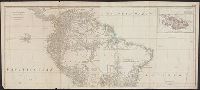
Also appeared in Kitchin's General atlas describing the whole universe. London : Printed for Robert Sayer, [1780]., Includes descriptive notes and text "Division of South America with a summary account of its trade," and large ornamental cartouche., Inset map: Chart of the Falkland's Islands : named by the French Malouine Islands, and discovered by Hawkins in the year 1595. Scale [ca. 1:2,000,000]., Prime meridian: Ferro., Relief shown pictorially; depths by soundings., Sheets measures 54 x 122.7 cm., and Sheets mounted together to form 2 sheets.
Publisher:
Printed for Robert Sayer,
Subject (Geographic):
Falkland Islands--Maps--Early works to 1800 and South America--Maps--Early works to 1800
Subject (Name):
Anville, Jean Baptiste Bourguignon d', 1697-1782, Kitchin, Thomas, d. 1784, and Kitchin, Thomas, d. 1784. General atlas describing the whole universe
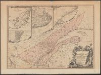
Includes insets of "A particular survey of the Isles of Montreal" and "Course of the river St. Laurence, from La Valterie to Quebec," and indexed insets of "The city of Quebec" and "Plan of Montreal, or Víllemarie.", Relief shown pictorially., and Stamp of Wil
Publisher:
Printed for Robert Sayer, no. 53 Fleet Street,
Subject (Geographic):
Québec (Province)--Maps--Early works to 1800
Subject (Name):
Carver, Jonathan, 1710-1780 and Morse, William Inglis,--b. 1874--Stamp
Bar scales given in "great French leagues," "common French leagues," and "British miles"., Prime meridian: Paris., Relief shown pictorially., Sheet measures 55.6 x 73.6 cm. No. 16 of 34 maps bound together., and Watermark.
Publisher:
Printed for Robert Sayer,
Subject (Geographic):
France--Administrative and political divisions--Maps--Early works to 1800 and France--Maps--Early works to 1800
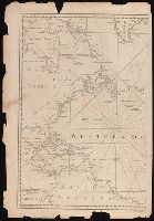
Also shows anchorages, currents, and routes of navigation along the coast., Includes historical notes, text, 10 insets of harbors, and a table showing that "North America is divided into the continent & the islands" according to geography and politics., and Rel
Publisher:
Printed for Robt. Sayer,
Subject (Geographic):
North America--Maps--Early works to 1800
Subject (Name):
Anville, Jean Baptiste Bourguignon d', 1697-1782 and Robert de Vaugondy, Didier, 1723-1786
Kitchin, Thomas, d. 1784 Kitchin, Thomas, d. 1784. General atlas describing the whole universe Sayer, Robert, 1725-1794
Published / Created:
January 1st, 1787.
Call Number:
356 1787
Container / Volume:
BRBL_00114
Image Count:
1
Resource Type:
Maps, Atlases & Globes
Description:
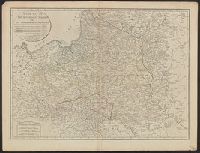
Also appeared in Kitchin's General atlas describing the whole universe. London : Printed for Robert Sayer, [1780]., Relief shown pictorially., Sheet measures 54 x 70.7 cm., and Shows vegetation, marshes, etc.
Publisher:
Robert Sayer,
Subject (Geographic):
Europe, Eastern--Maps--Early works to 1800, Lithuania--Boundaries--Maps--Early works to 1800, Lithuania--Maps--Early works to 1800, Poland--Boundaries--Maps--Early works to 1800, and Poland--Maps--Early works to 180