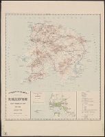
Hand col. Sheet measures 54 x 63 cm. Lada-Mocarski collection., Index to points of interest, and col. illus. of "Crohn Schlot oder Cron Schloss.", and Inset map: "Charte des Neva-Stroms von der Ladogisthen biss in die Ost-See allwo St. Petersburg ... "
Publisher:
Ioh. Baptist Homann,
Subject (Geographic):
Neva River (Russia)--Maps--Early works to 1800 and Saint Petersburg (Russia)--Maps--Early works to 1800
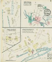
Sanborn fire insurance maps are a rich source of historic data on the urban built environment of North America during the 19th and early 20th centuries. The atlases were created for the purpose of underwriting fire insurance policies, which depended upon accurate and frequently-updated information about construction materials, municipal and transportation infrastructure, industrial and commercial landuse and more. The Yale University Library Map Department scanned its holdings of Sanborn fire insurance maps (consisting primarily of Connecticut towns) in order to make the maps more accessible.
Alternative Title:
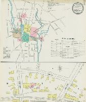
May 1884 Torrington, Conn.
Description:
"3 sheets.", Contains information on population, prevailing winds, water facilities and fire department., Partial cadastral map., and SMLMAPL 766 T63 1884: Sheets disbound. "Triplicate" stamp on sheet. Library of Congress copyright stamp on title sheet.
Subject (Geographic):
Torrington (Conn.)--Maps
Subject (Name):
Library of Congress Stamp
Subject (Topic):
Fire risk assessment--Connecticut--Torrington--Maps and Real property--Connecticut--Torrington--Maps
Sanborn fire insurance maps are a rich source of historic data on the urban built environment of North America during the 19th and early 20th centuries. The atlases were created for the purpose of underwriting fire insurance policies, which depended upon accurate and frequently-updated information about construction materials, municipal and transportation infrastructure, industrial and commercial landuse and more. The Yale University Library Map Department scanned its holdings of Sanborn fire insurance maps (consisting primarily of Connecticut towns) in order to make the maps more accessible.
Alternative Title:
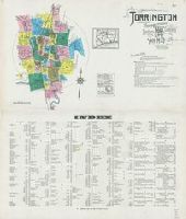
Oct. 1891 Torrington, Conn.
Description:
"(4779) 7 sheets.", Contains information on population, prevailing winds, water facilities and fire department., Includes index of streets and specials., Partial cadastral map., and SMLMAPL 766 T63 1891: Sheets disbound. "Triplicate" stamp on sheet. Library of Congress copyright stamp on title sheet.
Subject (Geographic):
Torrington (Conn.)--Maps
Subject (Name):
Library of Congress Stamp
Subject (Topic):
Fire risk assessment--Connecticut--Torrington--Maps and Real property--Connecticut--Torrington--Maps
Sanborn fire insurance maps are a rich source of historic data on the urban built environment of North America during the 19th and early 20th centuries. The atlases were created for the purpose of underwriting fire insurance policies, which depended upon accurate and frequently-updated information about construction materials, municipal and transportation infrastructure, industrial and commercial landuse and more. The Yale University Library Map Department scanned its holdings of Sanborn fire insurance maps (consisting primarily of Connecticut towns) in order to make the maps more accessible.
Alternative Title:
Sep. 1896 Torrington, Conn.
Description:
"9 sheets 752.", Contains information on population, prevailing winds, water facilities and fire department., Includes index of streets and specials., Partial cadastral map., and SMLMAPL 766 T63 1896: Sheets disbound. "Triplicate" stamp on sheet. Library of Congress copyright stamp on title sheet.
Subject (Geographic):
Torrington (Conn.)--Maps
Subject (Name):
Library of Congress Stamp
Subject (Topic):
Fire risk assessment--Connecticut--Torrington--Maps and Real property--Connecticut--Torrington--Maps
Sanborn fire insurance maps are a rich source of historic data on the urban built environment of North America during the 19th and early 20th centuries. The atlases were created for the purpose of underwriting fire insurance policies, which depended upon accurate and frequently-updated information about construction materials, municipal and transportation infrastructure, industrial and commercial landuse and more. The Yale University Library Map Department scanned its holdings of Sanborn fire insurance maps (consisting primarily of Connecticut towns) in order to make the maps more accessible.
Alternative Title:
Aug. 1924, Torrington, Conn.
Description:
"36 sheets. (1759).", Contains information on population, prevailing winds, water facilities and fire department., Includes index of streets and specials., Partial cadastral map., Sheets 2-16 and 18-22 at scale 1:600; sheets 17 and 23-36 at scale 1:1,200., and SMLMAPL 766 T63 1924: Sheets disbound. Library of Congress copyright stamp on title sheet.
Subject (Geographic):
Torrington (Conn.)--Maps
Subject (Name):
Library of Congress Stamp
Subject (Topic):
Fire risk assessment--Connecticut--Torrington--Maps and Real property--Connecticut--Torrington--Maps