Skip to search
Skip to main content
Skip to first result
Search
You Searched For
Format
cartographic
Genre
Engravings
New Search
Search Results
Creator:
Published / Created:
[1732]
Call Number:
E1015 M66 1732
Collection Title:
Atlas minor: or a set of sixty-two new and correct maps, of all parts of the world. All composed
Image Count:
1
Description:
Autograph of Gravely. Autograph of Baldock. Autograph of Aston. Autograph of W. Alington.
Subject (Geographic):
America--Maps--Early works to 1800
Subject (Topic):
Atlases--Early works to 1800
Collection Created:
London :
Found in:
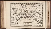
Beinecke Rare Book and Manuscript Library > Florida called by ye French Louisiana & c. By H. Moll geographer.
Call Number:
Taylor 192 1-3
Collection Title:
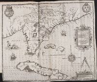
Brevis narratio eorvm qvae in Florida Americae provicia Gallis acciderunt, secunda in illam
Container / Volume:
Pt. 2
Image Count:
1
Description:
Following title page for Part 2.
Subject (Geographic):
Florida --Description and travel and Florida --History --Huguenot colony, 1562-1565
Subject (Name):
Le Moyne de Morgues, Jacques, d. 1588. Brevis narratio
Subject (Topic):
Indians of North America --Florida
Collection Created:
Francoforti ad Moenvm, Typis I. Wecheli, sumtibus vero T. de Bry, venales reperiuntur in officina S. Feierabedii, 1591
Found in:
Beinecke Rare Book and Manuscript Library > Floridae Americae Provinciae
Creator:
Published / Created:
1720?
Call Number:
1975 Folio 31
Collection Title:
[Atlas factice of 42 maps, produced by the Homann Erben firm]
Image Count:
1
Publisher:
Johann Baptist Homann
Subject (Geographic):
Balkan Peninsula --Maps --Early works to 1800
Subject (Topic):
Atlases, German --Early works to 1800
Collection Created:
[Nuremberg,
Found in:
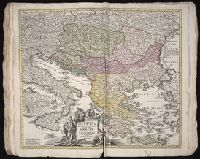
Beinecke Rare Book and Manuscript Library > Fluviorum in Europa principis Danubii [cartographic material] : cum adiacentibus regnis nec non totius Graeciae et archipelagi novissima tabula / authore Joh. Baptista Homanno
Creator:
Published / Created:
1720?
Call Number:
1973 Folio 30
Collection Title:
[Atlas factice of 32 maps and 1 distance table, produced by the Homann Erben firm]
Image Count:
2
Publisher:
Johann Baptist Homann
Subject (Geographic):
Balkan Peninsula --Maps --Early works to 1800
Subject (Topic):
Atlases, German --Early works to 1800
Collection Created:
[Nuremberg : s.n., 1701-1760]
Found in:
Beinecke Rare Book and Manuscript Library > Fluviorum in Europa principis Danubii [cartographic material] : cum adiacentibus regnis nec non totius Graeciae et archipelagi novissima tabula / authore Joh. Baptista Homanno
Creator:
Published / Created:
[ca. 1814]
Call Number:
Zc10 814Le
Collection Title:
History of the expedition under the command of Captains Lewis and Clark, to the sources of the
Image Count:
1
Resource Type:
Maps, Atlases & Globes
Subject (Geographic):
Missouri River. and West (U.S.)
Subject (Topic):
Lewis and Clark Expedition (1804-1806)
Collection Created:
Philadelphia : Bradford & Inskeep ; New York : A.H. Inskeep : J. Maxwell, Printer, 1814
Found in:
Beinecke Rare Book and Manuscript Library > Fortification
Creator:
Published / Created:
[ca. 1814]
Call Number:
Zc10 814Le
Collection Title:
History of the expedition under the command of Captains Lewis and Clark, to the sources of the
Image Count:
1
Resource Type:
Maps, Atlases & Globes
Description:
Between p. 62-63.
Subject (Geographic):
Missouri River. and West (U.S.)
Subject (Topic):
Lewis and Clark Expedition (1804-1806)
Collection Created:
Philadelphia : Bradford & Inskeep ; New York : A.H. Inskeep : J. Maxwell, Printer, 1814
Found in:
Beinecke Rare Book and Manuscript Library > Fortification
Published / Created:
Undated
Call Number:
Taylor 229
Collection Title:
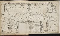
Neuwe Schiffart / warhafftige vnd eygentliche Beschreibung der langwirigen / soerglichen vnd
Image Count:
1
Abstract:
Map of the Strait of Magellan also depicts native people and animals.
Description:
Bound in after p. 4. and Scale not given.
Subject (Geographic):
Magellan, Strait of (Chile and Argentina) --Maps --Early works to 1800
Collection Created:
Gedruckt zu Franckfurt / Durch Matthaeum Becker, 1602
Found in:
Beinecke Rare Book and Manuscript Library > Fretum Magellannicum ...
Creator:
Published / Created:
[ca. 1660]
Call Number:
1983 Folio 19
Collection Title:
[Atlas factice of 96 maps by Blaeu, Visscher, Jansson, Hondius and others]
Image Count:
2
Alternative Title:
Armenia Maior and Asia et Armenia Minor
Description:
Imperfect: illustrations at top cut-out and replaced with ms. titles "Asia et Armenia minor" (upper left) and "Armenia minor" (in upper right); torn along fold and at left edge, with some loss of text. Sheet measures 32 x 47.8 cm. Reinforced along edges with printed waste. No. 85 of 92 maps bound together. and Numbered 91 on verso.
Publisher:
[Nicolaes Visscher]
Subject (Geographic):
Armenia --Maps --Early works to 1800, Assyria --Maps, Egypt --Maps --Early works to 1800, Middle east --Maps --Early works to 1800, Palestine --Geography --Maps --Early works to 1800, Saudi Arabia --Maps, Syria --Maps, and Turkey --Maps
Subject (Name):
Bible --Geography --Maps --Early works to 1800
Subject (Topic):
Atlases --Early works to 1800
Found in:
Beinecke Rare Book and Manuscript Library > Gelegentheyt van't Paradys ende t'Landt Canaan, mitsgaders de eerst bewoonde Landen der Patriarchen, uyt de H. Schristure en verscheyden auctoren by een gestdlt / door Nicolaes Visscher ; A. Broeck sculpsit.
Creator:
Published / Created:
ca. 1684
Call Number:
Folio 469
Collection Title:
[Atlas factice of 13 maps by Nicolaes Visscher I, Nicolaes Visscher II, Guillaume Sanson, and
Image Count:
1
Publisher:
Nicolaes Visscher
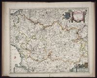
Subject (Geographic):
Artois (France) --Maps --Early works to 1800, Europe --Maps --Early works to 1800, and Pas-de-Calais (France) --Maps --Early works to 1800
Subject (Topic):
Atlases, Dutch --Early works to 1800
Found in:
Beinecke Rare Book and Manuscript Library > Geographica Artesiae comitatus tabula / [cartographic material] / per Nicolaum Visscher edita
Published / Created:
Undated
Call Number:
1976 1233
Collection Title:
Twenty four new and accurate maps of the several parts of Europe ... : all (except the last) new
Image Count:
1
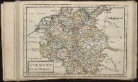
Alternative Title:
Germany in general
Description:
In pencil on verso: 7.
Subject (Geographic):
Germany --Maps --Early works to 1800
Subject (Name):
Barker, B. (Benjamin), d. 1764, bookseller, Clements, Henry, d. 1719, bookseller, King, Charles, d. 1735, bookseller, Nicholson, John, d. ca. 1717, bookseller, Parker, Richard, fl. 1692-1725, bookseller, and Tooke, Benjamin, d. 1716, bookseller
Subject (Topic):
Atlases --Early works to 1800
Collection Created:
[London] : Sold by J. Nicholson at the King’s-Arms in Little Britain, Benj. Barker and Charles King ..., Benj. Tooke ..., Hen. Clements ..., R. Parker and Ralph Smith under the Royal-Exchange ..., [1715?]
Found in:
Beinecke Rare Book and Manuscript Library > Germany
Branch:v1.61.6 ,Deployed:2024-06-12T09:55:31-04:00