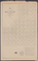
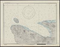
Peirce, Benjamin, 1809-1880 United States Coast Survey
Published / Created:
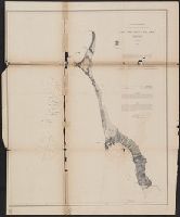
1869
Call Number:
846cea Or4 1869
Container / Volume:
BRBL_00623
Image Count:
1
Resource Type:
Maps, Atlases & Globes
Description:
In upper left margin: No. 16., Includes notes., Relief shown by hachures. Depths shown by soundings., and Removed from: United States Coast Survey, Annual report of the superintendent of the Coast Survey (1869).
Publisher:
U.S. Coast Survey,
Subject (Geographic):
Blanco, Cape (Or.)--Maps and Port Orford (Or.)--Maps
Subject (Name):
United States Coast Survey. Annual report of the superintendent of the Coast Survey. 1869
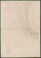
"482.", "Date of publication July 1898.", "To accompany report of Major General Commanding for 1898" outside lower margin., Includes compass rose., and Relief shown by hachures. Depths shown by soundings and isolines.
"Plate No. 1446.", Also shows tide rips, direction and strength of currents, and shoals on George's Bank and Cashe's Ledge., and Depths shown by soundings, isolines, form lines, and shading.
Publisher:
The Survey,
Subject (Geographic):
Maine, Gulf of--Maps and North Atlantic Ocean--Maps
Subject (Topic):
Nautical charts--Maine, Gulf of and Nautical charts--North Atlantic Ocean
[Maury map collection ; Series A5], South Pacific, Wind and current chart of the South Pacific, and Wind and current chart, South Pacific
Description:
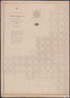
"[Engraved by] Oliver J. Stuart. N.Y."--Sheet 8, lower right margin., "Eng. by Sherman & Smith N.Y."--Sheet 10, lower right margin., Shows prevailing wind direction by month., and Similar wind and current charts of other oceans compiled from materials in the Bur
Publisher:
United States Hydrographical Office,
Subject (Geographic):
South Pacific Ocean--Charts, diagrams, etc
Subject (Name):
Gibbon, Lardner, Maury, Matthew Fontaine, 1806-1873. Wind and current charts, Sherman & Smith, Stuart, Oliver J, United States Naval Observatory, United States. Bureau of Ordnance and Hydrography, United States. Hydrographic Office, and Wells, C. H
[Maury map collection ; Series A5], South Pacific, Wind and current chart of the South Pacific, and Wind and current chart, South Pacific
Description:
"[Engraved by] Oliver J. Stuart. N.Y."--Sheet 8, lower right margin., "Eng. by Sherman & Smith N.Y."--Sheet 10, lower right margin., DLC, Includes, Shows prevailing wind direction by month., and Various eds. of some sheets with updated and additional information.
Publisher:
United States Hydrographical Office,
Subject (Geographic):
South Pacific Ocean--Charts, diagrams, etc
Subject (Name):
Gibbon, Lardner, Maury, Matthew Fontaine, 1806-1873. Wind and current charts, Sherman & Smith, Stuart, Oliver J, United States Naval Observatory, United States. Bureau of Ordnance and Hydrography, United States. Hydrographic Office, and Wells, C. H
[Maury map collection ; Series A3], Indian Ocean, and Wind and current chart, Indian Ocean
Description:
"Drawn by R.H. Wyman & G. B. Balsh, lieutenants, U.S. , April 1854"--Sheet 5, lower margin., "Series A.", and Copy imperfect: All sheets fold lined, with some tears along fold-line. Sheets 5-11discoloration throughout. Sheet 5 torn and repaired in lower right c
Publisher:
United States Hydrographical Office,
Subject (Geographic):
Indian Ocean--Maps
Subject (Name):
Balsh, G. B, Johnson, A. W, Maury, Matthew Fontaine, 1806-1873. Wind and current charts, United States. Hydrographic Office, Wells, C. H, Welsh, George P., -1860, and Wyman, R. H. (Robert Harris), 1822-1882
"Series C." and The pilot charts were released as series C of Maury's "Wind and current charts", series A-F. These charts were designed for sailing ships and recorded wind direction observations made by mariners on previous voyages. For complete discussion, s
Publisher:
United States Hydrographical Office,
Subject (Geographic):
North Atlantic Ocean--Maps
Subject (Name):
Brooke, John M. (John Mercer), 1826-1906, McClelland, D, United States. Bureau of Ordnance and Hydrography, and United States. Hydrographic Office
Subject (Topic):
Nautical charts--North Atlantic Ocean and Winds--North Atlantic Ocean--Maps
The pilot charts were released as series C of Maury's "Wind and current charts", series A-F. These charts were designed for sailing ships and recorded wind direction observations made by mariners on previous voyages. For complete discussion, see "The wind
Publisher:
United States Hydrographical Office,
Subject (Geographic):
Indian Ocean--Maps
Subject (Name):
Carter, J. H, Guthrie, John Julien, United States. Bureau of Ordnance and Hydrography, United States. Hydrographic Office, and West, Wm. C. (William C.)
Subject (Topic):
Nautical charts--Indian Ocean and Winds--Indian Ocean--Maps
Pathfinder (Ship) United States. Hydrographic Office
Published / Created:
1944
Call Number:
258 1944
Container / Volume:
BRBL_00022
Image Count:
1
Resource Type:
Maps, Atlases & Globes
Alternative Title:
H.O. field chart ; no. 3011, H.O. field chart ; no. 3011., Malaita Island North Coast, and Suaba Harbor
Description:
"Printed May 1944, on board U.S.S. Pathfinder, for the U.S.S. Oceanographer, under authority of the Secretary of the Navy. Reprinted at the Hydrographic Office, June 1944.", "Soundings in fathoms.", and Stamped "Map and Chart Collection. Gift of Frances M., Per
Publisher:
U.S. Navy, Hydrographic Office,
Subject (Geographic):
Malaita Province (Solomon Islands)--Maps and South Pacific Ocean--Navigation--Maps