Skip to search
Skip to main content
Skip to first result
Search
You Searched For
Access
Public
Format
cartographic
Genre
Hand coloring
New Search
Search Results
Published / Created:
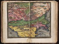
[1542]
Call Number:
Taylor 86
Collection Title:
Rvdimenta cosmographica
Image Count:
1
Subject (Geographic):
Balkan Peninsula
Subject (Topic):
Cosmography, Early maps, and Geography, Medieval
Collection Created:
Impressvm in inclyta Transylvaniae Corona 1542
Found in:
Beinecke Rare Book and Manuscript Library > [Map of the Balkan Peninsula including Macedonia, Blugaria, Moldova]
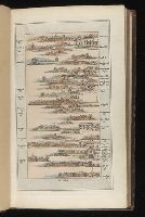
Published / Created:
1802
Call Number:
Im B388 Zz802B
Collection Title:
The imperial guide : with picturesque plans of the great post roads, containing miniatures
Image Count:
1
Description:
Bound in between p. 24-25. and William Beckford’s copy, with his penciled annotations. Autograph of William Beckford.
Subject (Geographic):
England --Guidebooks, England --Maps, Great Britain --Description and travel --Views, and Great Britain --Road maps
Subject (Topic):
Roads --Great Britain
Collection Created:
London : Printed by C. Whittingham, Dean Street, Fetter Lane, and sold by H.D. Symonds, Paternoster-Row; [etc], 1802
Found in:
Beinecke Rare Book and Manuscript Library > [Map: Carlisle to Bolton]
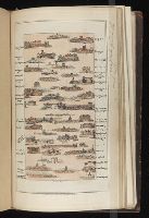
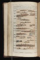
Published / Created:
1802
Call Number:
Im B388 Zz802B
Collection Title:
The imperial guide : with picturesque plans of the great post roads, containing miniatures
Image Count:
1
Description:
Bound in between p. 4-5. and William Beckford’s copy, with his penciled annotations. Autograph of William Beckford.
Subject (Geographic):
England --Guidebooks, England --Maps, Great Britain --Description and travel --Views, and Great Britain --Road maps
Subject (Topic):
Roads --Great Britain
Collection Created:
London : Printed by C. Whittingham, Dean Street, Fetter Lane, and sold by H.D. Symonds, Paternoster-Row; [etc], 1802
Found in:
Beinecke Rare Book and Manuscript Library > [Map: Coventry to Stony Stratford]
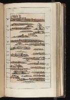
Published / Created:
1802
Call Number:
Im B388 Zz802B
Collection Title:
The imperial guide : with picturesque plans of the great post roads, containing miniatures
Image Count:
1
Description:
Bound in between p. 38-39. and William Beckford’s copy, with his penciled annotations. Autograph of William Beckford.
Subject (Geographic):
England --Guidebooks, England --Maps, Great Britain --Description and travel --Views, and Great Britain --Road maps
Subject (Topic):
Roads --Great Britain
Collection Created:
London : Printed by C. Whittingham, Dean Street, Fetter Lane, and sold by H.D. Symonds, Paternoster-Row; [etc], 1802
Found in:
Beinecke Rare Book and Manuscript Library > [Map: Islip to Paddington]
Published / Created:
1802
Call Number:
Im B388 Zz802B
Collection Title:
The imperial guide : with picturesque plans of the great post roads, containing miniatures
Image Count:
1
Description:
Bound in between p. 22-23. and William Beckford’s copy, with his penciled annotations. Autograph of William Beckford.
Subject (Geographic):
England --Guidebooks, England --Maps, Great Britain --Description and travel --Views, and Great Britain --Road maps
Subject (Topic):
Roads --Great Britain
Collection Created:
London : Printed by C. Whittingham, Dean Street, Fetter Lane, and sold by H.D. Symonds, Paternoster-Row; [etc], 1802
Found in:
Beinecke Rare Book and Manuscript Library > [Map: Lancaster to Worsley]
Published / Created:
1802
Call Number:
Im B388 Zz802B
Collection Title:
The imperial guide : with picturesque plans of the great post roads, containing miniatures
Image Count:
1
Description:
Bound in between p. 6-7. and William Beckford’s copy, with his penciled annotations. Autograph of William Beckford.
Subject (Geographic):
England --Guidebooks, England --Maps, Great Britain --Description and travel --Views, and Great Britain --Road maps
Subject (Topic):
Roads --Great Britain
Collection Created:
London : Printed by C. Whittingham, Dean Street, Fetter Lane, and sold by H.D. Symonds, Paternoster-Row; [etc], 1802
Found in:
Beinecke Rare Book and Manuscript Library > [Map: Stafford to Coventry]
Published / Created:
1802
Call Number:
Im B388 Zz802B
Collection Title:
The imperial guide : with picturesque plans of the great post roads, containing miniatures
Image Count:
1
Description:
Bound in between p. 10-11. and William Beckford’s copy, with his penciled annotations. Autograph of William Beckford.
Subject (Geographic):
England --Guidebooks, England --Maps, Great Britain --Description and travel --Views, and Great Britain --Road maps
Subject (Topic):
Roads --Great Britain
Collection Created:
London : Printed by C. Whittingham, Dean Street, Fetter Lane, and sold by H.D. Symonds, Paternoster-Row; [etc], 1802
Found in:
Beinecke Rare Book and Manuscript Library > [Map: Talk on the Hill to Birmingham]
Creator:
Published / Created:
undated
Call Number:
WA MSS S-1741 BrSides
Collection Title:
Colorado Midland Railway Company maps
Container / Volume:
Folder 9
Image Count:
22
Resource Type:
Maps, Atlases & Globes
Description:
Folder also contain 2 MS notes in pencil, 21 cm. and smaller. and Versos blank, not digitized.
Subject (Geographic):
Aspen (Colo.)--Maps, Colorado--Maps, Garfield County (Colo.)--Maps, and Pitkin County (Colo.)--Maps
Subject (Name):
Colorado Midland Railway Company
Subject (Topic):
Mines and mineral resources--Colorado--Maps and Railroads--Colorado--Maps
Found in:
Beinecke Rare Book and Manuscript Library > [Maps of Aspen Branch, Jerome Park Branch, Pitkin-Garfield Counties, Colorado]
Creator:
Published / Created:
undated
Call Number:
WA MSS S-1741 BrSides
Collection Title:
Colorado Midland Railway Company maps
Container / Volume:
Folder 2
Image Count:
10
Resource Type:
Maps, Atlases & Globes
Description:
Folder includes indes of maps on ledger paper, 44 x 56 cm. and Versos blank, not digitized.
Subject (Geographic):
Colorado--Maps, Garfield County (Colo.)--Maps, and Glenwood Springs (Colo.)--Maps
Subject (Name):
Colorado Midland Railway Company
Subject (Topic):
Mines and mineral resources--Colorado--Maps and Railroads--Colorado--Maps
Found in:
Beinecke Rare Book and Manuscript Library > [Maps of Garfield County, Colorado]
Creator:
Published / Created:
undated
Call Number:
WA MSS S-1741 BrSides
Collection Title:
Colorado Midland Railway Company maps
Container / Volume:
Folder 1
Image Count:
8
Resource Type:
Maps, Atlases & Globes
Abstract:
107 colored manuscript railroad maps, detailing the line of the Colorado Midland Railway between Park County and Pitkin and Garfield Counties. The highly detailed maps depict county ranges and townships, survey points and mileage markers, depots, canyons, bridges, sidings, trestles, tunnels, rivers, creeks, etc.; adjacent railroad lines and rights-of-way; hamlets, villages, settlements, ranches, farms, etc.; and plats of the towns of Buena Vista, Leadville, Glenwood Springs, and Aspen. Counties covered are Chaffee, Eagle, Garfield, Lake, Park, and Pitkin. Accompanied by an incomplete index (1 leaf) entitled "Valuation Section [?] Colo. Midland Ry" and two leaves of surveying notes.
Description:
Versos blank, not digitized.
Subject (Geographic):
Colorado--Maps and Garfield County (Colo.)--Maps
Subject (Name):
Colorado Midland Railway Company
Subject (Topic):
Mines and mineral resources--Colorado--Maps and Railroads--Colorado--Maps
Found in:
Beinecke Rare Book and Manuscript Library > [Maps of Garfield County, Colorado]
Branch:v1.61.8 ,Deployed:2024-06-20T11:15:15-04:00