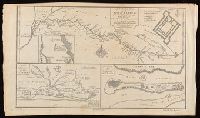
Coastal chart., Imperfect: Mutilated with loss of information., Includes text: "Instructions for the coast of South Carolina, Georgia, and the coast of St. Augustin"., and Oriented with north to the left.
Publisher:
W. Mount and T. Page,
Subject (Geographic):
Atlantic Coast (South Atlantic States)--Maps., Georgia--Maps--Early works to 1800., and South Carolina--Maps--Early works to 1800.
Subject (Topic):
Coastwise navigation--Atlantic Coast (South Atlantic States)
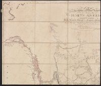
From A new general collection of voyages and travels (London, 1745-47)., In lower left corner: "No. 38.", Numbered: plate IX. Vol. II, p. 45., Relief shown pictorially., Shows River Sanaga, its tributaries, the location and plan of Fort St. Joseph, and the island of Sanaga., and Watermark.
Publisher:
Labat,
Subject (Geographic):
Cameroon--Maps--Early works to 1800. and River Sanaga (Cameroon)--Maps--Early works to 1800.
Subject (Name):
Child, G., engraver. and Labat, Jean Baptiste, 1663-1738, publisher.
Appears in Atlas to Thompson's Alcedo; or, dictionary of America & West Indies, 1816., Relief shown by hachures., and Shows points of interest, aids to navigation, and historical information.
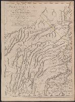
Imprint in three places along lower left, center, and right margin., Prime meridian: London. "Longitude west from London.", Relief shown by shading and hachures., and Revolutionary War era map of Pennsylvania, compiled by Sayer & Bennett, primarily from William
Publisher:
Printed for Robt. Sayer & J. Bennett, map & printseller No. 53 in Fleet Street. Published as the Act directs,
Subject (Geographic):
Pennsylvania--Administrative and political divisions--Maps--Early works to 1800. and Pennsylvania--Maps--Early works to 1800.
Subject (Name):
Penn, Richard, 1706-1771, dedicatee., Penn, Thomas, 1702-1775, dedicatee., and Robert Sayer and John Bennett (Firm), publisher, printseller.
Imprint in three places along lower left, center, and right margin., Prime meridian: London. "Longitude west from London.", Relief shown by shading and hachures., Revolutionary War era map of Pennsylvania, compiled by Sayer & Bennett, primarily from William Schull's map. The detailed map extending from Fort Pitt (formerly Fort Duquesne) in the west to the New Jersey border along the Delaware river to the east., Scale of "English Miles 69 1/2 to a Degree"., Separately published and in editions of "The North American Atlas" published by Faden; and Thomas Jefferys' The American atlas. 1775;, and Shows counties, townships, towns and cities, Indian villages, stores, churches, taverns, and names of residents in the countryside; rivers and streams, waterfalls, ferries, swamps, springs, and landmarks; mills, mines, furnaces, and forges; and forts and French and Indian War battle sites. - Cf. Seller & Van Ee, Maps and charts of North America and West Indies, 1750-1789, entry 1296.
Publisher:
Printed for Robt. Sayer & J. Bennett, map & printseller No. 53 in Fleet Street. Published as the Act directs,
Subject (Geographic):
Pennsylvania--Administrative and political divisions--Maps--Early works to 1800. and Pennsylvania--Maps--Early works to 1800.
Subject (Name):
Penn, Richard, 1706-1771, dedicatee., Penn, Thomas, 1702-1775, dedicatee., and Robert Sayer and John Bennett (Firm), publisher, printseller.
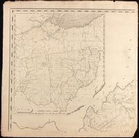
Dedication: To the General Assembly of Virginia this map is respectfully inscribed by their fellow citizens, James Madison, William Prentis, William Davis, proprietors., Imperfect: all sheets but upper northwest sheet (with map of "Ohio") wanting., Includes inset map of Ohio., Insets: [View of] The city of Richmond, metropolis of Virginia -- Ohio., Prime meridian: Washingtion., Relief shown by hachures., and Shows state and county boundaries, roads, towns and villages, courthouses, dwelling houses, iron works, mills, and salt works.
Publisher:
by the Proprietors,
Subject (Geographic):
Ohio--Maps., Richmond (Va.)--Pictorial works., and Virginia--Maps.
Includes brief notes on the Irish history and political divisions., Inset: The sea coasts of Great Britain and Ireland. Scale approximately 1:4,500,000., Originally printed on 4 sheets., Relief shown pictorially., Robert Sayer traded alone & at this address 1751-1774 and 1783-1792 (cf. Maxted, p. l99)., Shows boundaries, rivers, lochs, roads with distances, woods and settlements., and Title cartouche depicts engraved stone, cow, and reclining figure holding a peat spade.
Publisher:
Printed for Robt. Sayer, opposite Fetter Lane, Fleet Street,