"J.D. Whitney, State Geologist.", Extends from the Pacific to central Nevada, north to Shasta, south to Visalia., Library's copy 2 and 3 without northern sheets., and Relief shown by hachures; northwest sheet planimetric.
Publisher:
State Geological Survey of California,
Subject (Geographic):
California--Maps, Topographic and Nevada--Maps, Topographic
Subject (Name):
Bien, Julius, 1826-1909, Hoffmann, C. F. (Charles Frederick), 1838-1913, and Whitney, J. D. (Josiah Dwight), 1819-1896
Includes 5 insets, var. scales: Hypsometrical and bathymetrical chart -- Political division of the Japanese Empire -- Chishima (Kurile Islands) -- [Taiwan and Ryūkyū Islands] -- Ogasawa-Jima (Bonin Islands), Ka and Relief shown by contours and spot heights.
Publisher:
Tōyōdō,
Subject (Geographic):
Japan--Administrative and political divisions--Maps, Japan--Maps, and Taiwan--Maps
Subject (Name):
Matsudaira, N, Suzuki, Kiyotada, and Togawa, Tametsugu
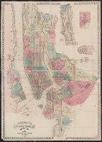
Topographical map of the cities of New York, Brooklyn, Jersey City and Hoboken
Description:
Hand colored., Insets: New York County north of 150th St. -- Map of New Neth, and Shows wards, other unspecified districts, ferry lines, some buildings and topographical details of surrounding islands, and parts of Queens County and New Jersey north of Hoboken.
Publisher:
M. Dripps,
Subject (Geographic):
Brooklyn (New York, N.Y.)--Administrative and political divisions--Maps, Brooklyn (New York, N.Y.)--Maps, Hoboken (N.J.)--Maps, Jersey City (N.J.)--, and New York (N.Y.)--Administrative and political divisions--Maps