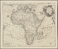
Africa accuraté in imperia, regna, status & populos divisa, ad usum serenissimi Bourgundiae Ducis.
Description:
"Avec privil[ège].", Appeared in various eds. of Cóvens et Mortier's Atlas noveau; cf. Koeman, C. Atlantes Neerlandici, Coverage includes the eastern coast of Brazil., II, C & M 3 and 4., Includes four bar scales., and Relief shown pictorially.
No. 13 of 69 maps bound together in composite atlas., Oriented with north towards upper left., Relief shown pictorially., Scale not given., and Title in Latin; place names in French.
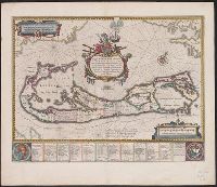
Mappa Aestivarvm insularum, alias Barmvdas dictarum
Description:
Based on Speed's map of 1626 but with new decorations., Below map, list of proprietors in 12 columns with arms of England and Bermuda., From the author's Theatre du monde ou nouvel atlas., Latin and English text on recto and French text on verso., Signature on verso: G., and Title on verso: L'Isle de Barmudas, avec ses voysines.
Publisher:
[Guillaume et Iean Blaeu,
Subject (Geographic):
Bermuda Islands--Maps--Early works to 1800
Subject (Name):
Blaeu, Joan, 1596-1673. Theatrum orbis terrarum. French and Blaeu, Willem Janszoon, 1571-1638. Theatrum orbis terrarum. French
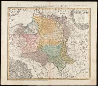
"La couleure violette marque les pays démembrés de la Pologne en 1772, conformément aux prétensions des trois Puissances voisines."--Lower left margin., Includes coat-of-arms, and 3 bar scales., Map in Latin; alternate title and legend in French., Prime meridian: Paris., Relief shown pictorially., and Watermark. Manuscript number in upper right corner. From the Karpinski-von Wieser Map Collection.
Publisher:
Luci publicae tradita per Homannianos Heredes
Subject (Geographic):
Belarus--Maps--Early works to 1800., Lithuania--Maps--Early works to 1800., Poland--Maps--Early works to 1800., and Ukraine--Maps--Early works to 1800.
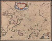
Nova et accvrata Poli Arctici et terrarum circum Iacentium descriptio
Description:
Cross collection no. 51., From: Nouvel atlas, ou, Theatre du Monde ... Amstelodami : Apud Ioannem Ianssonium, 1649., In Latin, with French text on verso; running title "Description"; caption title "Le pole Arctique avec les regions situees dessous"; sig. P., and Includes ill. and decorative cartouche.
Publisher:
Apud Ioannem Ianssonium,
Subject (Geographic):
Arctic Regions--Maps--Early works to 1800
Subject (Name):
Jansson, Jan, 1588-1664. Nouvel atlas, ou, theatre du monde
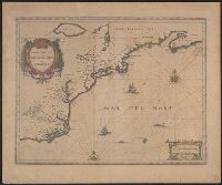
Hand col. Sheet measures 47 x 58 cm., Has watermarks., Includes decorative cartouche and ill., Latin, with French text on verso., On verso, right top margin: 313., Relief shown pictorially., and Signature on verso: Xxxxxx.
Appears in French editions of Jansson's and Hondius's Atlas n, French text on verso, with signature 5d., Hand col. Sheet measures 47.5 x 57 cm., Relief shown pictorially., and Stamp on verso: Yale University Library Karpinski-von Wieser Map Collection.
Publisher:
Johannes Janssonius excudit,
Subject (Geographic):
Atlantic States--Maps--Early works to 1800 and Maritime Provinces--Maps--Early works to 1800
Subject (Name):
Hondius, Hendrik, 1597-1651. Atlas novus. French and Jansson, Jan, 1588-1664. Atlas novus. French
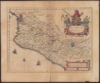
Bar scale given in "milliaria Hispanica.", Cross Collection no. 311., From Blaeu's Le theatre du monde ... Amsterdami : Apud Guiljelmum et Iohannem Blaeu, 1635., Imperfect: torn half-way along fold., In French on verso, with caption title "La novvelle Espagne" and signature C6., Includes "Notarum explanatio" and ill., and Relief shown pictorially.
Publisher:
Willem and Joan Blaeu,
Subject (Geographic):
Mexico--Maps--Early works to 1800
Subject (Name):
Blaeu, Joan, 1596-1673. Theatrum orbis terrarum. French and Blaeu, Willem Janszoon, 1571-1638. Theatrum orbis terrarum. French
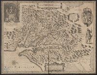
French text on verso, with running and caption title "Virginie," signature e, and catchword "ses.", From Jan Jansson's Nouvel atlas ... Amstelodami : Apud Ioannem Ianssonium, 1646-1649., Hendrik Hondius' derivative of John Smith's map of Virginia, 1612., and Ori
Publisher:
Ex officina Henrici Hondii,
Subject (Geographic):
Chesapeake Bay (Md. and Va.)--Maps--Early works to 1800, Maryland--Maps--Early works to 1800, and Virginia--Maps--Early works to 1800
Subject (Name):
Jansson, Jan, 1588-1664. Atlas novus. French and Smith, John, 1580-1631