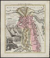
"Joannes Christophorus I.B. Homanni filius delineavit. Cum privilegio Sac. Caes. Majestatis.", Hand col. Sheet measures 65.5 x 56.5 cm., Includes illustrations of cataracts of the Nile, the pyramids, tombs, various antiquities, sce, and Relief shown by hachures.
"Cum privilegio Sac. Caes. Majestatis.", Bar scales given in "milliaria Germanica," "milliaria Gallica," and ""milliaria Italica.", Manuscript number in upper right corner: 43. From the Karpinski-von Wieser Map Collection., and Relief shown pictorially.
Publisher:
[Johann Baptist Homann]
Subject (Geographic):
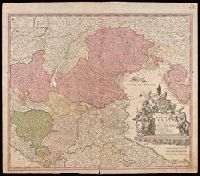
Italy, Northern--Maps--Early works to 1800. and Veneto (Italy)--Maps--Early works to 1800.
[Atlas factice of 50 maps, primarily by Johann Baptist Homann and/or issued by the Homann Erben
Image Count:
1
Publisher:
[Johann Baptist Homann]
Subject (Geographic):
Carniola (Slovenia) --Maps --Early works to 1800, Croatia --Maps --Early works to 1800, and Ljubljana (Slovenia) --Maps, Pictorial --Early works to 1800
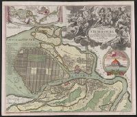
Hand col. Sheet measures 54 x 63 cm. Lada-Mocarski collection., Index to points of interest, and col. illus. of "Crohn Schlot oder Cron Schloss.", and Inset map: "Charte des Neva-Stroms von der Ladogisthen biss in die Ost-See allwo St. Petersburg ... "
Publisher:
Ioh. Baptist Homann,
Subject (Geographic):
Neva River (Russia)--Maps--Early works to 1800 and Saint Petersburg (Russia)--Maps--Early works to 1800