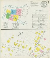
Sanborn fire insurance maps are a rich source of historic data on the urban built environment of North America during the 19th and early 20th centuries. The atlases were created for the purpose of underwriting fire insurance policies, which depended upon accurate and frequently-updated information about construction materials, municipal and transportation infrastructure, industrial and commercial landuse and more. The Yale University Library Map Department scanned its holdings of Sanborn fire insurance maps (consisting primarily of Connecticut towns) in order to make the maps more accessible.
Alternative Title:
Dec. 1901, Jewett City, Conn.
Description:
"5 sheets.", Contains information on population, prevailing winds, water facilities and fire department., Includes index of streets and specials., Partial cadastral map., and SMLMAPL 766 J55 1901: Sheets disbound. "Triplicate" stamp on all sheets. Library of Congress copyright stamp on title sheet.
Subject (Geographic):
Jewett City (Conn.)--Maps
Subject (Name):
Library of Congress Stamp
Subject (Topic):
Fire risk assessment--Connecticut--Jewett City--Maps and Real property--Connecticut--Jewett City--Maps
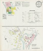
Sanborn fire insurance maps are a rich source of historic data on the urban built environment of North America during the 19th and early 20th centuries. The atlases were created for the purpose of underwriting fire insurance policies, which depended upon accurate and frequently-updated information about construction materials, municipal and transportation infrastructure, industrial and commercial landuse and more. The Yale University Library Map Department scanned its holdings of Sanborn fire insurance maps (consisting primarily of Connecticut towns) in order to make the maps more accessible.
Alternative Title:
Feb. 1901, Jewett City, Conn.
Description:
"1738. (6 sheets.)", Contains information on population, prevailing winds, water facilities and fire department., Includes index of streets and specials., Partial cadastral map., and SMLMAPL 766 J55 1917: Sheets disbound. "Triplicate" stamp on all sheets. Library of Congress copyright stamp on title sheet.
Subject (Geographic):
Jewett City (Conn.)--Maps
Subject (Name):
Library of Congress Stamp
Subject (Topic):
Fire risk assessment--Connecticut--Jewett City--Maps and Real property--Connecticut--Jewett City--Maps
Sanborn fire insurance maps are a rich source of historic data on the urban built environment of North America during the 19th and early 20th centuries. The atlases were created for the purpose of underwriting fire insurance policies, which depended upon accurate and frequently-updated information about construction materials, municipal and transportation infrastructure, industrial and commercial landuse and more. The Yale University Library Map Department scanned its holdings of Sanborn fire insurance maps (consisting primarily of Connecticut towns) in order to make the maps more accessible.
Alternative Title:
1924, Jewett City, Conn.
Description:
"(1667). 7 sheets.", Contains information on population, prevailing winds, water facilities and fire department., Includes index of streets and specials., Partial cadastral map., Sheets 2-5 at scale 1:600; sheets 1 and 6-7 at scale 1:1,200., and SMLMAPL 766 J55 1924: Sheets disbound. Library of Congress copyright stamp on title sheet.
Subject (Geographic):
Jewett City (Conn.)--Maps
Subject (Name):
Library of Congress Stamp
Subject (Topic):
Fire risk assessment--Connecticut--Jewett City--Maps and Real property--Connecticut--Jewett City--Maps
Карта : описи и промеру глубины, части дниепровскаго Лимана и реки Буга до Николаева / сочинена флота господином капитанъ лейтнантомъ Александром Савицкимъ 1793 года.
Description:
Depths shown by soundings.
Subject (Geographic):
Dnieper River--Maps--Early works to 1800.
Subject (Name):
Savit︠s︡kiĭ, Aleksandr, -1799. and Савицкий, Александр, -1799.
Russia. Generalʹnyĭ shtab Россия. Генеральный штаб
Call Number:
54 1864
Container / Volume:
BRBL_00290
Image Count:
1
Resource Type:
Maps, Atlases & Globes
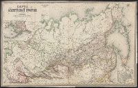
Alternative Title:
[Saint Peterburg] : Хроматографическое и Металлографическое Заведения Полторацкого Ильина и Ко., Karta vladi︠e︡nīĭ Rossīĭsko Amerikanskoĭ Kompanīi., К, and Карта Азіятской Россіи / составлена по новѣйшим свѣдѣніям генерального Штаба подполковником Ильиным.
Description:
"Dozvoleno T︠s︡enz, "Дозволено Цензурой C. Петербург 12 Маія 1864.", Includes inset map "Karta vladi︠e︡nīĭ Rossīĭsko Amerikanskoĭ Kompanīi" (scale 1:21,000,000)., and Includes inset map "Карта владѣний Российско Американской Компаніи" (scale 1:21,000,000).
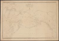
Generalʹnai︠a︡ karta Ledovitago mori︠a︡ i Vostochnago okeana, Генеральная карта Ледовитаго моря и Восточнаго океана, and Карта Ледовитаго моря и Восточнаго океана / составлена сь новѣйших описей в Географическом департаментѣ Морскаго министерства.
Description:
"1345" in lower left corner., "Noi︠a︡ 1858" in lower left corner., "Ноя. 1858" in lower left corner., Depths shown by soundings in coastal waters., Greenwich, Paris, and Petersburg meridians; Greenwich degrees numbered westward to 240°., and Includes Hydrographic
Subject (Geographic):
Alaska--Maps, Arctic Ocean--Maps, North Pacific Ocean--Maps, and Russian Far East (Russia)--Maps