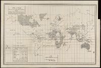
Covers Nova Scotia, New Brunswick, Prince Edward Island, and part of Quebec., Includes text in lower margin., Manuscript note at bottom below price, "Plain or Coloud.", Prime meridian: London., and Relief shown pictorially.
Publisher:
Publish'd according to Act of Parlian't Apr'l 21st, 1749, by Ino. Gibson engraver in Bartlet Street Clerkenwell & sold by the printsellers in London & Westminster,
Subject (Geographic):
Acadia--Maps--Early works to 1800., Maritime Provinces--Maps--Early works to 1800., North America--Acadia, and Québec (Province)--Maps--Early works to 1800.
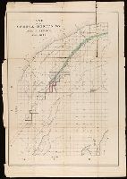
"County lines in red lines.", Manuscript annotations showing location of mines discovered and opened on Menomonee Iron Range and line of projected narrow gauge railway. From the Richard H. Rickard Papers., Prime meridian: Greenwich., and Shows cities, counties, railroads completed, and railroads projected.
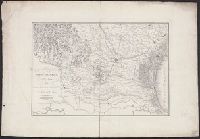
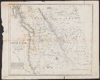
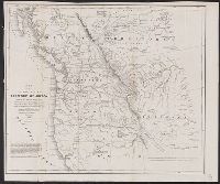
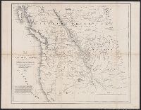
Abert, John James, 1788-1863, Arnold, Robert M.--Ownership, Hudson's Bay Company, Hudson's Bay Company--Maps, Stansbury, M. H, Stenzel, Franz--Ownership, and Stenzel, Kathryn M.--(Kathryn Mathi
From the collection of Robert M. Arnold., Includes text., and Relief shown by hachures.
Publisher:
U.S. Senate,
Subject (Geographic):
Northwest, Pacific--Maps
Subject (Name):
Abert, John James, 1788-1863, Arnold, Robert M.--Ownership, Hudson's Bay Company, Hudson's Bay Company--Maps, Stansbury, M. H, Stenzel, Franz--Ownership, and Stenzel, Kathryn M.--(Kathryn Mathi
Includes text., Mounted on linen., and Relief shown by hachures.
Publisher:
U.S. Senate,
Subject (Geographic):
Northwest, Pacific--Maps
Subject (Name):
Abert, John James, 1788-1863, Arnold, Robert M.--Ownership, Hudson's Bay Company, Hudson's Bay Company--Maps, Stansbury, M. H, Stenzel, Franz--Ownership, and Stenzel, Kathryn M.--(Kathryn Mathi
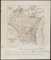
Shows railroads, corporate land ownership, plats of Marquette and Negaunee, sawmill locations in all or parts of sections T.47-48 N, R. 25-27 W.
Description:
Backed with linen. Manuscript annotations on map. Manuscript title on verso: Marquette Iron Region. From the Richard H. Rickard Papers., Coordinates not present on map and are approximated., Detached from: A statement of the plan of the St. Mary's Canal Mineral Land Company (New York : Baker & Godwin, printers, 1859)., and Relief shown by hachures.
Publisher:
[Baker & Godwin, printers],
Subject (Geographic):
Michigan--Upper Peninsula
Subject (Name):
Collins Iron Company--Maps., Excelsior Iron Company--Maps., Jackson Iron Company (Fayette, Mich.)--Maps., Peninsula Iron Company--Maps., Pioneer Iron Company--Maps., and Rickard, Richard H.,---1885--Owner
Subject (Topic):
Iron mines and mining, Iron mines and mining--Michigan--Upper Peninsula--Maps., Real property, and Real property--Michigan--Upper Peninsula--Maps.