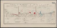
1. Beaches of Normandy - Vierville to Houlgate [cartographic material] / compiled and drawn in the Creator: United States. Office of Strategic Services. Research and Analysis Branch Published / Created: [1943] Call Number: 382 1943 Container / Volume: BRBL_00175 Image Count: 1 Resource Type: Maps, Atlases & Globes Description: "22 November 1943." Subject (Geographic): Normandy (France)--Maps Subject (Topic): Beaches--France--Normandy--Maps Found in: Beinecke Rare Book and Manuscript Library > Beaches of Normandy - Vierville to Houlgate [cartographic material] / compiled and drawn in the Branch of Research and Analysis, OSS.
2. Philippine Islands, transportation facilities of the southern Visayan Islands. Creator: United States. Office of Strategic Services. Research and Analysis Branch Published / Created: 1944 Call Number: 28 1944C Container / Volume: BRBL_00023E Image Count: 1 Resource Type: Maps, Atlases & Globes Description: "No. 3764--R & A, OSS; 22 June 1944." Subject (Geographic): Visayan Islands (Philippines)--Maps Subject (Topic): --Maps Found in: Beinecke Rare Book and Manuscript Library > Philippine Islands, transportation facilities of the southern Visayan Islands.
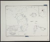
3. Philippine Islands, transportation facilities of the northern Visayan Islands. Creator: United States. Office of Strategic Services. Research and Analysis Branch Published / Created: 1944 Call Number: 28 1944D Container / Volume: BRBL_00023E Image Count: 1 Resource Type: Maps, Atlases & Globes Description: "No. 3417--R & A, OSS; 22 June 1944." Subject (Geographic): Visayan Islands (Philippines)--Maps Subject (Topic): --Maps Found in: Beinecke Rare Book and Manuscript Library > Philippine Islands, transportation facilities of the northern Visayan Islands.