Search
You Searched For
Search Results
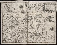
- Creator:
- Langren, Arnold Florent van, 1580-1644
- Published / Created:
- 1595
- Call Number:
- Pequot +L65
- Collection Title:
- Nauigatio ac itinerarium Iohannis Hugonis Linscotani in Orientalem siue Lusitanorum Indiam
- Image Count:
- 1
- Description:
- Bound in following page 22.
- Subject (Geographic):
- Borneo --Maps
- Found in:
- Beinecke Rare Book and Manuscript Library > Exacta & accurata delineatio cum orarum maritimarum tum etiam locorum terrestrium quae in regionibus China, Cauchinchina, Camboia sive Champa, Syao, Malacca, Arracamn & Pegu ...
- Creator:
- From the Collection: Kissinger, Henry, 1923-2023
- Published / Created:
- 2004
- Call Number:
- MS 1981
- Container / Volume:
- Box 745, folder 9
- Image Count:
- 176
- Found in:
- Manuscripts and Archives > Henry A. Kissinger papers, part II (MS 1981) > Series III: Post-Government Career > Speeches and writings > General > Testimony before Senate Foreign Relations Committee on "Middle East: Re-thinking the Road Map," Feb 24, 2004 [2 of 2]
- Creator:
- From the Collection: Kissinger, Henry, 1923-2023
- Published / Created:
- 2004
- Call Number:
- MS 1981
- Container / Volume:
- Box 745, folder 8
- Image Count:
- 318
- Found in:
- Manuscripts and Archives > Henry A. Kissinger papers, part II (MS 1981) > Series III: Post-Government Career > Speeches and writings > General > Testimony before Senate Foreign Relations Committee on "Middle East: Re-thinking the Road Map," Feb 24, 2004 [1 of 2]
- Call Number:
- WA MSS 443
- Collection Title:
- Isaac Ingalls Stevens papers
- Container / Volume:
- Box 2 | Folder 29
- Image Count:
- 51
- Resource Type:
- Archives or Manuscripts
- Abstract:
- . I. Stevens. 49 p.
Map, "Plan of the
- Found in:
- Beinecke Rare Book and Manuscript Library > [Delacy, Walter Washington]
- Creator:
- Faden, William, 1749-1836
Jefferys, Thomas, d. 1771, creator
- Published / Created:
- 1789 June 1
- Call Number:
- 1982 Folio 10
- Image Count:
- 1
- Description:
- No. 22 of 43 maps bound together in
- Subject (Geographic):
- Germany --Maps --Early works to 1800
- Found in:
- Beinecke Rare Book and Manuscript Library > A new map of the King of Great Britain's dominions in Germany or the electorate of Brunswick-Luneburg and its dependencies
- Creator:
- L'Isle, Guillaume de, 1675-1726
- Published / Created:
- [1730?]
- Call Number:
- 755 1730
- Container / Volume:
- BRBL_00426
- Image Count:
- 1
- Resource Type:
- Maps, Atlases & Globes
- Subject (Geographic):
- Louisiana--Maps--Early works to 1800
- Found in:
- Beinecke Rare Book and Manuscript Library > Carte de la Louisiane et du cours du Mississipi / dressée sur un grand nombre de memoires entr'autres sur ceux de Mr. le Maire, par Guillme. de L'Isle de l'Academie Rle. des Sciences.
- Creator:
- Wit, Frederik de., creator
- Published / Created:
- [1706?]
- Call Number:
- 1973 Folio 10
- Image Count:
- 1
- Resource Type:
- Maps, Atlases & Globes
- Description:
- No. 22 of 69 maps bound together in
- Subject (Geographic):
- Italy, Southern --Maps --Early works to
- Found in:
- Beinecke Rare Book and Manuscript Library > Regnum Neapolis: in quo sunt Aprutium ulterius et citerius, Comitatus Molisius, Terra Laboris, Capitaniata Principatus ulterior et citerior, Terra Bariensis et Hidruntina, Basilicata, Calabria citerior et ulterior
- Creator:
- From the Collection: Stenzel, Franz
- Published / Created:
- n.d.
- Call Number:
- WA MSS S-2368
- Container / Volume:
- Box 7, folder 134
- Image Count:
- 1
- Found in:
- Beinecke Rare Book and Manuscript Library > Franz R. and Kathryn M. Stenzel collection of western American art (WA MSS S-2368) > Series II: James G. Swan Artwork and Associated Material > > ARTWORK > Works by Swan > Views of Native American Life > [Map of coastal village Alekistet?] Pencil drawing, 19.1 x 22 cm.
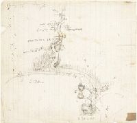
- Creator:
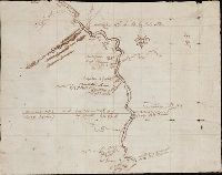
- Clark, William, 1770-1838.
Lewis, Meriwether, 1774-1809
- Published / Created:
- 1804?
- Call Number:
- WA MSS 303
- Collection Title:
- Lewis and Clark Expedition maps and receipt, ca. 1803-1810
- Container / Volume:
- Box 1 | Folder 8
- Image Count:
- 2
- Found in:
- Beinecke Rare Book and Manuscript Library > Evans's Map 5 (the Expedition's route about October 14-22, 1804)
- Creator:
- Sanborn Map Company
- Published / Created:
- August, 1923.
- Call Number:
- 776 B764 1923
- Container / Volume:
- BRBL_00502
- Image Count:
- 4
- Resource Type:
- Maps, Atlases & Globes
- Abstract:
- Fire insurance map, colored to show
- Description:
- Coordinates not present on map and are
- Publisher:
- Sanborn Map Company,
- Subject (Geographic):
- Bridgeville (Del.)--Maps.
- Subject (Topic):
- --Bridgeville--Maps.
- Found in:
- Beinecke Rare Book and Manuscript Library > Bridgeville, Sussex County, Delaware.
- Published / Created:
- 1595
- Call Number:
- Taylor 219
- Collection Title:
- Navigatio ac itinerarivm Iohannis Hvgonis Linscotani in Orientalem sive Lvsitanorvm Indiam
- Image Count:
- 1
- Description:
- Bound in following page 22.
- Subject (Geographic):
- Borneo --Maps
- Found in:
- Beinecke Rare Book and Manuscript Library > Exacta & accurata delineatio cum orarum maritimarum tum etiam locorum terrestrium quae in regionibus China, Cauchinchina, Camboia sive Champa, Syao, Malacca, Arracamn & Pegu ...
- Creator:
- From the Collection: Fellows, Abraham Lincoln, 1864-1942
- Published / Created:
- 1901-1904, n.d.
- Call Number:
- WA MSS S-1296
- Container / Volume:
- Box 3, folder 28
- Image Count:
- 146
- Found in:
- Beinecke Rare Book and Manuscript Library > Abraham Lincoln Fellows papers (WA MSS S-1296) > Gunnison Tunnel Files > Photograph album: Gunnison Tunnel
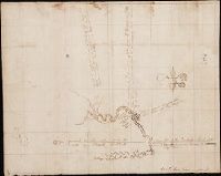
- Creator:
- Lewis, Meriwether, 1774-1809
- Published / Created:
- 1804
- Call Number:
- WA MSS 303
- Collection Title:
- Lewis and Clark Expedition maps and receipt, ca. 1803-1810
- Container / Volume:
- Box 1 | Folder 9
- Image Count:
- 2
- Found in:
- Beinecke Rare Book and Manuscript Library > Evans's Map 6 (the Expedition's route about October 22-November 1, 1804)
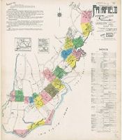
- Creator:
- Sanborn Map Company, issuing body
- Published / Created:
- 1922
- Call Number:
- 766 F16 1922
- Image Count:
- 22
- Resource Type:
- Maps, Atlases & Globes
- Abstract:
- Sanborn fire insurance maps are a rich
- Description:
- "22 sheets (5093)."
- Subject (Geographic):
- Fairfield (Conn.)--Maps
- Subject (Topic):
- --Fairfield--Maps
- Found in:
- Beinecke Rare Book and Manuscript Library > Fairfield, Fairfield County, Connecticut.
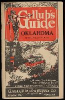
- Published / Created:
- [193-?]
- Call Number:
- Zc41 930ga
- Image Count:
- 28
- Alternative Title:
- Gallup's guide auto route & highway map
- Publisher:
- Gallup Map & Supply Co.
- Found in:
- Beinecke Rare Book and Manuscript Library > Gallup's guide Oklahoma, northern Texas southern Kansas : showing population and distance between towns, United States auto road map on back [of state map].
- Creator:
- Faden, William, 1749-1836
- Published / Created:
- 1777
- Call Number:
- 73 1777
- Container / Volume:
- BRBL_00373
- Image Count:
- 1
- Resource Type:
- Maps, Atlases & Globes
- Alternative Title:
- [American maps ; v. 3, no. 22]
- Subject (Geographic):
- Canada--Boundaries--United States--Maps
- Found in:
- Beinecke Rare Book and Manuscript Library > A map of the inhabited part of Canada from the French surveys, with the frontiers of New York and New England; from the large survey by Claude Joseph Sauthier. Engraved by Wm. Faden, 1777.
- Creator:
- Winterbotham, Harold St. John Loyd, 1878-1946.
- Published / Created:
- 1927-1929.
- Call Number:
- GEN MSS 583
- Image Count:
- 103
- Resource Type:
- Archives or Manuscripts
- Abstract:
- album by a map of the region with
- Found in:
- Beinecke Rare Book and Manuscript Library > Africa : a survey inspection tour.
- Creator:
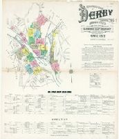
- Sanborn Map Company, issuing body
- Published / Created:
- 1912
- Call Number:
- 766 D444 1912
- Image Count:
- 22
- Resource Type:
- Maps, Atlases & Globes
- Abstract:
- Sanborn fire insurance maps are a rich
- Description:
- "22 sheets. (4763)."
- Subject (Geographic):
- Derby (Conn.)--Maps
- Subject (Name):
- Library of Congress. Map Division Stamp
- Subject (Topic):
- --Derby--Maps
- Found in:
- Beinecke Rare Book and Manuscript Library > Insurance maps of Derby and Shelton, New Haven County, Connecticut.