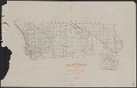
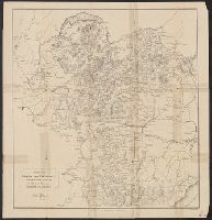
Also covers Imperial County., Includes inset of "Portion of Julian District.", Issued with: Register of mines and minerals, San Diego County, California., and Shows mining localities.
Publisher:
California State Mining Bureau,
Subject (Topic):
Mines and mineral resources--California--Imperial County--Maps and Mines and mineral resources--California--San Diego County--Maps
"History maps, Ken G. Cathcart.", "Map and some engravings from 'Annals of S.F.' with reconstructions, new drawings, and added data.", Copyright: K.G. Cathcart., Includes index, ill., and text., and Oriented with north toward the lower right.
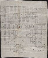
Autograph manuscript map, drawn on cloth, of San Francisco, California, showing streets and numbered lots, some with names of owners indicated.
Description:
Map has been repaired with two pieces of tape or cloth to the left of the inscription., Map has small brown stain in center that can be seen on both the recto and verso., Map was previously folded., The ink of the "I" and "S" in "Francisco" are smudged at the bottom in "Bay of San Francisco"., Verso blank., and Written on the map is a certification of its content signed by Washington A. Bartlett, Chief Magistrate, dated Feb 22, 1847.
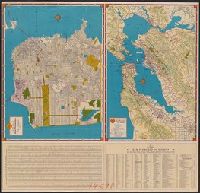
Metropolitan San Francisco and vicinity., Shell map of San Francisco, Oakland and vicinity, Shell metropolitan San Francisco and vicinity., Shell street map of Bay cities., Shell street map of San Francisco., Street map of Bay cities., and Street map of San Francis
Description:
"1940-1", Index and text on verso., Indexed., Panel title., Relief shown by shading, hachures, and spot heights., and Street map of San Francisco -- Metropolitan San Francisco and vicinity -- Street map of Bay cities.
Publisher:
H.M. Goushá Co.,
Subject (Geographic):
Oakland Metropolitan Area (Calif.)--Maps, San Francisco (Calif.)--Maps, and San Francisco Bay Area (Calif.)--Maps
Subject (Name):
Shell Union Oil Corporation
Subject (Topic):
Roads--California--Oakland Metropolitan Area--Maps, Roads--California--San Francisco Bay Area--Maps, and Streets--California--San Francisco--Maps
Map of Montecito, Carpinteria and Summerland. and Map of Santa Barbara, Montecito, Goleta, Carpinteria, Hope Ranch, Summerland
Description:
Also includes index and inset., Includes indexed route of scenic historical points of interest overprinted on map in red: Santa Barbara golden trail of history., and On verso are ill., advertisement, and "Map of Montecito, Carpinteria and Summerland."
Publisher:
The Co.,
Subject (Geographic):
Carpinteria (Calif.)--Maps, Goleta (Calif.)--Maps, Hope Ranch (Calif.)--Maps, Montecito (Calif.)--Maps, Santa Barbara (Calif.)--Maps, and Summerland (Calif.)--Maps
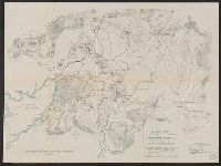
"Approx. difference in elevation between contour lines, 20 feet"., "To accompany report of Major General commanding for 1898" inside lower left margin., and Shows fortifications, weaponry, trails and roads.
"Approx. difference in elevation between contour lines, 20 feet"., "To accompany report of Major General commanding for 1898" inside lower left margin., and Shows fortifications, weaponry, trails and roads.