Search
You Searched For
Search Results
- Creator:
- Maryland Geological Survey
- Published / Created:
- 1912
- Call Number:
- 777cbf B21 1912
- Container / Volume:
- BRBL_00504A
- Image Count:
- 1
- Resource Type:
- Maps, Atlases & Globes
- Found in:
- Beinecke Rare Book and Manuscript Library > Baltimore.
- Published / Created:
- 1916
- Call Number:
- 304ed 1916
- Container / Volume:
- BRBL_00034A
- Image Count:
- 1
- Resource Type:
- Maps, Atlases & Globes
- Found in:
- Beinecke Rare Book and Manuscript Library > Ethnographical Map of Central & South Eastern Europe.
- Published / Created:
- 1898
- Call Number:
- 848 T15 1898
- Container / Volume:
- BRBL_00634
- Image Count:
- 1
- Resource Type:
- Maps, Atlases & Globes
- Found in:
- Beinecke Rare Book and Manuscript Library > Explorations in Alaska 1898 portions of Tanana and White Rivers.
- Creator:
- La Rocque, George A., 1908-
- Published / Created:
- 1966
- Call Number:
- 817cbj 1966
- Container / Volume:
- BRBL_00564
- Image Count:
- 1
- Resource Type:
- Maps, Atlases & Globes
- Found in:
- Beinecke Rare Book and Manuscript Library > General availability of ground water and depth to water level in the Missouri River Basin / by G.A. La Rocque, Jr.
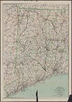
- Creator:
- C.S. Hammond & Company
- Published / Created:
- c1916.
- Call Number:
- 766gmb 1916H
- Container / Volume:
- BRBL_00475
- Image Count:
- 1
- Resource Type:
- Maps, Atlases & Globes
- Found in:
- Beinecke Rare Book and Manuscript Library > Hammond's new road map of Connecticut (Eastern part) / based on the surveys of the United States Geological Survey, United States Coast and Geodetic Survey and the various local surveys, revised and corrected ... C.S. Hammond & Company.
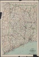
- Creator:
- C.S. Hammond & Company
- Published / Created:
- 1916
- Call Number:
- 766gmb 1916H
- Container / Volume:
- BRBL_00475
- Image Count:
- 1
- Resource Type:
- Maps, Atlases & Globes
- Found in:
- Beinecke Rare Book and Manuscript Library > Hammond's new road map of Connecticut (Western part) / based on the surveys of the United States Geological Survey, United States Coast and Geodetic Survey and the various local surveys, revised and corrected ... C.S. Hammond & Company.
- Creator:
- C.S. Hammond & Company.
- Published / Created:
- ©1913.
- Call Number:
- BrSides Double Folio 2017 10
- Image Count:
- 1
- Resource Type:
- Maps, Atlases & Globes
- Found in:
- Beinecke Rare Book and Manuscript Library > Hammond's new road map of Connecticut [cartographic material] / based on the surveys of the United States Geological Survey, United States Coast and Geodetic Survey and the various local surveys, revised and corrected ... C.S. Hammond & Company.
- Creator:
- United States. Office of Farm Management
- Published / Created:
- 1915
- Call Number:
- 75gce 1915
- Container / Volume:
- BRBL_00410
- Image Count:
- 1
- Resource Type:
- Maps, Atlases & Globes
- Found in:
- Beinecke Rare Book and Manuscript Library > Irrigation map of the United States / engraved and printed by the U.S. Geological Survey ; outline of irrigated areas based upon data collected by the Bureau of the Census, 1910 ; revised by Irrigation Division, Office of Experimental Stations, and by the
- Creator:
- Maryland Geological Survey
- Published / Created:
- 1900
- Call Number:
- 777fb Al53 1900
- Container / Volume:
- BRBL_00504A
- Image Count:
- 3
- Resource Type:
- Maps, Atlases & Globes
- Found in:
- Beinecke Rare Book and Manuscript Library > Map of Allegany County showing the topography and election districts. / Maryland Geological Survey, in cooperation with U.S. Geological Survey.