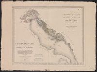
[Atlas nouveau contenant toutes les parties du monde ou sont exactement marques les empires
Image Count:
1
Resource Type:
Maps, Atlases & Globes
Abstract:
Factitious collection of about 549 maps taken from the atlases of the 17th and the beginning of the 18th century, put together with the title "Atlas" and bound in 6 volumes. These volumes originally bore the imprint: Amstelaedamii apvd Reiniervm & Josvam Ottens. Over these words on the title pages of volumes 1-2 and 4-6 is the name of Henrik de Leth who painted them.
Description:
Verso blank.
Subject (Geographic):
British Isles --Maps --Early works to 1800
Subject (Name):
Leth, Hendrik de, 1703-1766, Reiner et Josua Ottens (Firm), Schenck, Peter, 1661-1715, Schenck, Peter, ca. 1698-1752, Valck, G. (Gerard), 1651 or 2-1726, and Wit, Frederik de
Subject (Topic):
Atlases --Early works to 1800
Collection Created:
[A Amsterdam, chez J. Covens & C. Mortier, ca. 1730-ca. 1800]
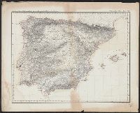
Abteilung II. Oro- und hydrographische Karte der Pyrenäischen Halbinsel, nach Berghaus, Oro- und hydrographische Karte der Pyrenäischen Halbinsel, nach Berghaus, and Platt's grosser Atlas der Erde.
Description:
Relief shown by hachures. and Stamp: Karpinski-von Wieser Map Collection.
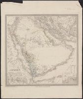
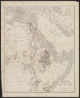
Appears in Allgemeiner Hand-Atlas der Erde und des Himmels nach den best, Prime meridian: Ferro., Relief shown by hachures and spot heights., and Shows physical and ethnographic features, regional and political boundaries, caravan trails, and tribal affiliation.
Subject (Geographic):
Aden (Yemen)--Maps, Arabian Peninsula--Maps, Mecca (Saudi Arabia)--Maps, and Sinai (Egypt)--Maps
Bound in after p. 92., Map folded irregularly., Map has multiple small brown stains on both the recto and verso., Place names in multiple languages including Italian, Latin, Portuguese, and Spanish., and Scale [ca. 1:6,500,000].
Subject (Geographic):
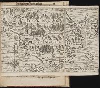
Borneo --Maps --Early works to 1800
Collection Created:
Gedruckt zu Franckfurt / Durch Matthaeum Becker, 1602
Herder, Bartholomä, 1774-1839, lithographer Woerl, Joseph Edmund Woerl, Joseph Edmund. Atlas von Central-Europa
Call Number:
30 1840B
Container / Volume:
BRBL_00031
Image Count:
1
Resource Type:
Maps, Atlases & Globes
Description:
From Woerl's Atlas von Central-Europa, 1830., Imperfect: trimmed along neat line, with loss of marginal data. Dissected and mounted on cloth., Relief shown by hachures., and Title from label on verso.
Subject (Geographic):
Baden-Württemberg (Germany)--Maps, Graubünden (Switzerland)--Maps, Tyrol (Austria)--Maps, and Vorarlberg (Austria)--Maps
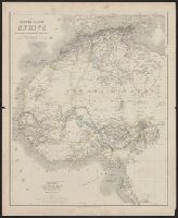
In lower right corner: 57., Relief shown by hachures., and Shows outlines of European possessions and select names and dates of European explorations from 1849 through 1862.
Subject (Geographic):
Africa, Eastern--Maps and Africa, North--Maps
Subject (Name):
Gräf, A. (Adolf), active 1855-1878 and Haubold, G. (Georg), engraver
In lower right corner: 56., Relief shown by hachures., and Shows outlines of European possessions and select names and dates of European explorations from 1850 through 1860.