- Creator:
- Tirion, Isaak
- Published / Created:
- 1750]
- Call Number:
- 40 1760A
- Container / Volume:
- BRBL_00197
- Image Count:
- 1
- Resource Type:
- Maps, Atlases & Globes
- Description:
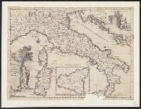
- Appears in Guillaume de l'Isle's Atlante novissimo, vol. 2, pl. 17 (plate only num, Imperfect: Mutilated, with some loss of text. Mounted on linen. Sheet measures 38 x 49 cm. dgvmp2008., Includes scale in Italian miles., and Inset: Il regno di Sicilia.
- Publisher:
- Giambatista Albrizzi q. Girol.,
- Subject (Geographic):
- Italy--Maps--Early works to 1800
- Found in:
- Beinecke Rare Book and Manuscript Library > Carta geografica generale dell' Italia.
You Searched For
1 - 10 of 10
Search Results
2.
- Creator:
- Porcacchi, Thomaso, ca. 1530-1585?
- Published / Created:
- 1576]
- Call Number:
- 855 1576A
- Container / Volume:
- BRBL_00695
- Image Count:
- 2
- Resource Type:
- Maps, Atlases & Globes
- Alternative Title:
- Cuba, Descrittione dell' isola Cuba, and Descrittione dell' isola Cvba
- Description:
- Cross Collection no. 275., From author's L'isole piu famose del mondo, 1576., and Relief shown pictorially.
- Publisher:
- Appresso S. Galignani & G. Porro,
- Subject (Geographic):
- Cuba--Maps--Early works to 1800
- Subject (Name):
- Galignani, Simon, printer, Porcacchi, Thomaso, ca. 1530-1585? Isole piu famose del mondo, and Porro, Girolamo, 1520-1604, printer
- Found in:
- Beinecke Rare Book and Manuscript Library > Cvba.
- Creator:
- Porcacchi, Thomaso, ca. 1530-1585?
- Published / Created:
- 1576]
- Call Number:
- 343 1576B
- Container / Volume:
- BRBL_00683
- Image Count:
- 2
- Resource Type:
- Maps, Atlases & Globes
- Alternative Title:
- Descrittione dell' isola d'Islanda
- Description:
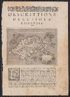
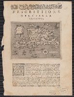
- A variant printing has caption title: Descrittione dell' isola d'Islanda di Thomaso Porcacchi., From author's L'isole piu famose del mondo, descritte da Thomaso Porcacchi ... Venetia: Appresso S. Galignani & G. Por, and Paginated 1-2, with signature A1 on p. 1.
- Publisher:
- Appresso S. Galignani & G. Porro,
- Subject (Geographic):
- Iceland--Maps--Early works to 1800
- Subject (Name):
- Porcacchi, Thomaso, ca. 1530-1585?. Isole piu famose del mondo
- Found in:
- Beinecke Rare Book and Manuscript Library > Islanda [cartographic material].
- Creator:
- Coronelli, Vincenzo, 1650-1718
- Published / Created:
- 1690?]
- Call Number:
- 57 1690
- Container / Volume:
- BRBL_00301
- Image Count:
- 1
- Resource Type:
- Maps, Atlases & Globes
- Description:
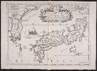
- "Dedicata al Molto Revdo. Pre. Fontaine della compagnia de Gesù Assistente di Francia dal P.M. Coronelli M.C. Cosmografo della Sernma. Republica de Venetia.", "Si uende preso Domenico Padoani sul pont, and Appears in Coronelli's Atlante Veneto, Venice, 1691-6.
- Publisher:
- D. Padoani,
- Subject (Geographic):
- Japan--Maps--Early works to 1800 and Korea--Maps--Early works to 1800
- Subject (Name):
- Coronelli, Vincenzo, 1650-1718. Atlante veneto and Padoani, Domenico
- Found in:
- Beinecke Rare Book and Manuscript Library > Isola del Giapone e penisola de Corea / Vincenzo Coronelli.
- Creator:
- Coronelli, Vincenzo, 1650-1718
- Published / Created:
- 1692-1694?]
- Call Number:
- 56 1692
- Container / Volume:
- BRBL_00734
- Image Count:
- 1
- Resource Type:
- Maps, Atlases & Globes
- Description:
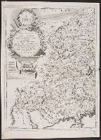
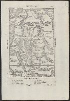
- "Divisa nelle sue provincie e dedicata al Molto Rev. Padre Antonio Baldigiani della Compagnia di Gesú Professore delle matematiche nell' Università Collegio Romano"., "Si uende presso Dom. Padoani sul ponte di Rialto all'insegna della Geografia", Appears in Coronelli's Corso geografico universale., Dedicated to the Jesuit Antonio Baldigiani and decorated with surveying instruments., and Sheet measures 68 x 69 cm. Lanman Collection; dgvmp2008.
- Publisher:
- Vincenzo Coronelli,
- Subject (Geographic):
- China--Maps--Early maps to 1800
- Subject (Name):
- Coronelli, Vincenzo, 1650-1718. Parte orientale della China
- Found in:
- Beinecke Rare Book and Manuscript Library > Parte occidentale della China / dal P.M. Coronelli M.C. cosmografo della serma. rep. di Venetia.
- Creator:
- Gastaldi, Giacomo, ca. 1500-ca. 1565
- Published / Created:
- 1563]
- Call Number:
- 60 1563
- Container / Volume:
- BRBL_00321
- Image Count:
- 1
- Resource Type:
- Maps, Atlases & Globes
- Alternative Title:
- [Africa] prima tavola
- Description:
- From Ramusio's Navigationi et viaggi. 1563., Has watermark., Includes ill. of ships, sea monsters, etc., Oriented with north to the bottom., Relief shown pictorially., and Sheet measures 31 x 43.5 cm. dgvmp2008.
- Publisher:
- s.n.,
- Subject (Geographic):
- Africa--Maps--Early works to 1800
- Subject (Name):
- Ramusio, Giovanni Battista, 1485-1557. Navigazioni e viaggi
- Found in:
- Beinecke Rare Book and Manuscript Library > Prima tavola [Africa].
7.
- Creator:
- Porcacchi, Thomaso, ca. 1530-1585?
- Published / Created:
- 1576]
- Call Number:
- 853 1576A
- Container / Volume:
- BRBL_00694
- Image Count:
- 2
- Resource Type:
- Maps, Atlases & Globes
- Alternative Title:
- Descrittione dell' isola Spagnuola, Descrittione dell' isola Spagnvola, and Spagnuola
- Description:
- From author's L'isole piu famose del mondo, descritte da Thomaso Porcacchi ... Venetia: Appresso S. Galignani & G. Porro, 1576., Paginated 165., and Relief shown pictorially.
- Publisher:
- Appresso S. Galignani & G. Porro,
- Subject (Geographic):
- Hispaniola--Maps--Early works to 1800
- Subject (Name):
- Galignani, Simon, Porcacchi, Thomaso, ca. 1530-1585?. Isole piu famose del mondo, and Porro, Girolamo, 1520-1604
- Found in:
- Beinecke Rare Book and Manuscript Library > Spagnvola.
8.
- Creator:
- Coronelli, Vincenzo, 1650-1718
- Published / Created:
- 1691?]
- Call Number:
- 18 1691
- Container / Volume:
- BRBL_00681
- Image Count:
- 1
- Resource Type:
- Maps, Atlases & Globes
- Description:
- Appears in the author's Atlante Veneto. 1691-1697., Cross collection no. 55. dgvmp2008., Dedicated to Ercole Pepoli., Imperfect: wormholes, with no loss of text., Includes text., Prime meridian: Ferro., and Relief shown pictorially.
- Publisher:
- Domenico Padouani,
- Subject (Geographic):
- Arctic Regions--Maps--Early works to 1800
- Subject (Name):
- Coronelli, Vincenzo, 1650-1718. Atlante veneto, Padoani, Domenico, and Pepoli, Ercole, dedicatee
- Found in:
- Beinecke Rare Book and Manuscript Library > Terre Artiche / descritte dal P.M. Coronelli M.C., cosmografo della sereniss Republica di Venetia.
- Creator:
- Bordon, Benedetto, 1450-1530
- Published / Created:
- 1528?]
- Call Number:
- 57 1528
- Container / Volume:
- BRBL_00300
- Image Count:
- 2
- Resource Type:
- Maps, Atlases & Globes
- Alternative Title:
- [Iaua Maggiore, Sondur, and Condur].
- Description:
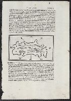
- Appears in Bordon's Libro di Benedetto Bordone nel qual si ragiona de tutte l'isole del mondo. 1528., Ciampagu oriented with north to the right. Iava Maggiore, Sondur, and Condur oriented with north toward the lower right., and Covers Japan, depicted as one isl
- Publisher:
- Nicolo d'Aristotile, detto Zoppino,
- Subject (Geographic):
- Japan--Maps--Early works to 1800 and Java (Indonesia)--Maps--Early works to 1800
- Subject (Name):
- Bordon, Benedetto, 1450-1530. Libro di Benedetto Bordone nel qual si ragiona de tutte l'isole del mondo and Zoppino, Nicolò, fl. 1508-1544
- Found in:
- Beinecke Rare Book and Manuscript Library > [Ciampagu ; Iaua Maggiore, Sondur, and Condur].
10.
- Creator:
- Ramusio, Giovanni Battista, 1485-1557
- Published / Created:
- 155-?]
- Call Number:
- 60 155X
- Container / Volume:
- BRBL_00321
- Image Count:
- 2
- Resource Type:
- Maps, Atlases & Globes
- Description:
- Appears in the author's Delle navigationi et viaggi., Covers Africa, except for the western bulge and southern tip., Has watermark., Includes text on verso., Oriented with north to the bottom., Pg. no. in upper right margin: 261., Relief shown pictorially., and Titl
- Publisher:
- G.B. Ramusio,
- Subject (Geographic):
- Africa--Maps--Early works to 1800
- Subject (Name):
- Ramusio, Giovanni Battista, 1485-1557. Delle navigationi et viaggi
- Found in:
- Beinecke Rare Book and Manuscript Library > [Map of Africa].