Skip to search
Skip to main content
Skip to first result
Search
You Searched For
Extent of Digitization
Completely digitized
Genre
Maps
Language
Italian
New Search
Search Results
Published / Created:
[1860?]
Call Number:
40 P24 1860A
Container / Volume:
BRBL_00213
Image Count:
1
Resource Type:
Maps, Atlases & Globes
Alternative Title:
Atlante geografico dell' Italia.
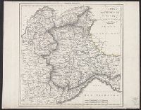
Description:
In upper left margin: Atlante geografico dell' Italia., Inset map of Piacenza with index., and Relief shown by hachures and soundings.
Publisher:
Francesco Vallardi,
Subject (Geographic):
Parma (Italy)--Maps and Piacenza (Italy)--Maps
Subject (Name):
Casa editrice dr. Francesco Vallardi
Found in:
Beinecke Rare Book and Manuscript Library > Carta corografica delle provincie di Parma e Piacenza / V. Stanghi e G. Maina inc. ; G. Pozzi scris.
Published / Created:
[1860?]
Call Number:
40 P24 1860A
Container / Volume:
BRBL_00213
Image Count:
1
Resource Type:
Maps, Atlases & Globes
Alternative Title:
Atlante geografico dell' Italia.
Description:
In upper left margin: Atlante geografico dell' Italia., Inset map of Piacenza with index., and Relief shown by hachures and soundings.
Publisher:
Francesco Vallardi,
Subject (Geographic):
Parma (Italy)--Maps and Piacenza (Italy)--Maps
Subject (Name):
Casa editrice dr. Francesco Vallardi
Found in:
Beinecke Rare Book and Manuscript Library > Carta corografica delle provincie di Parma e Piacenza / V. Stanghi e G. Maina inc. ; G. Pozzi scris.
Published / Created:
ca. 1860?]
Call Number:
40 1858
Container / Volume:
BRBL_00201
Image Count:
8
Resource Type:
Maps, Atlases & Globes
Description:
Legend appears in lower left of sheet 5., Place of publication suggested by longitude value., Sheets numbered with Roman numerals in upper left., and Title appears on sheet 8.
Publisher:
s.n.,
Subject (Geographic):
Italy--Maps
Found in:
Beinecke Rare Book and Manuscript Library > Carta corografica strategica dell' alta Italia alla scala di 1 a 600000.
Published / Created:
[1755?]
Call Number:
71 1755G
Container / Volume:
BRBL_00363
Image Count:
1
Resource Type:
Maps, Atlases & Globes
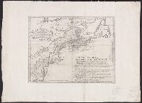
Description:
Italian version of Carte d'une partie de l'Amérique Septentrionale pour servir á l'intelligence du mémoire, London, 1755, delineating the boundary dispute between France and England over Nova Scotia. Shows historical French claims in Acadia. and Watermark.
Publisher:
[publisher not identified],
Subject (Geographic):
Middle Atlantic States--Maps--Early works to 1800, New England--Maps--Early works to 1800, and Nova Scotia--Maps--Early works to 1800
Subject (Name):
Bellin, Jacques Nicolas, 1703-1772. Carte d'une partie de l'Amérique Septentrionale pour servir á l'intelligence du mémoire. Italian
Found in:
Beinecke Rare Book and Manuscript Library > Carta d'una parte dell' America Settentrionale : che serve per ben poter intendere le pretensioni delli Inglesi, esposte ne loro memoriali in occasione della regolazione de limiti con la Francia nell' America svdetta.
Call Number:
402 1829
Container / Volume:
BRBL_00233
Image Count:
1
Resource Type:
Maps, Atlases & Globes
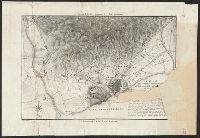
Description:
Description based on imperfect Beinecke Library copy., Imperfect: 3 sheets wanting (eastern sheets, southwestern sheet)., and Relief shown by hachures.
Subject (Geographic):
Lombardy (Italy)--Maps
Found in:
Beinecke Rare Book and Manuscript Library > Carta dei confini delle Provincie Lombarde : ordinata da sua eccellenza il sigr. Conte di Strassoldo, Presidente dell'I.R. Governo della Lombardia, nel 1829.
Creator:
Call Number:
39hc B23 1808
Container / Volume:
BRBL_00192
Image Count:
1
Resource Type:
Maps, Atlases & Globes
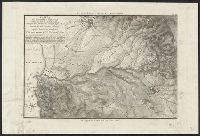
Description:
"Tav. III"--Upper right margin., Imperfect: Mutilated with loss of text., Map to accompany Vacani's Storia delle campagne e degli assedj degl' Italiani, Relief shown by contours., and Title and statement of responsibility based on imperfect Beinecke Library copy.
Subject (Geographic):
Barcelona (Spain)--History, Military--19th century--Maps and Barcelona (Spain)--Maps
Subject (Name):
Vacani, Cammillo. Storia delle campagne e degli assedj degl' Italiani in Ispagna
Subject (Topic):
Peninsular War, 1807-1814--Maps
Found in:
Beinecke Rare Book and Manuscript Library > Carta dei contorni di Barcelona ... / C. Vacani, disegno.
Creator:
Call Number:
39hc T17 1813
Container / Volume:
BRBL_00192
Image Count:
1
Resource Type:
Maps, Atlases & Globes
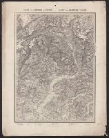
Description:
"Tav. IV"--Upper right margin., Map to accompany Vacani's Storia delle campagne e degli assedj degl' Italiani in Ispagna., and Relief shown by contours.
Subject (Geographic):
Tarragona (Spain : Province)--History, Military--19th century--Maps and Tarragona (Spain : Province)--Maps
Subject (Name):
Vacani, Cammillo. Storia delle campagne e degli assedj degl' Italiani in Ispagna
Subject (Topic):
Peninsular War, 1807-1814--Maps
Found in:
Beinecke Rare Book and Manuscript Library > Carta dei contorni di Tarragona relativa alla Battaglia di Valls nel 1809 ... / C. Vacani, disegno ; L. Antonini, incise.
Published / Created:
[1965?]
Call Number:
377cbf 1865
Image Count:
1
Resource Type:
Maps, Atlases & Globes
Description:
Legend in Italian and German.
Publisher:
J. Wurster u. Comp,
Subject (Geographic):
Ticino (Switzerland)--Maps
Found in:
Beinecke Rare Book and Manuscript Library > Carta del Cantone di Ticino = Karte des Cantons Tessin
Call Number:
401 1849
Container / Volume:
BRBL_00233
Image Count:
1
Resource Type:
Maps, Atlases & Globes
Description:
Hand colored., Meridian: Paris., and Relief shown by hachures.
Subject (Geographic):
Genoa (Italy : Province)--Maps, Piedmont (Italy)--Maps, and Savoy (France and Italy)--Maps
Subject (Name):
Bacler d'Albe, Joseph Albert, 1789-1824
Found in:
Beinecke Rare Book and Manuscript Library > Carta del Piemonte, Savoja e Genovesato / da B. Dalbe.
Branch:v1.61.6 ,Deployed:2024-06-12T09:55:36-04:00