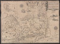
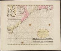
Below title in cartouche: "Met privilegio voor 15 iaaren ao 1687.", Depths shown by soundings., Dutch and French., Inset map: Le partie du Carolina grand point., and Sheet measures 44.3 x 56.7 cm. Cross Collection no. 220.
Publisher:
s.n.],
Subject (Geographic):
Atlantic Coast (South Atlantic States)--Nautical charts--Early works to 1800 and South Carolina--Nautical charts--Early works to 1800
Subject (Topic):
Nautical charts--Atlantic Coast (South Atlantic States)--Early works to 1800 and Nautical charts--South Carolina--Early works to 1800
Exacta et accurata delineatis cum orarum maritimarum tum etjam locorum terrestrium and Waarachtige wtworpinghe ofte afbeeldinge van alle dje custen end landen
Description:
Appears in the author's Itinerario. 1596., Backed with paper., Has watermark., Includes ill., Latin and Dutch., Oriented with north to the left., and Relief shown pictorially.
Publisher:
C. Claesz,
Subject (Geographic):
Southeast Asia--Maps--Early works to 1800
Subject (Name):
Langren, Arnold Florent van, 1580-1644, Langren, Henricus F. ab (Henricus Florentius), ca. 1574-1648, engraver, Linschoten, Jan Huygen van, 1563-1611, and Linschoten, Jan Huygen van, 1563-1611. Itinerario, voyage ofte schipvae
Subject (Topic):
Nautical charts--South China Sea--Early works to 1800 and Nautical charts--Southeast Asia--Early works to 1800
Keulen, Gerard van Keulen, Johannes van, fl. 1726-1753. Nieuwe groote lichtende zee-fakkel
Call Number:
303cea 1680
Container / Volume:
BRBL_00033
Image Count:
1
Resource Type:
Maps, Atlases & Globes
Alternative Title:
New sea map of the whole North Sea and Nouvelle carte marine generale de la Mer du Nord
Description:
Appeared in Joannes van Keulen's De Nieuwe groote, Backed with paper. Sheets measure 61.0 x 52.2 cm or smaller., Includes five bar scales., Relief shown pictorially; depth shown by soundings., and Scale estimated by measurement of degree of latitude.
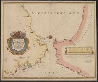
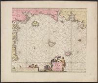
Hand col. Mounted on linen. Stamp on verso: Gift of W. Redmond Cross., Includes text and decorative cartouche with coat of arms., Oriented with north to the left., and Relief shown pictorially. Depths shown by soundings.
Publisher:
And. en Hend. de Leth, op de Beurs Sluys in de Visser,
Subject (Geographic):
Gibraltar, Strait of--Maps--Early works to 1800
Subject (Name):
Aerssen, François van, d. 1740, Leth, Andries de, 1662-1731, and Leth, Hendrik de, 1703-1766
Subject (Topic):
Coasts--Morocco--Maps--Early works to 1800 and Coasts--Spain--Cádiz (Province)--Maps--Early works to 1800
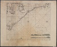
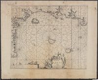
Appears in J. van Keulen's De nieuwe groote lichtende zee-fakkel., Copy 2: Not colored., In bottom right: 7., Includes 2 coastal profiles, 2 insets, and rhumb lines., Oriented with north to the left., and Relief shown pictorially. Depths shown by soundings.
Publisher:
Gerard van Keulen, boek en zeekaart verkooper aen de Nieuwen Brugh,
Subject (Geographic):
Africa, Central--Maps--Early works to 1800 and Coasts--Africa, West--Maps--Early works to 1800
Subject (Name):
Keulen, Johannes van, fl. 1726-1753. Nieuwe groote lichtende zee-fakkel
Subject (Topic):
Nautical charts--Africa, Central--Early works to 1800
Appears in J. van Keulen's De nieuwe groote lichtende zee-fakkel., In bottom right: 7., Includes 2 coastal profiles, 2 insets, and rhumb lines., Oriented with north to the left., and Relief shown pictorially. Depths shown by soundings.
Publisher:
Gerard van Keulen, boek en zeekaart verkooper aen de Nieuwen Brugh,
Subject (Geographic):
Africa, Central--Maps--Early works to 1800 and Coasts--Africa, West--Maps--Early works to 1800
Subject (Name):
Keulen, Johannes van, fl. 1726-1753. Nieuwe groote lichtende zee-fakkel
Subject (Topic):
Nautical charts--Africa, Central--Early works to 1800
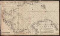
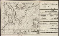
"By Joannes van Keulen, Boek-vercooper en graadboog maecker, by de nieuwe brugh in de gecroonde Lootsman.", "Met prevelegie voor 15 Jaer.", Covers coastal West Af, Depths shown by soundings., Has watermarks., In lower right: 2., and Oriented with north to the left.
Publisher:
Joannes van Keulen,
Subject (Geographic):
Africa, West--Maps--Early works to 1800 and Africa, West--Nautical charts--Early works to 1800
Subject (Topic):
Coasts--Africa, West--Maps--Early works to 1800 and Nautical charts--Africa, West--Early works to 1800
"By Joaunes van Keulen, Boek-verkooper en graet boogh-maker, over de Niewe brug in de gekroonde Loots.", "Met previlegie voor 15, Appeared in Keulen's De groote nieuwe vermeerderde zee-atlas ofte water-waereld., and Includes decorative cartouche and rhumb lines.
Publisher:
Joaunes van Keulen,
Subject (Name):
Keulen, Johannes van, 1654-1715. Groote nieuwe vermeerderde zee-atlas ofte water-waereld
Subject (Topic):
Coasts--Cameroon--Maps--Early works to 1800, Coasts--Equatorial Guinea--Early works to 1800, Coasts--Gabon--Maps--Early works to 1800, Nautical charts--Cameroon--Early works to 1800, and Nautical charts--Equatorial
"By Joaunes van Keulen, Appeared in Keulen's De groote nieuwe vermeerderde zee-atlas ofte water-waereld., Copy 2: Not colored. Sheet measures 60 x 73 cm., Covers coasts of Gabon, Cameroon, and Equatorial Guinea., and Includes decorative cartouche and rhumb lines.
Publisher:
Joaunes van Keulen,
Subject (Name):
Keulen, Johannes van, 1654-1715. Groote nieuwe vermeerderde zee-atlas ofte water-waereld
Subject (Topic):
Coasts--Cameroon--Maps--Early works to 1800, Coasts--Equatorial Guinea--Early works to 1800, Coasts--Gabon--Maps--Early works to 1800, Nautical charts--Cameroon--Early works to 1800, and Nautical charts--Equatorial
"Met prevelegie voor 15 jaer.", Appears in the van Keulen's De groote nieuwe vermeerderde zee-atlas ofte water-waereld., Depths shown by soundings., In bottom right: 8., Includes ornamental cartouche, rhumb lines, and ill., and Oriented with north to the left.
Publisher:
Joannes van Keulen ... aende Nieuwebrugh inde gekroonde Lootsman,
Subject (Name):
Keulen, Johannes van, 1654-1715. Groote nieuwe vermeerderde zee-atlas ofte water-waereld
Subject (Topic):
Coasts--Angola--Maps--Early works to 1800 and Nautical charts--Angola--Early works to 1800