Skip to search
Skip to main content
Skip to first result
Search
You Searched For
Extent of Digitization
Completely digitized
Format
cartographic
Language
French
New Search
Search Results
Creator:
Published / Created:
[between 1920 and 1940?]
Call Number:
400 R66 1920
Container / Volume:
BRBL_00233
Image Count:
1
Resource Type:
Maps, Atlases & Globes
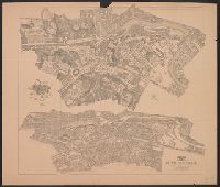
Description:
Map and aerial view of Rome., Oriented with north to the lower right., and Relief shown by hachures and pictorially.
Publisher:
[publisher not identified],
Subject (Geographic):
Rome (Italy)--Antiquities--Maps, Rome (Italy)--Antiquities--Pictorial works, Rome (Italy)--Maps, and Rome (Italy)--Pictorial works
Subject (Topic):
Geography, Ancient--Maps
Found in:
Beinecke Rare Book and Manuscript Library > Rome imperiale (IVe siècle ap. J.C.) / par P. Bigot.
Creator:
Published / Created:
1943
Call Number:
38 R75 1943
Container / Volume:
BRBL_00165
Image Count:
1
Resource Type:
Maps, Atlases & Globes
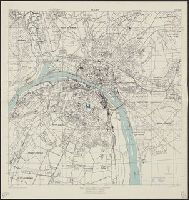
Alternative Title:
France 1:12,500 and Series M961
Description:
"3-43.", "Copied from a French map, 1:10,000, Plan de la ville de Rouen, 1933.", "First edition 1943.", Most streets and some buildings are named., Nord de guerre zone grid., and Street names and some points of interest in French.
Publisher:
Army Map Service, U.S. Army,
Subject (Geographic):
Rouen (France)--Maps
Found in:
Beinecke Rare Book and Manuscript Library > Rouen, city plan [cartographic material] / prepared under the direction of the Chief of Engineers, U.S. Army, 1943.
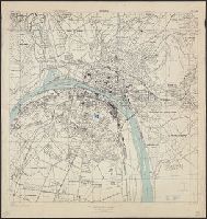
Creator:
Published / Created:
1943
Call Number:
38 R75 1943
Container / Volume:
BRBL_00165
Image Count:
1
Resource Type:
Maps, Atlases & Globes
Alternative Title:
France 1:12,500 and Series M961
Description:
"3-43.", "Copied from a French map, 1:10,000, Plan de la ville de Rouen, 1933.", "First edition 1943.", Most streets and some buildings are named., Nord de guerre zone grid., and Street names and some points of interest in French.
Publisher:
Army Map Service, U.S. Army,
Subject (Geographic):
Rouen (France)--Maps
Found in:
Beinecke Rare Book and Manuscript Library > Rouen, city plan [cartographic material] / prepared under the direction of the Chief of Engineers, U.S. Army, 1943.
Published / Created:
1915
Call Number:
3361cbf R758 1915
Container / Volume:
BRBL_00088
Image Count:
1
Resource Type:
Maps, Atlases & Globes
Publisher:
[Publiée par le Dépot de la Guerre,]
Subject (Geographic):
Roeselare (West Flanders, Belgium)--Maps
Found in:
Beinecke Rare Book and Manuscript Library > Roulers.
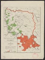
Published / Created:
1919]
Call Number:
11hcf 1919B-20-3
Container / Volume:
BRBL_00010P
Image Count:
1
Resource Type:
Maps, Atlases & Globes
Description:
"S.G. le 2.4.19" and Legend indicates "Frontières proposées (Proposed boundaries)"
Publisher:
s.n.,
Subject (Geographic):
Romania--Maps
Subject (Topic):
World War, 1914-1918--Romania--Maps
Found in:
Beinecke Rare Book and Manuscript Library > Roumanie = Rumania.
Published / Created:
1919]
Call Number:
11hcf 1919B-20-2
Container / Volume:
BRBL_00010P
Image Count:
1
Resource Type:
Maps, Atlases & Globes
Description:
"S.G.A. le 29 Mars 1919." and Legend indicates "Revendications de la Délégation Roumaine, Frontières de 1914, Propositions de la Commission des Affaires Roumaines, and Frontières nouvelles d'Etats voisins."
Publisher:
s.n.,
Subject (Geographic):
Romania--Maps
Subject (Topic):
World War, 1914-1918--Romania--Maps
Found in:
Beinecke Rare Book and Manuscript Library > Roumanie.
Published / Created:
1919]
Call Number:
11hcf 1919B-20-1
Container / Volume:
BRBL_00010P
Image Count:
1
Resource Type:
Maps, Atlases & Globes
Description:
"Imprimé le 21 Mars 1919." and Legend indicates "Revendications de la Délégation Roumaine, Frontières de 1914, and Propositions de la Commission des Affaires Roumaines."
Publisher:
s.n.,
Subject (Geographic):
Romania--Maps
Subject (Topic):
World War, 1914-1918--Romania--Maps
Found in:
Beinecke Rare Book and Manuscript Library > Roumanie.
Creator:
Published / Created:
1943, 1944 printing.
Call Number:
38 R81 1944
Container / Volume:
BRBL_00165
Image Count:
1
Resource Type:
Maps, Atlases & Globes
Alternative Title:
France 1:7,350, Geographical Section, General Staff ; no. 4234, GSGS (Series) ; 4234., and Royan, plan of town
Description:
"First A.M.S. ed., 1943.", "First G.S.G.S. ed., 1943.", "Grid provisional. Lambert (zone II) grid.", "I-44.", "War Office 1943.", Important streets are named; key to points of interest in margin., and Major street names and some buildings in French.
Publisher:
Army Map Service, U.S. Army, and War Office ;
Subject (Geographic):
Royan (France)--Maps
Found in:
Beinecke Rare Book and Manuscript Library > Royan [cartographic material] : plan of town / compiled and drawn by Inter Service Topographical Dept. ; produced under the Superintendence of Vice-Admiral John Edgell, hydrographer.
Branch:v1.61.6 ,Deployed:2024-06-12T09:55:19-04:00