Anville, Jean Baptiste Bourguignon d', 1697-1782 Compagnie des Indes Jefferys, Thomas, d. 1771, creator Kitchin, Thomas, d. 1784 Robert Laurie and James Whittle Sayer, Robert, 1725-1794
Published / Created:
1789 January 1
Call Number:
1982 Folio 10
Image Count:
1
Description:
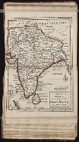
Also appeared in Kitchin's General atlas describing the whole universe. London : Printed for Robert Sayer, [1780]., Has illustrated cartouche and includes text., No. 36 of 43 maps bound together in composite atlas., Norwich, O.I. Norwich's maps of Africa., Prime meridians: Ferro and London., Relief shown pictorially; depths by soundings., Scale [ca. 1:1,850,000]., and This map is copied from an original drawn by Monsr. D'Anville at the expense of the French East India Company, & published at Paris. The country thorough [sic] which the R. Senegal runs has been improved & corrected from a large & curious survey of that river found in the Fort of Senegal.
Publisher:
Printed for by Robert Sayer
Subject (Geographic):
Africa, West --Maps --Early works to 1800
Subject (Topic):
Coasts --Africa, West --Maps --Early works to 1800
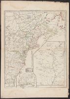
"This map is copied from an original drawn by Monsr. D'Anville ... & published at Paris in 1751. But since the Peace of 1762, that map has been supressed [sic] ... ", Includes descriptive notes,, Prime meridians: Ferro and London., and Relief shown pictorially.
Publisher:
Printed for Robert Sayer in Fleet Street & Thomas Jefferys in the Strand,
Subject (Geographic):
Africa, West--Maps--Early works to 1800, Coasts--Africa, West--Maps--Early works to 1800, and Gambia--Colonization--Maps--Early works to 1800
Subject (Name):
Anville, Jean Baptiste Bourguignon d', 1697-1782 and Sayer, Robert, 1725-1794
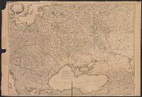
"This map is copied from an original drawn by Monsr. D'Anv, Also appeared in Kitchin's General atlas describing the whole universe. London : Printed for Robert Sayer, [1780]., Prime meridians: Ferro and London., and Relief shown pictorially; depths by soundings.
Publisher:
Printed for Robert Sayer,
Subject (Geographic):
Africa, West--Maps--Early works to 1800
Subject (Name):
Abbot, Charles,--Baron Colchester,--1757-1829--Bookplate, Anville, Jean Baptiste Bourguignon d', 1697-1782, Kitchin, Thomas, d. 1784. General atlas describing the whole universe, and Robert Laurie and James Whittle
Clumnitz Chateau, 7 x 9., Einbogen, Chateau de Brandeis, Budweiss, Eger, Kolin, Leutmaritz, Pilsen, Thabor., Insets: Prag, Ville Capitale, ca 1:45,000, 11 x 15., and Koniggratz [Hradec Králové], 7 x 9.
Publisher:
Chez le Sr. le Rouge,
Subject (Geographic):
Bohemia (Czech Republic)--Maps--Early works to 1800