Skip to search
Skip to main content
Skip to first result
Search
You Searched For
Date
-
Repository
Beinecke Rare Book and Manuscript Library
Genre
Maps
Found In
Beinecke Rare Book and Manuscript Library
New Search
Search Results
Published / Created:
1866
Call Number:
75 1866H
Container / Volume:
BRBL_00403
Image Count:
1
Resource Type:
Maps, Atlases & Globes
Publisher:
U.S. Coast Survey Office,
Subject (Geographic):
United States--Maps
Found in:
Beinecke Rare Book and Manuscript Library > [United States] / drawn by A. Lindenkohl ; Chas. G. Krebs, Litho.
Published / Created:
[1920?].
Call Number:
75 1920
Container / Volume:
BRBL_00407A
Image Count:
2
Resource Type:
Maps, Atlases & Globes
Description:
Various information on borders; shows time zones. and Verso: Central part city of Washington and other data, etc.
Publisher:
Rand, McNally & Co.,
Subject (Geographic):
United States--Maps
Found in:
Beinecke Rare Book and Manuscript Library > [United States] / printed by Rand McNally & Company for free distribution through the newspapers represented by Frederic J. Haskin ; photographs by Harris & Ewing.
Published / Created:
c1902.
Call Number:
75gme 1915
Container / Volume:
BRBL_00414A
Image Count:
1
Resource Type:
Maps, Atlases & Globes
Description:
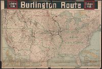
Insets of U.S. Possessions.
Publisher:
Poole Bros.,
Subject (Geographic):
United States--Maps
Found in:
Beinecke Rare Book and Manuscript Library > [United States] Burlington Route / Burlington R.R.
Published / Created:
1888
Call Number:
WA MSS S-1306
Collection Title:
Emmons family papers 1821-1925
Container / Volume:
Folder 367
Image Count:
1
Abstract:
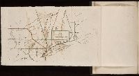
Manuscript map with descriptive notes
Description:
Map tipped in to ship's log book: Cruise of the U.S.S. Pinta / Inland Passage / Alaskan Waters / 1888
Subject (Geographic):
Klawock (Alaska)
Found in:
Beinecke Rare Book and Manuscript Library > [Untitled manuscript map depicting Klawack, Alaska including cannery, mission, and geographical features]
Published / Created:
1774
Call Number:
Pequot Sm95
Collection Title:
An examination of the Connecticut claim to lands in Pennsylvania : with an appendix, containing
Image Count:
1
Description:
Between p. 30-31
Subject (Geographic):
Connecticut., Massachusetts., and Rhode Island
Subject (Topic):
Susquehanna Claim, 1753-1808
Collection Created:
Philadelphia : Printed by J. Crukshank, 1774
Found in:
Beinecke Rare Book and Manuscript Library > [Untitled map depicting southern New England and the coastline]
Call Number:
Taylor 58
Collection Title:
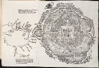
Praeclara Ferdinadi. Cortesii de noua maris Oceani Hyspania narratio ... Carolo Romanoru imperatori
Image Count:
1
Description:
Preceding Argumentum Libri. and Teaching resource: Professor John Mack Faragher, History 141: The American West.
Subject (Geographic):
Mexico City (Mexico) and Mexico --History --Conquest, 1519-1540
Subject (Name):
Savorgnano, Pietro
Collection Created:
Norimberga, 1524
Found in:
Beinecke Rare Book and Manuscript Library > [Untitled map of Tenochtitlan]
Published / Created:
[1808]
Call Number:
In W890 Zz808
Collection Title:
The history of the rise, progress, and accomplishment of the abolition of the African slave-trade
Image Count:
1
Resource Type:
Maps, Atlases & Globes
Description:
Autographed presentation copy to Mrs. Elizabeth Cookson from S.T. Coleridge; on fly-leaf at front of v.1 is Mrs. Wordsworths manuscript copy of her husbands sonnet, "To Thos. Clarkson, on the final passing of the bill for the abol and Folded map facing p. 259
Subject (Topic):
Slave trade. and Slavery
Collection Created:
London : Longman, Hurst, Rees, and Orme, 1808
Found in:
Beinecke Rare Book and Manuscript Library > [Untitled map of abolition of the slave trade]
Creator:
Published / Created:
[1739?]
Call Number:
1973 folio 44
Collection Title:
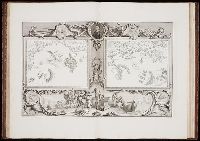
Plan de Paris commence l’annee 1734. Dessine et gravesous les ordres de Messire Michel Etienne
Image Count:
1
Resource Type:
Maps, Atlases & Globes
Description:
Consists of 20 numbered sectional plans of Paris. and Scale about 1:1800.
Subject (Geographic):
Paris (France) --Maps
Subject (Topic):
Architecture --France --Paris
Collection Created:
[Paris? 1739?]
Found in:
Beinecke Rare Book and Manuscript Library > [Untitled sectional plan of Paris]
Creator:
Published / Created:
[1739?]
Call Number:
1973 folio 44
Collection Title:
Plan de Paris commence l’annee 1734. Dessine et grave sous les ordres de Messire Michel Etienne
Image Count:
1
Resource Type:
Maps, Atlases & Globes
Description:
Consists of 20 numbered sectional plans of Paris. and Scale about 1:1800.
Subject (Geographic):
Jardin des Tuileries (Paris, France), Paris (France) --Maps, and Tuileries Palace (Paris, France)
Subject (Topic):
Architecture --France --Paris
Collection Created:
[Paris? 1739?]
Found in:
Beinecke Rare Book and Manuscript Library > [Untitled sectional plan of Paris]
Creator:
Published / Created:
1739
Call Number:
BBy33 44y
Collection Title:
The tapestry hangings of the House of lords representing the several engagements between the
Image Count:
1
Resource Type:
Books, Journals & Pamphlets
Abstract:
"An account of the Spanish Invasion in the year 1588"
Subject (Geographic):
Great Britain--History, Military--1485-1603
Collection Created:
London, 1739[/40] : Sold by J. Pine in Old Bond street near Picadilly
Found in:
Beinecke Rare Book and Manuscript Library > [Untitled, unnumbered pl. depicting Dorsetshire, Hampshire, the Isle of Wight, the English and Spanish Naval fleets]
Branch:v1.61.8 ,Deployed:2024-06-20T11:14:55-04:00