Lowitz, G. M. (George Moritz), 1722-1774, cartographer.
Call Number:
11 1746A
Image Count:
1
Resource Type:
Maps, Atlases & Globes
Alternative Title:
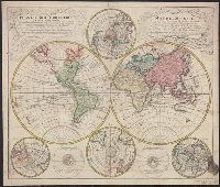
Mappe-monde qui représente les deux hemisphères savoir celui de l'orient et celui de l'occident, tirée des quatre cartes générales de feu M. le profess. Hasius and Planiglobii terrestris mappa vniversalis
Description:
Includes color illustrations, 4 ancillary maps showing poles, and 2 diagrams.
Subject (Name):
Hase, Johann Matthias, 1684-1742. and Homann Erben (Firm), publisher.
Subject (Topic):
Religion--Maps--Early works to 1800. and World maps--Early works to 1800.