Search
You Searched For
Search Results
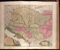
- Creator:
- Schenk, Peter, 1660-1718 or 1719.
- Published / Created:
- 1705
- Call Number:
- 1973 Folio 18
- Image Count:
- 1
- Resource Type:
- Maps, Atlases & Globes
- Found in:
- Beinecke Rare Book and Manuscript Library > Regnorum Hungariae, Dalmatiae, Croatiae, Sclavoniae, Bosniae, Serviae, et Principatus Transylvaniae typus accuratior et plane novus [cartographic material] / editore Petro Schenck caelatur.
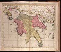
- Creator:
- Valck, G. (Gerard), 1651 or 1652-1726.
- Published / Created:
- [ca. 1702?]
- Call Number:
- 1973 Folio 18
- Image Count:
- 1
- Resource Type:
- Maps, Atlases & Globes
- Found in:
- Beinecke Rare Book and Manuscript Library > Regnum Moreae accuratissime divisum in Provincias Saccaniam, Tzaconiam, Caliscopium et Ducatum Clarensae, una cum Insulis Cephalonia, Zacyntho, Cythera, Aegina et Sidra [cartographic material].
- Creator:
- Schenk, Peter, 1660-1718 or 1719.
- Published / Created:
- 1706?]
- Call Number:
- 1973 Folio 18
- Image Count:
- 1
- Resource Type:
- Maps, Atlases & Globes
- Found in:
- Beinecke Rare Book and Manuscript Library > S. Imperium Romano-Germanicum oder Teutschland mit seinen angrantzenden Konigreichen und Provincien [cartographic material] / aussgegeben durch Petrus Schenk ; mit Privilegie derer H. H. Staten General des Vereinigten Niederland.
- Creator:
- Schenk, Peter, 1660-1718 or 1719.
- Published / Created:
- 1704
- Call Number:
- 1973 Folio 18
- Image Count:
- 1
- Resource Type:
- Maps, Atlases & Globes
- Found in:
- Beinecke Rare Book and Manuscript Library > Septendecim provinciae Germaniae inferioris [cartographic material] : uti sunt sub potestate regum Franciae, et Hispaniae, ordinumque generalium provinciarum unitarum , una cum episcopatibus Monasteriensi, Coloniensi, Leodiensi, et Cameracensi : XVII provinciae latae sunt 88 et longae 60 miliaria Gallica, atque una complent 4928 miliaria quadrata, in iis inveniuntur 216 urbes et 6000 pagi / P. Schenk exc.
- Creator:
- Valck, G. (Gerard), 1651 or 1652-1726.
- Published / Created:
- after 1705]
- Call Number:
- 1973 Folio 18
- Image Count:
- 1
- Resource Type:
- Maps, Atlases & Globes
- Found in:
- Beinecke Rare Book and Manuscript Library > Status Ecclesiasticus, magnus ducatus Florentiae, et resp. Lucae [cartographic material] : complectens ducatus Urbini, Spoleti, Braciani et Castri. marchion. Anconae, urbis ditiones Romam, patrimonium S. Petri, Orvietum, Florentiam, Pisam et Senam : cum supra et subjacentibus regionibus / fecerunt et ediderunt Gerardus et Leonardus Valk.
- Creator:
- Husson, Pieter, 1678-1733.
- Published / Created:
- [1715]
- Call Number:
- 1973 Folio 18
- Image Count:
- 1
- Resource Type:
- Maps, Atlases & Globes
- Found in:
- Beinecke Rare Book and Manuscript Library > Strahlsundt investi le 15 juillet 1715 [cartographic material] / P.V. Cab, fect.
- Creator:
- Valck, G. (Gerard), 1651 or 1652-1726.
- Published / Created:
- ca. 1702?]
- Call Number:
- 1973 Folio 18
- Image Count:
- 1
- Resource Type:
- Maps, Atlases & Globes
- Found in:
- Beinecke Rare Book and Manuscript Library > Sueciae magnae, totius orbis regni antiquissimi, hodierna in sex principales suas partes : Gothiam nempe, Sueciam propriam sive stricté sumptam, Nordlandiam, Finniam, Ingriam, Livoniam earundemq[ue] subdivisionum, ac adjacentium insularum geographica distinctio / ex optimis auctorum descriptionibus collecta, per Geo. et Leo. Valk.
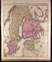
- Creator:
- Schenk, Peter, 1660-1718 or 1719.
- Published / Created:
- ca. 1700?]
- Call Number:
- 1973 Folio 18
- Image Count:
- 1
- Resource Type:
- Maps, Atlases & Globes
- Found in:
- Beinecke Rare Book and Manuscript Library > Superioris atque inferioris Alsatiae tabula perquam accurata et exacta [cartographic material] : proximis regionibus Iucunde huic insertis, annexisque / ex conatibus P. Schenk.
- Creator:
- Schenk, Peter, 1660-1718 or 1719.
- Published / Created:
- ca. 1700?]
- Call Number:
- 1973 Folio 18
- Image Count:
- 1
- Resource Type:
- Maps, Atlases & Globes
- Found in:
- Beinecke Rare Book and Manuscript Library > Tabula nova atque exacta Westphaliae finitimas quoque ditiones prafecturas et satrapias [cartographic material] / eleganter comprehendens, conante Petro Schenck.
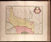
- Creator:
- Blaeu, Joan, 1596-1673, cartographer.
- Published / Created:
- 164-?]
- Call Number:
- 1973 Folio 18
- Image Count:
- 1
- Resource Type:
- Maps, Atlases & Globes
- Found in:
- Beinecke Rare Book and Manuscript Library > Territorio di Cremona [cartographic material].