Search
You Searched For
Search Results
- Creator:
- Jefferys, Thomas, d. 1771
- Published / Created:
- [1759]
- Call Number:
- 1977 Folio 177
- Image Count:
- 2
- Resource Type:
- Maps, Atlases & Globes
- Found in:
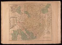
- Beinecke Rare Book and Manuscript Library > A map of the King of Great Britain's Dominions in Germany, or, The Electorate of Brunswick-Lunenburg with its dependencies [cartographic material] : containing the Dutchies of Lunenburg, Calenberg, Grunbenhagen, Lauenburg, Bremen & Verden, and the countie
- Creator:
- Jefferys, Thomas, d. 1771
- Published / Created:
- 175-?]
- Call Number:
- 1977 Folio 177
- Image Count:
- 2
- Resource Type:
- Maps, Atlases & Globes
- Found in:
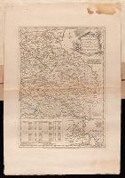
- Beinecke Rare Book and Manuscript Library > A map of the circle of Westphalia comprehending the bishopricks of Liege, Munster, Paderborn & Osnabrug, the dutchies of Westphalia, Cleves, Juliers, Berg & Verden with the principalities of Minden & East Friesland and the counties of Mark, Ravensberg, Ol
- Creator:
- Hoüel, Jean-Pierre-Laurent, 1735-1813
Jefferys, Thomas, d. 1771
- Published / Created:
- [1768]
- Call Number:
- 1977 Folio 177
- Image Count:
- 2
- Resource Type:
- Maps, Atlases & Globes
- Found in:
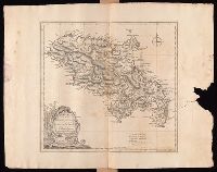
- Beinecke Rare Book and Manuscript Library > Martinico, one of the Caribbee Islands in the West Indies subject to the French / [cartographic material] / according to the observations of Mr. Houel engineer ; by Thos. Jefferys, geographer to His Royal Highness the Prince.
- Creator:
- Jefferys, Thomas, d. 1771
- Published / Created:
- Oct. 28, 1756.
- Call Number:
- 1977 Folio 177
- Image Count:
- 3
- Resource Type:
- Maps, Atlases & Globes
- Found in:
- Beinecke Rare Book and Manuscript Library > The routs of the Prussian Armies into Bohemia [cartographic material] : with the post roads & distances from the original map publish'd at Berlin / by Thos. Jefferys ...
- Creator:
- Bowen, Emanuel, d. 1767
Jefferys, Thomas, d. 1771
- Published / Created:
- 1758
- Call Number:
- 1977 Folio 177
- Image Count:
- 3
- Resource Type:
- Maps, Atlases & Globes
- Found in:
- Beinecke Rare Book and Manuscript Library > The seat of war on the coast of France : being a new chart of the coasts of Holland, Flanders, France, Spain & Portugal, with the adjacent Islands, part of Barbary, England and Ireland / drawn from the latest surveys, and regulated by astronomical observa