Skip to search
Skip to main content
Skip to first result
Search
You Searched For
Call Number
1982 Folio 10
Search Results
Creator:
Published / Created:
May 20th, 1774.
Call Number:
1982 Folio 10
Image Count:
1
Alternative Title:
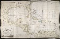
Chart of the West Indies
Description:
BEIN 85 1774A: Sheet measures 75 x 118.2 cm.
Publisher:
Capt. Speer
Subject (Geographic):
Caribbean Area and West Indies
Found in:
Beinecke Rare Book and Manuscript Library > To His Royal Highness. George Augustus Frederick. Prince of Wales &c. &c. &c. this chart of the West Indies is humbly inscribed by His Royal Highness faithful & obedient servant Joseph Smith Speer, Thos. Bowen sculpt
Creator:
Published / Created:
Octr. 24th, 1787.
Call Number:
1982 Folio 10
Image Count:
1
Alternative Title:
Map of the present seat of war, between the Russians, Poles, and Turk
Description:
BEIN 1982 Folio 10: Includes paste-on addition to northwestern sheet depicting Bosnia, Herzegovina, and the Dalmatian Coast. Armorial bookplate: Charles Abbot. No. 25 of 42 maps bound together.
Publisher:
Wm. Faden
Subject (Geographic):
Black Sea and Russia
Subject (Topic):
Russo-Turkish War, 1787-1792
Found in:
Beinecke Rare Book and Manuscript Library > To his excellency the Count of Czernichew, commander in chief of her Majesty the Empress of all the Russia's fleet and gallies ... : map of the present seat of war, between the Russians, Poles, and Turks is most humbly inscribed ...
Call Number:
1982 Folio 10
Image Count:
1
Description:
Armorial bookplate: Charles Abbot. Karpinski 5234.
Subject (Topic):
Atlases, English
Found in:
Beinecke Rare Book and Manuscript Library > [Composite atlas of the world].