Skip to search
Skip to main content
Skip to first result
Search
You Searched For
Repository
Beinecke Rare Book and Manuscript Library
Publication Place
Lutetiae
Call Number
1983 Folio 19
New Search
Search Results
Creator:
Published / Created:
1651
Call Number:
1983 Folio 19
Collection Title:
[Atlas factice of 96 maps by Blaeu, Visscher, Jansson, Hondius and others]
Image Count:
1
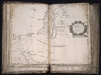
Description:
Imperfect: trimmed, with some loss of text and graticule; torn along fold, with partial loss of text. Sheet measures 40.6 x 53.2 cm. No. 18 of 92 maps bound together.
Publisher:
Sumptibus Petri Mariette ...
Subject (Geographic):
Jerusalem --History --Maps --Early works to 1800, Palestine --History --638-1917 --Maps, and Palestine --Maps --Early works to 1800
Found in:
Beinecke Rare Book and Manuscript Library > Pinax geographicus Patriarchatus Hierosolymitani ... / auctore Ph. de la Rue ... ; J. Sommer sculp
Creator:
Published / Created:
1651
Call Number:
1983 Folio 19
Collection Title:
[Atlas factice of 96 maps by Blaeu, Visscher, Jansson, Hondius and others]
Image Count:
1
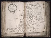
Description:
Imperfect: torn along fold, with partial loss of text. Sheet measures 40.9 x 54 cm. No. 19 of 92 maps bound together.
Publisher:
Sumptibus Petri Mariette ...
Subject (Geographic):
Palestine --Historical geography --Maps --Early works to 1800
Subject (Name):
Bible. O.T. --Geography --Maps --Early works to 1800
Found in:
Beinecke Rare Book and Manuscript Library > Regnum Judeorum in filios Herodis magni per Tetrarchias diuisum ad tempora Christi domini ... / auctore Ph. de la Rue ... ; Jean Sommer, sculpsit
Creator:
Published / Created:
[1651]
Call Number:
1983 Folio 19
Collection Title:
[Atlas factice of 96 maps by Blaeu, Visscher, Jansson, Hondius and others]
Image Count:
1
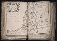
Description:
Imperfect: torn near fold, with no loss of text. Sheet measures 39.5 x 54.3 cm. No. 20 of 92 maps bound together.
Publisher:
Sumptibus Petri Mariette ...
Subject (Geographic):
Palestine --Historical geography --Maps --Early works to 1800
Subject (Name):
Bible. O.T. --Geography --Maps --Early works to 1800
Found in:
Beinecke Rare Book and Manuscript Library > Regnum Salomonicum, seu, Tabula digesta ad Libros Judicum, Regum, Paral, et Prophetarum per Eparchias XII Mox Regna duo : Cum Privil. Regis Christ. / Auctore Ph. de la Rue ...
Creator:
Published / Created:
[1651]
Call Number:
1983 Folio 19
Collection Title:
[Atlas factice of 96 maps by Blaeu, Visscher, Jansson, Hondius and others]
Image Count:
1
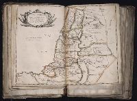
Description:
Imperfect: mutilated near fold, with some loss of text. Hand col. Sheet measures 40.2 x 52.8 cm. No. 21 of 92 maps bound together.
Publisher:
Apud Petrum Mariette ...
Subject (Geographic):
Palestine --Historical geography --Maps --Early works to 1800
Subject (Name):
Bible. O.T. --Geography --Maps --Early works to 1800
Found in:
Beinecke Rare Book and Manuscript Library > Terra Promissa in sortes seu tribvs XII distincta seu tabula ad Librum Iosve / auctore Ph. de la Rue ...
Branch:v1.61.6 ,Deployed:2024-06-12T09:55:37-04:00