Skip to search
Skip to main content
Skip to first result
Search
You Searched For
Repository
Beinecke Rare Book and Manuscript Library
Call Number
1983 Folio 19
New Search
Search Results
Creator:
Published / Created:
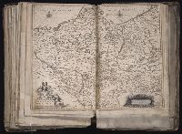
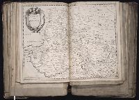
[ca. 1633]
Call Number:
1983 Folio 19
Collection Title:
[Atlas factice of 96 maps by Blaeu, Visscher, Jansson, Hondius and others]
Image Count:
1
Description:
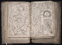
Imperfect: mutilated along fold, with some loss of text; bar scale cut out and replaced in ms. Reinforced along edges with printed waste. Sheet measures 39.1 x 50.4 cm. No. 78 of 92 maps bound together. and Numbered 84 [80, cancelled] on verso.
Publisher:
Excudebat Ioannes Ianssonius
Subject (Geographic):
Brandenburg (Germany : Landkreis) --Maps --Early works to 1800s, Mecklenburg-Vorpommern (Germany) --Maps --Early works to 1800, and Pomerania (Poland and Germany) --Maps --Early works to 1800
Collection Created:
[1556-1680]
Found in:
Beinecke Rare Book and Manuscript Library > Brandeburgum Marchionatus, cum Ducatibus Pomeraniae et Meklenburgi
Creator:
Published / Created:
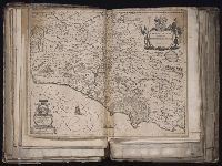
[164-?]
Call Number:
1983 Folio 19
Collection Title:
[Atlas factice of 96 maps by Blaeu, Visscher, Jansson, Hondius and others]
Image Count:
1
Description:
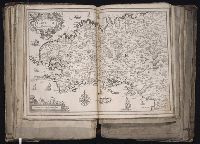
Imperfect: torn along fold, with some loss of text.. Sheet measures 38.9 x 49.2 cm. No. 15 of 92 maps bound together.
Publisher:
Willem Janszoon Blaeu
Subject (Geographic):
Lazio (Italy) --Maps --Early works to 1800
Subject (Name):
Blaeu, Cornelis, dedicator and Dal Pozzo, Cassiano, 1588-1657, dedicatee
Collection Created:
[1556-1680]
Found in:
Beinecke Rare Book and Manuscript Library > Campagna di Roma, olim Latium : patrimonio di S. Pietro
Creator:
Published / Created:
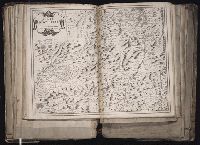
1643
Call Number:
1983 Folio 19
Collection Title:
[Atlas factice of 96 maps by Blaeu, Visscher, Jansson, Hondius and others]
Image Count:
1
Description:
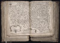
Sheet measures 39.1 x 51.3 cm. Reinforced along lower edges with manuscript waste. No. 37 of 92 maps bound together.
Publisher:
[Pierre Mariette]
Subject (Geographic):
Auvergne (France) --Maps --Early works to 1800
Collection Created:
[1556-1680]
Found in:
Beinecke Rare Book and Manuscript Library > Carte d'Auuergne
Creator:
Published / Created:
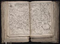
[ca. 1634]
Call Number:
1983 Folio 19
Collection Title:
[Atlas factice of 96 maps by Blaeu, Visscher, Jansson, Hondius and others]
Image Count:
1
Description:
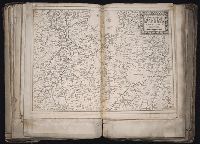
Sheet measures 39.1 x 51.3 cm. Reinforced along lower edges with manuscript waste. No. 38 of 92 maps bound together.
Publisher:
Christophe Tassin
Subject (Geographic):
Berry (France) --Maps --Early works to 1800
Found in:
Beinecke Rare Book and Manuscript Library > Carte de Berry
Creator:
Published / Created:
[1634]
Call Number:
1983 Folio 19
Collection Title:
[Atlas factice of 96 maps by Blaeu, Visscher, Jansson, Hondius and others]
Image Count:
1
Description:
Imperfect: wormhole in center crease, with some loss of text. Reinforced along lower edges with manuscript waste. Sheet measures 38.8 x 51.6 cm. No. 34 of 92 maps bound together.
Publisher:
Christophe Tassin
Subject (Geographic):
Bresse (France : Region) --Maps --Early works to 1800
Found in:
Beinecke Rare Book and Manuscript Library > Carte de Bresse
Creator:
Published / Created:
[1634]
Call Number:
1983 Folio 19
Collection Title:
[Atlas factice of 96 maps by Blaeu, Visscher, Jansson, Hondius and others]
Image Count:
1
Description:
Imperfect: wormhole in center crease, with no loss of text. Reinforced along lower edges with manuscript waste. Sheet measures 38.9 x 51.5 cm. No. 33 of 92 maps bound together.
Publisher:
Christophe Tassin
Subject (Geographic):
Brittany (France) --Maps --Early works to 1800
Found in:
Beinecke Rare Book and Manuscript Library > Carte de Bretagne
Creator:
Published / Created:
[1634?]
Call Number:
1983 Folio 19
Collection Title:
[Atlas factice of 96 maps by Blaeu, Visscher, Jansson, Hondius and others]
Image Count:
1
Description:
Sheet measures 39 x 51.5 cm. Reinforced along lower edges with manuscript waste. No. 40 of 92 maps bound together.
Publisher:
s.n
Subject (Geographic):
Dauphine (France) --Maps --Early works to 1800
Found in:
Beinecke Rare Book and Manuscript Library > Carte de Dauphine
Creator:
Published / Created:
1645
Call Number:
1983 Folio 19
Collection Title:
[Atlas factice of 96 maps by Blaeu, Visscher, Jansson, Hondius and others]
Image Count:
1
Description:
Numbered 61 on verso. and Reinforced along lower edges with manuscript waste. Sheet measures 39.1 x 51.3 cm. No. 57 of 92 maps bound together.
Publisher:
N. Berey proche les Augustins
Subject (Geographic):
Gelderland (Netherlands) --Maps --Early works to 1800
Found in:
Beinecke Rare Book and Manuscript Library > Carte des duches de Gueldres et Cleves, Comte de Zutphen, Frise et Overyssel
Creator:
Published / Created:
1646
Call Number:
1983 Folio 19
Collection Title:
[Atlas factice of 96 maps by Blaeu, Visscher, Jansson, Hondius and others]
Image Count:
1
Description:
Sheet measures 39 x 51.3 cm. Reinforced along lower edges with manuscript waste. No. 39 of 92 maps bound together.
Publisher:
Chez Pierre Mariette ...
Subject (Geographic):
Beauvais (France : Canton) --Maps --Early works to 1800
Collection Created:
[1556-1680]
Found in:
Beinecke Rare Book and Manuscript Library > Carte du Beauuaisis / A. Peyrounin fecit
Branch:v1.61.6 ,Deployed:2024-06-12T09:55:36-04:00