
1.
- Creator:
- Canada. Topographical Survey
- Published / Created:
- [1909]
- Call Number:
- 739CBF B386 1909
- Container / Volume:
- BRBL_00391
- Image Count:
- 1
- Resource Type:
- Maps, Atlases & Globes
- Alternative Title:
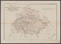
- Part of the railway belt, British Columbia
- Description:
- Accompanies: Annual report of the Topographical Surveys Branch, 1908-1909., Relief shown by hachures and spot heights., and Shows primary and secondary triangulations.
- Publisher:
- Topographical Surveys Branch,
- Subject (Geographic):
- British Columbia--Maps
- Subject (Topic):
- Triangulation--British Columbia--Maps
- Found in:
- Beinecke Rare Book and Manuscript Library > Sketch map of part of the railway belt, British Columbia : showing main topographical features in the districts drained by the Blaeberry River, Bush River, Gold Creek and their confluents. Also the Continental Divide northwest from Mt. Freshfield.