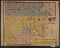
1. Map of Oklahoma and Cherokee Strip / compiled from the official records of the General Land Office Creator: Hudson-Kimberly Pub. Co Published / Created: [189-?] Call Number: 827fb 1890 Container / Volume: BRBL_00578 Image Count: 1 Resource Type: Maps, Atlases & Globes Description: Includes list of "Location of county seats in Cherokee Strip," township diagram, location map, and inset of Beaver Co. (scale [1:887,040].) Publisher: Hudson-Kimberly Publishing, Subject (Geographic): Cherokee Strip (Okla. and Kan.)--Maps and Oklahoma--Maps Found in: Beinecke Rare Book and Manuscript Library > Map of Oklahoma and Cherokee Strip / compiled from the official records of the General Land Office, and other authentic sources, by Hudson-Kimberly Publishing Co.