Skip to search
Skip to main content
Skip to first result
Search
You Searched For
Extent of Digitization
Completely digitized
Language
Latin
Publication Place
[Amsterdam] :
Search Results
Creator:
Published / Created:
[1688?]
Call Number:
BrSides Double Folio 2018 10
Image Count:
1
Resource Type:
Maps, Atlases & Globes
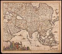
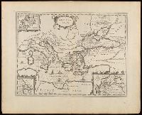
Description:
Appears in various editions of Wit's Atlas.
Publisher:
[Frederik de Wit],
Subject (Geographic):
Asia--Maps--Early works to 1800.
Subject (Name):
Wit, Frederik de. Atlas.
Found in:
Beinecke Rare Book and Manuscript Library > Accuratissima totius Asiae tabula [cartographic material] : in omnes partes divisa, de nova correcta, ac in lucem edita / per Fredericum de Witt Amstelodami cum privilegio D.D. ordinum Hollandiae Westristacq[ue] ; F. de Wit excudit.
Creator:
Published / Created:
[approximately 1700?]
Call Number:
BrSides Double Folio 2019 68
Image Count:
1
Resource Type:
Maps, Atlases & Globes
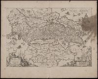
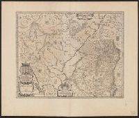
Alternative Title:
Achaiae noua & accurata descriptio and Achaiae nova et accurata descriptio
Description:
Coordinates not present on map and are approximated.
Publisher:
[Jan Jansson],
Subject (Geographic):
Achaia (Greece)--Maps--Early works to 1800.
Subject (Name):
Jansson, Jan, 1588-1664
Found in:
Beinecke Rare Book and Manuscript Library > Achaiae nova & accurata descriptio / autore I. Laurenbergio.
Creator:
Published / Created:
[170-?]
Call Number:
70 170X
Container / Volume:
BRBL_00686
Image Count:
1
Resource Type:
Maps, Atlases & Globes
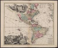
Description:
Includes ill., text, and table of latitudes and longitudes.
Publisher:
Ex officina Petri Schenkii ...,
Subject (Geographic):
America--Maps--Early works to 1800
Subject (Name):
Schenk, Peter, 1660-1718 or 1719
Found in:
Beinecke Rare Book and Manuscript Library > Americae tam septentrionalis quam meridionalis in mappa geographica delineatio ... / opera A.F. Zürneri ...
Creator:
Published / Created:
[approximately 1700]
Call Number:
BrSides Double Folio 2019 63
Image Count:
1
Resource Type:
Maps, Atlases & Globes
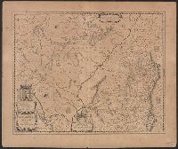
Alternative Title:
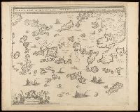
Archipelagi meridionalis, seu Cycladvm Insularum accurata delineatio
Description:
Includes three bar scales.
Publisher:
[Jan Jansson],
Subject (Geographic):
Aegean Islands (Greece and Turkey)--Maps--Early works to 1800., Cyclades (Greece)--Maps--Early works to 1800., Dodecanese Islands (Greece)--Maps--Early works to 1800., and Sporades (Greece)--Maps--Early works to 1800.
Subject (Name):
Jansson, Jan, 1588-1664
Found in:
Beinecke Rare Book and Manuscript Library > Archipelagi meridionalis, seu Cycladum Insularum accurata delineatio / autore I. Laurenbergio.
Creator:
Published / Created:
[between 1652 and 1684]
Call Number:
BrSides Double Folio 2019 56
Image Count:
1
Resource Type:
Maps, Atlases & Globes
Alternative Title:
Argonautica
Description:
Appeared in various editions of Jan Jansson's Accuratissima orbis antiqui delineatio.
Publisher:
[Jan Jansson],
Subject (Geographic):
Mediterranean Region--Maps--Early works to 1800.
Subject (Name):
Jansson, Jan, 1588-1664. Accuratissima orbis antiqui delineatio.
Subject (Topic):
Argonauts (Greek mythology)--Travel--Maps--Early works to 1800. and Literary landmarks--Mediterranean Region--Maps--Early works to 1800.
Found in:
Beinecke Rare Book and Manuscript Library > Argonavtica / Petrus Kaerius caelavit aetatis suae 74.
Creator:
Published / Created:
[1662?]
Call Number:
3945 1662
Container / Volume:
BRBL_00193
Image Count:
2
Resource Type:
Maps, Atlases & Globes
Alternative Title:
Arragonia regnvm
Description:
Latin on recto, verso.
Publisher:
Guilj. et Iohannes Blaeu,
Subject (Geographic):
Aragon (Spain)--Maps--Early works to 1800
Found in:
Beinecke Rare Book and Manuscript Library > Arragonia regnum / auctore Joanne Baptista Labanna.
Creator:
Published / Created:
[1640?]
Call Number:
3945 1640
Container / Volume:
BRBL_00193
Image Count:
2
Resource Type:
Maps, Atlases & Globes
Alternative Title:
Arragonia regnvm
Description:
Latin on recto, verso.
Publisher:
Guilj. et Iohannes Blaeu,
Subject (Geographic):
Aragon (Spain)--Maps--Early works to 1800
Found in:
Beinecke Rare Book and Manuscript Library > Arragonia regnum / auctore Joanne Baptista Labanna.
Published / Created:
[between 1652 and 1684]
Call Number:
BrSides Double Folio 2019 99
Image Count:
1
Resource Type:
Maps, Atlases & Globes
Abstract:
Map of Great Britain, and part of Ireland.
Alternative Title:
Britannia prout divisa fuit temporibus Anglo-Saxonum praesertim durante illorum heptarchia.
Description:
Border illustrations include seven Anglo-Saxon kings on the left; the conversion to Christianity of a further seven are depicted on the right.
Publisher:
[Jan Jansson],
Subject (Geographic):
Great Britain--Maps--Early works to 1800.
Found in:
Beinecke Rare Book and Manuscript Library > Britannia prout divisa fuit temporibus Anglo-Saxonvm praesertim durante illorum heptarchia.
Creator:
Published / Created:
[1638]
Call Number:
90 1638
Container / Volume:
BRBL_00661
Image Count:
1
Resource Type:
Maps, Atlases & Globes
Description:
From Jan Huygen van Linschoten's Histoire de la navigation de Iean Hvgves de Linschot Hollandois.
Publisher:
[Evert Cloppenburgh],
Subject (Geographic):
South America--Maps--Early works to 1800
Subject (Name):
Linschoten, Jan Huygen van, 1563-1611. Histoire de la navigation de Iean Hvgves de Linschot Hollandois
Found in:
Beinecke Rare Book and Manuscript Library > Delineatio omnium orarum totius Australis partis Americae ... / Arnoldus Florentius à Langren, author & sculptor.
Creator:
Published / Created:
[1607]
Call Number:
11 1607
Container / Volume:
BRBL_00003
Image Count:
2
Resource Type:
Maps, Atlases & Globes
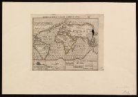
Description:
Imperfect: two small holes at upper right corner where oxidized by pigment. Label on verso with manuscript number "550/149." Cross collection no. 6. Mounted on paper.
Publisher:
[Jodocus Hondius],
Subject (Topic):
World maps--Early works to 1800.
Found in:
Beinecke Rare Book and Manuscript Library > Designatio orbis Christiani.
Branch:v1.70.9 ,Deployed:2025-10-15T09:50:38-04:00