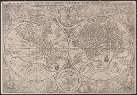
Orbis terrarvm typvs de integro multis in locis emendatus
Description:
Copy 1: Imperfect: chipped along folds, with some loss of text. Backed with linen. and Double hemispherical map of the world, with 2 smaller celestial hemispheres. New Guinea shown as part of southern continent called Magallanica. The two hemispheres are surr
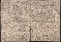
Orbis terrarvm typvs de integro multis in locis emendatus
Description:
Copy 2: Imperfect: chipped along folds, with some loss of text. Backed with paper. and Double hemispherical map of the world, with 2 smaller celestial hemispheres. New Guinea shown as part of southern continent called Magallanica. The two hemispheres are surr
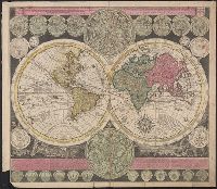
Vlakke aard-kloot met het beide hemelsch half-rond, of de onder scheidene verbeelding van de land-water-waereld
Description:
"De Warmoes Straat sub signo R. Visschers Athlas"., Cross collection no. 29., Double hemispherical world map showing routes of explorers including Magellan, Dampier, Tasman and Chaumont., Includes twenty-six smaller astronomical diagrams and hemispheres of the world, two larger celestial hemispheres and textual commentary., and Relief shown pictorially.
Publisher:
Ex officina Petri Schenkii ...,
Subject (Geographic):
Australia--Maps--Early works to 1800
Subject (Name):
Schenk, Peter, 1660-1718 or 1719. Atlas contractus