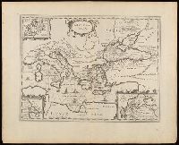
Appeared in various editions of Jan Jansson's Accuratissima orbis antiqui delineatio., Includes three insets: Europa; Minoium pelagus; Propontis [Sea of Marmora]., Manuscript number in upper left corner: 24., Relief shown pictorially., and Verso blank.
Publisher:
[Jan Jansson],
Subject (Geographic):
Mediterranean Region--Maps--Early works to 1800.
Subject (Name):
Jansson, Jan, 1588-1664. Accuratissima orbis antiqui delineatio.
Subject (Topic):
Argonauts (Greek mythology)--Travel--Maps--Early works to 1800. and Literary landmarks--Mediterranean Region--Maps--Early works to 1800.
Britannia prout divisa fuit temporibus Anglo-Saxonum praesertim durante illorum heptarchia.
Description:
Border illustrations include seven Anglo-Saxon kings on the left; the conversion to Christianity of a further seven are depicted on the right., Manuscript number in upper left corner: 7., Relief shown pictorially., and Shows kingdom boundaries, rivers, settlements and shields.
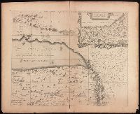
Dimidia Tribvs Manasse ultra Jordanem, tribus Neptalim et partes orientales Tribuum Zabvion et Isachar
Description:
Appears in Jansson's historical atlas editions from 1652-1684 and in his Accuratissima orbis antiqui delineatio. From 1653 on, this work is known under the name of Hornius, who wrote the text and compiled all the maps for the atlases--(Koeman-Krogt. 1:601-1:607)., Coordinates not present on map and are approximated., Inset: Peregrinatio Abrahae., Map indexed with grid lines and alphabet letters P-R at top., Oriented with north toward the left., Printed on one and a half sheets., Relief shown pictorially., and Watermark. Manuscript numbers in upper left and right corners: 46. No. 4 of 6 maps housed together.
Publisher:
[Jan Jansson],
Subject (Geographic):
Palestine--History--To 70 A.D.--Maps--Early works to 1800. and Palestine--Maps--Early works to 1800.
Keere, Pieter van den, 1571-approximately 1646, cartographer.
Published / Created:
[between 1652 and 1684]
Call Number:
BrSides Double Folio 2019 103
Image Count:
1
Resource Type:
Maps, Atlases & Globes
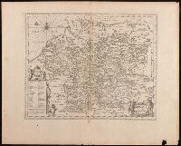
Description:
Appears in Jansson's historical atlas editions from 1652-1684., Manuscript number in upper left corner: 13., and Relief shown pictorially.
Publisher:
Apud Joannem Janssonium,
Subject (Geographic):
Benelux countries--Historical geography--Maps--Early works to 1800., Benelux countries--Maps--Early works to 1800., Europe, Central--Historical geography--Maps--Early works to 1800., and Europe, Central--Maps--Early works to 1
Subject (Name):
Jansson, Jan, 1588-1664, publisher.
Subject (Topic):
Ethnology--Europe--Maps--Early works to 1800. and Germanic peoples--Maps--Early works to 1800.
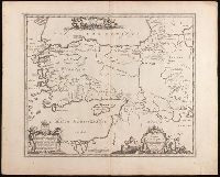
Appeared in various editions of Jan Jansson's Accuratissima orbis antiqui delineatio., Includes four bar scales., Relief shown pictorially., Verso blank., and Watermark. Manuscript number in upper left corner: 25.
Publisher:
[Jan Jansson],
Subject (Geographic):
Greece--Maps--Early works to 1800.
Subject (Name):
Jansson, Jan, 1588-1664. Accuratissima orbis antiqui delineatio.
Appeared in various editions of Jan Jansson's Accuratissima orbis antiqui delineatio., Coordinates not accurate as presented on map and are approximated., Relief shown pictorially., and Watermark. Manuscript number in upper left corner: 15.
Publisher:
[Jan Jansson],
Subject (Geographic):
Cisalpine Republic--Maps--Early works to 1800. and Lombardy (Italy)--Maps--Early works to 1800.
Subject (Name):
Jansson, Jan, 1588-1664. Accuratissima orbis antiqui delineatio. and Ortelius, Abraham, 1527-1598
Subject (Topic):
Historical geography--Italy--Lombardy--Maps--Early works to 1800.
Nova & accurata Tusciae antiquae descriptio, Nova et accurata Tusciae antiquae descriptio, and Nova et accurata Tvsciae antiqvae descriptio
Description:
Appeared in various editions of Jan Jansson's Accuratissima orbis antiqui delineatio., Borders are hand colored., Coordinates not accurate as presented on map and are approximated., Manuscript number in upper left corner: 16., Relief shown pictorially., and Verso blank.
Publisher:
[Jan Jansson],
Subject (Geographic):
Tuscany (Italy)--Maps--Early works to 1800.
Subject (Name):
Jansson, Jan, 1588-1664. Accuratissima orbis antiqui delineatio. and Ortelius, Abraham, 1527-1598
Subject (Topic):
Historical geography--Italy--Tuscany--Maps--Early works to 1800.
Appears in Jansson's historical atlas editions from 1652-1684 and in his Accuratissima orbis antiqui delineatio. From 1653 on, this work is known under the name of Hornius, who wrote the text and compiled all the maps for the atlases--(Koeman-Krogt. 1:601-1:607)., Coordinates not present on map and are approximated., Inset: Itinera et mansiones deserti., Map indexed with grid lines and alphabet letters A-H at top., Oriented with north toward the left., Relief shown pictorially., Shows greater part of the Tribe of Judah, with Biblical illustrations., and Watermark. Manuscript number in upper left corner: 48. No. 5 of 6 maps housed together.
Publisher:
[Jan Jansson],
Subject (Geographic):
Palestine--History--To 70 A.D.--Maps--Early works to 1800. and Palestine--Maps--Early works to 1800.
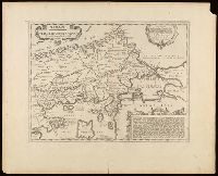
Appeared in various editions of Jan Jansson's Accuratissima orbis antiqui delineatio., Descriptive text in lower right cartouche beginning "Thraciae aliquot incogniti situs loca ...", Manuscript number in upper left corner: 22., Relief shown pictorially., Title in Greek and Latin; text in Latin., and Verso blank.
Publisher:
[Jan Jansson],
Subject (Geographic):
Bulgaria--Maps--Early works to 1800., Thrace--Maps--Early works to 1800., and Turkey--Maps--Early works to 1800.
Subject (Name):
Jansson, Jan, 1588-1664. Accuratissima orbis antiqui delineatio. and Ortelius, Abraham, 1527-1598