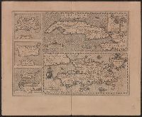
Cuba Insula includes inset "Havana portus celeberimus totius indiae Occidentalis.", French text on verso; with caption title "Les isles de la Cuba, Espaignole, Iamaique, de S. Iean et Margarite," paginated 701, 704, with signatures 8P., and Relief shown pictorially.
Publisher:
Hendrik Hondius,
Subject (Geographic):
Cuba--Maps--Early works to 1800 and Hispaniola--Maps--Early works to 1800
Subject (Name):
Hondius, Hendrik, 1597-1651 and Mercator, Gerhard, 1512-1594. Atlas. French
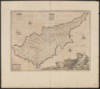
Bar scales given in "milliaria Italica" and "milliaria Germanica"., From Joan Blaeu's Atlas maior. Amstelaedami : ... Ioannis Blaeu, 1662., In Latin on verso; running title "Cyprus Insula," paginated 25-26, with signature I., Prime meridian: Ferro., and Relief sh
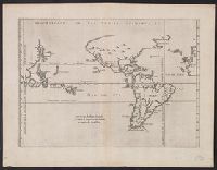
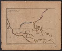
From Herrera y Tordesillas's Descripción de las Indias Occidentales ... Amstelodami : Apud M. Colinium, 1622., Map of the World from China, west to Spain showing the 'Merida, Relief shown pictorially., and Sheet measures 28.5 x 36.9 cm. Cross Collection no. 112.
Publisher:
Michiel Colijn,
Subject (Geographic):
World maps--Early works to 1800
Subject (Name):
Colijn, Michiel, Herrera y Tordesillas, Antonio de, d. 1625. Descripción de las Indias Occidentales. Latin, and Portugal.--Treaties, etc.--Spain--(1494 June 7)
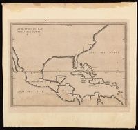
Appears in French eds. of Herrera y Tordesilla's Descripción de las Indias Occidentales published in Amsterdam., Sheet measures 28.7 x 35.2 cm. Cross Collection no. 227., and Shows coasts of the southern part of North America, Central America, northern coast of South America, and West Indies.
Publisher:
Michiel Colijn,
Subject (Geographic):
America--Maps--Early works to 1800., Central America--Maps--Early works to 1800., and West Indies--Maps--Early works to 1800.
Subject (Name):
Colijn, Michiel, publisher. and Herrera y Tordesillas, Antonio de, -1625. Descripción de las Indias Occidentales. French.
Appears in French eds. of Herrera y Tordesilla's Descripción de las Indias Occidentales published in Amsterdam., Sheet measures 28.7 x 35.2 cm. Cross Collection no. 227., and Shows coasts of the southern part of North America, Central America, northern coast of South America, and West Indies.
Publisher:
s.n. ,
Subject (Name):
Herrera y Tordesillas, Antonio de, d. 1625. Descripción de las Indias Occidentales. French
Subject (Topic):
Coasts--Central America--Maps--Early works to 1800, Coasts--North America--Maps--Early works to 1800, Coasts--South America--Maps--Early works to 1800, and Coasts--West Indies--Maps--Early works to 1800
Description, situation and vue de la ville de Mexique
Description:
"Tom: VI. No. 28. Pag: 110.", Caption title., Carte du Mexique -- Environs du Lac de Mexique., From Chatelain's Atlas historique ... [v. 6, no. 28, p. 110] Amsterdam : Chez L'Honoré & Châtelain, 1718-21., and Includes ill. and text, "La Province de Mexique ... & plus de 100, mille Esclaves."
Publisher:
L'Honoré & Châtelain,
Subject (Geographic):
Mexico City (Mexico)--Maps--Early works to 1800 and Mexico--Maps--Early works to 1800
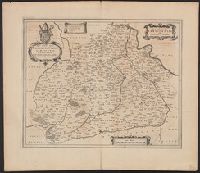
Bar scale given in "miglia sette.", Relief shown pictorially., and Sheet printed from cracked plate. Backed with paper. Ms. no. "72" in upper right corner. Sheet measures 53.7 x 62.6 cm. No. 67 of 87 maps bound together.
Publisher:
Joan Blaeu,
Subject (Geographic):
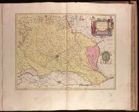
Parma (Italy : Province)--Maps--Early works to 1800. and Piacenza (Italy : Province)--Maps--Early works to 1800.
Bar scale given in "miglia sette.", Decorative cartouche., In Latin on verso, with running title "Ducatus Parma et Placentia," paginated 29, with signature 2A., Relief shown pictorially., and Stamp on verso: Karpinski-von Wieser Map Collection.
Publisher:
Blaeu,
Subject (Geographic):
Parma (Italy : Province)--Maps--Early works to 1800 and Piacenza (Italy : Province)--Maps--Early works to 1800
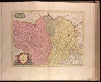
Backed with paper. Ms. no. "73" in upper right corner. Sheet measures 53.6 x 63.0 cm. No. 68 of 87 maps bound together., Bar scale given in "miglia sette d'Italia.", and Relief shown pictorially.
Publisher:
Joan Blaeu,
Subject (Geographic):
Milan (Italy : Province)--Maps--Early works to 1800.