Skip to search
Skip to main content
Skip to first result
Search
You Searched For
Language
German
Publication Place
[Berlin] :
Subject (Geographic)
France--Maps
New Search
Search Results
Creator:
Published / Created:
1940
Call Number:
11hd 1942D-54
Container / Volume:
BRBL_00010ZE
Image Count:
1
Resource Type:
Maps, Atlases & Globes
Alternative Title:
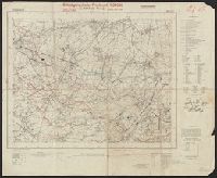
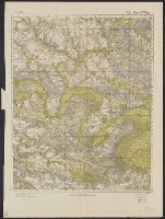
Frankreich and St. Amand
Description:
"Stand 29.3.1940, teilweise 7.4.1940." and Includes legend, list of abbreviations, chart of connecting sheets, and map showing political boundaires.
Publisher:
German General Staff,
Subject (Geographic):
France--Maps
Found in:
Beinecke Rare Book and Manuscript Library > Befestigungskarte Frankreich 1:25000 : St. Amand, Nr. 1-2, XXVI-5/1-2.
Creator:
Published / Created:
1940
Call Number:
11hd 1942D-54
Container / Volume:
BRBL_00010ZE
Image Count:
1
Resource Type:
Maps, Atlases & Globes
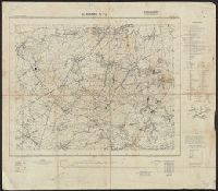
Alternative Title:
Frankreich and St. Amand
Description:
"Stand 29.3.1940, teilweise 7.4.1940." and Includes legend, list of abbreviations, chart of connecting sheets, and map showing political boundaires.
Publisher:
German General Staff,
Subject (Geographic):
France--Maps
Found in:
Beinecke Rare Book and Manuscript Library > Befestigungskarte Frankreich 1:25000 : St. Amand, Nr. 1-2, XXVI-5/1-2.
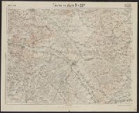
Published / Created:
1918
Call Number:
11hc 1918-Z18
Container / Volume:
BRBL_00010G
Image Count:
1
Resource Type:
Maps, Atlases & Globes
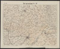
Description:
"Die braunen Schichtlinien umgrenzen Stufen von 10 meter Höhen-Abstand.", "Febr.1918." above upper left margin., "Kartographische Abteilung d. Kgl. Preuβ. Landesaufnahme.", German and French., Includes index of connecting sheets., and Shows area surrounding St. Q
Publisher:
s.n.,
Subject (Geographic):
France--Maps
Found in:
Beinecke Rare Book and Manuscript Library > Einheitsblatt Nr.14F.
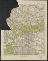
Published / Created:
1918
Call Number:
11hc 1918-Z19
Container / Volume:
BRBL_00010G
Image Count:
1
Resource Type:
Maps, Atlases & Globes
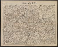
Description:
"Die braunen Schichtlinien umgrenzen Stufen von 10 meter Höhen-Abstand.", "Febr.1918." above upper left margin., "Kartographische Abteilung d. Kgl. Preuβ. Landesaufnahme.", German, Includes index of connecting sheets., and Shows area surrounding Soissons, France.
Publisher:
s.n.,
Subject (Geographic):
France--Maps
Found in:
Beinecke Rare Book and Manuscript Library > Einheitsblatt Nr.18F.
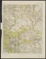
Published / Created:
1918
Call Number:
11hc 1918-Z17
Container / Volume:
BRBL_00010G
Image Count:
1
Resource Type:
Maps, Atlases & Globes
Description:
"April.1918." above upper left margin., "Die braunen Schichtlinien umgrenzen Stufen von 10 meter Höhen-Abstand.", "Kartographische Abteilung d. Kgl. Preuβ. Landesaufnahme.", German and French., Includes index of connecting sheets., and Shows area surrounding Chal
Publisher:
s.n.,
Subject (Geographic):
France--Maps
Found in:
Beinecke Rare Book and Manuscript Library > Einheitsblatt Nr.22F.
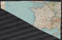
Creator:
Published / Created:
1942-1944.
Call Number:
38cbf 1943
Container / Volume:
BRBL_00168
Image Count:
1
Resource Type:
Maps, Atlases & Globes
Alternative Title:
Deutsche Heerskarte and Frankreich 1:200,000 Zus.-Druck
Description:
[2] Les Pieux-Caen -- [3] Abbeville-Paris -- [5] Lannion-Lorient -- [6] Rennes-Angers -- [7] Chartres-Orléans -- [8] Troyes-Vesoul -- [9] Nantes-La Rochelle -- [10] Châteauroux-Moulins -- [13] Limoges-Aurillac -- [15] Vieux-Boucau-Luz. and Each sheet covers
Publisher:
Gen. St. de H. Abt. f Kr. Kart. u Verm. Wes.,
Subject (Geographic):
France--Maps
Found in:
Beinecke Rare Book and Manuscript Library > Frankreich 1:200,000 Zusammendruck [cartographic material].
Published / Created:
1916
Call Number:
11hc 1918-Z6
Image Count:
1
Resource Type:
Maps, Atlases & Globes
Alternative Title:
Rethel
Description:
"Nachdruck ohne diese Angabe untersagt.", "Photoalgraphie d.Kartog. Abt.d.Stello. Generalstabes d.Armee 1916.", and German and French.
Publisher:
s.n.,
Subject (Geographic):
France--Maps
Found in:
Beinecke Rare Book and Manuscript Library > [23. Rethel. Bl.8.]
Published / Created:
1918
Call Number:
11hc 1918-Z8
Image Count:
1
Resource Type:
Maps, Atlases & Globes
Alternative Title:
Beauvais-Ost
Description:
"Februar 1918.", Imperfect. Mutilated., and Includes index of connecting sheets
Publisher:
s.n.,
Subject (Geographic):
France--Maps
Found in:
Beinecke Rare Book and Manuscript Library > [32. Beauvais-Ost.]
Published / Created:
1918
Call Number:
11hc 1918-Z10
Container / Volume:
BRBL_00010G
Image Count:
1
Resource Type:
Maps, Atlases & Globes
Alternative Title:
Paris-Ost
Description:
"Februar 1918." and Includes index of connecting sheets
Publisher:
s.n.,
Subject (Geographic):
France--Maps
Found in:
Beinecke Rare Book and Manuscript Library > [48. Paris-Ost.]
Published / Created:
1918
Call Number:
11hc 1918-Z9
Image Count:
1
Resource Type:
Maps, Atlases & Globes
Alternative Title:
Paris-West
Description:
"Februar 1918." and Includes index of connecting sheets
Publisher:
s.n.,
Subject (Geographic):
France--Maps
Found in:
Beinecke Rare Book and Manuscript Library > [48. Paris-West.]
Branch:v1.61.6 ,Deployed:2024-06-12T09:55:36-04:00