Skip to search
Skip to main content
Skip to first result
Search
You Searched For
Extent of Digitization
Completely digitized
Publication Place
[Chicago] :
Search Results
Creator:
Published / Created:
1907
Call Number:
777 B21 1907
Container / Volume:
BRBL_00503
Image Count:
1
Resource Type:
Maps, Atlases & Globes
Alternative Title:
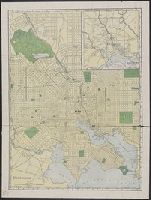
Map of Baltimore and environs
Description:
Identifies street names, major buildings, and street car lines.
Publisher:
Rand McNally & Co.,
Subject (Geographic):
Baltimore (Md.)--Maps
Found in:
Beinecke Rare Book and Manuscript Library > Baltimore.
Creator:
Published / Created:
c1911.
Call Number:
792 1911C
Container / Volume:
BRBL_00519
Image Count:
1
Resource Type:
Maps, Atlases & Globes
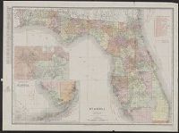
Alternative Title:
Rand, McNally & Co.'s New business atlas map of Florida
Description:
Includes table for identifying marked Florida railroads.
Publisher:
Rand, McNally & Co.,
Subject (Geographic):
Florida--Maps
Subject (Topic):
Railroads--Florida--Maps
Found in:
Beinecke Rare Book and Manuscript Library > Florida.
Published / Created:
[1880?].
Call Number:
75gme 1880M
Container / Volume:
BRBL_00413
Image Count:
1
Resource Type:
Maps, Atlases & Globes
Description:
Insets: Vicinity of Boston ; Vicinity of New York and Philadelphia.
Publisher:
Rand McNally & Co.,
Subject (Geographic):
United States--Maps
Found in:
Beinecke Rare Book and Manuscript Library > General railroad map of the United States and Canada, showing the Macon & Brunswick Railroad and its connections.
Creator:
Published / Created:
[1960]
Call Number:
832 1960
Container / Volume:
BRBL_00582
Image Count:
2
Resource Type:
Maps, Atlases & Globes
Alternative Title:
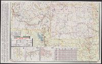
Sinclair, Idaho, Montana, Wyoming
Description:
"0-5648-6."
Publisher:
Rand McNally,
Subject (Geographic):
Idaho--Maps, Montana--Maps, and Wyoming--Maps
Subject (Name):
Sinclair Oil Corporation
Subject (Topic):
Roads--Idaho--Maps, Roads--Montana--Maps, and Roads--Wyoming--Maps
Found in:
Beinecke Rare Book and Manuscript Library > Idaho, Montana, Wyoming / [prepared for] Sinclair.
Creator:
Published / Created:
c1911.
Call Number:
761gme 1911
Container / Volume:
BRBL_00449
Image Count:
1
Resource Type:
Maps, Atlases & Globes
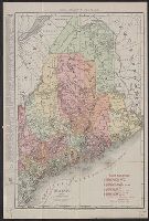
Alternative Title:
Rand McNally & Co.'s new business atlas map of Maine. and Rand-McNally indexed atlas.
Description:
Includes key to railroads.
Publisher:
Rand, McNally & Co.,
Subject (Geographic):
Maine--Maps
Subject (Topic):
Electric lines--Maine--Maps, Railroads--Maine--Maps, and Steamboat lines--Maine--Maps
Found in:
Beinecke Rare Book and Manuscript Library > Maine / Rand McNally & Co.
Creator:
Published / Created:
1911
Call Number:
814 1911
Container / Volume:
BRBL_00557
Image Count:
1
Resource Type:
Maps, Atlases & Globes
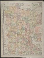
Abstract:
Shows railroads and counties.
Description:
Includes indexes and insets of "N.E. corner of Minnesota, showing Cook County" and "Minneapolis, St. Paul and vicinity."
Publisher:
Rand, McNally & Co.,
Subject (Geographic):
Minnesota--Maps
Subject (Topic):
Railroads--Minnesota--Maps
Found in:
Beinecke Rare Book and Manuscript Library > Minnesota.
Creator:
Published / Created:
1909
Call Number:
733gme 1909A
Container / Volume:
BRBL_00379
Image Count:
1
Resource Type:
Maps, Atlases & Globes
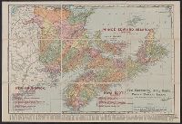
Alternative Title:
Rand, McNally & Co.'s New Brunswick, Nova Scotia, and Prince Edward Island and Rand, McNally & Co.'s New Business Atlas Map of the Maritime Provinces of Canada
Description:
"Copyright 1909, by Rand, McNally & Co. Copyright 1892, by Rand, McNally & Co."
Publisher:
Rand, McNally & Co.,
Subject (Geographic):
New Brunswick--Maps, Nova Scotia--Maps, and Prince Edward Island--Maps
Subject (Topic):
Counties--New Brunswick--Maps, Counties--Nova Scotia--Maps, Lighthouses--New Brunswick--Maps, Lighthouses--Nova Scotia--Maps, Lighthouses--Prince Edward Island--Maps, and Railroads--New Brunswick--Maps
Found in:
Beinecke Rare Book and Manuscript Library > New Brunswick, Nova Scotia, and Prince Edward Island : The Maritime Provinces of Canada.
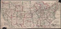
Creator:
Published / Created:
1879
Call Number:
75gme 1879
Container / Volume:
BRBL_00413
Image Count:
2
Resource Type:
Maps, Atlases & Globes
Publisher:
E. Heubach,
Subject (Geographic):
United States--Maps
Found in:
Beinecke Rare Book and Manuscript Library > New railroad map of the United States and the Dominion of Canada, showing the Chicago, Rock Island and Pacific R.'y, the Great Overland route, and short line to the West and Southwest / by Emil Heubach, Designer and Engraver.
Creator:
Published / Created:
c1895.
Call Number:
785 1895
Container / Volume:
BRBL_00513
Image Count:
2
Resource Type:
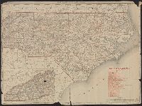
Maps, Atlases & Globes
Alternative Title:
Rand, McNally & Co.'s New 11 x 14 map of North Carolina
Description:
Inset: Western portion of North Carolina).
Publisher:
Rand McNally & Co.,
Subject (Geographic):
North Carolina--Maps
Found in:
Beinecke Rare Book and Manuscript Library > North Carolina.
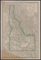
Creator:
Published / Created:
[188-?]
Call Number:
832 1881
Container / Volume:
BRBL_00582
Image Count:
1
Resource Type:
Maps, Atlases & Globes
Alternative Title:
Idaho
Description:
Relief shown by hachures.
Publisher:
Rand McNally,
Subject (Geographic):
Idaho--Maps
Found in:
Beinecke Rare Book and Manuscript Library > Rand McNally & Co.'s Idaho.
Branch:v1.68.6 ,Deployed:2025-07-02T08:09:34-04:00