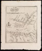
Chart of the mouth of the Sierra Leone River showing shallows and soundings.
Description:
"No. 6" in upper right corner; "IV.D." in lower right corner., Coordinates not present on map and are approximated., Depths shown by soundings., and From Almindelig histoirie over reiser til lands og bands ... (Kjøbenhavn: Niels Hansen Møller, 1749), a translation of Collection of voyages and travels edited by Awnsham Chruchill and Thomas Osborne.
Publisher:
[Niels Hansen Møller],
Subject (Geographic):
Sierra Leone River--Maps--Early works to 1800.
Subject (Name):
Churchill, Awnsham, -1728. Collection of voyages and travels. Danish., Møller, Niels Hansen, and Osborne, Thomas, -1767. Collection of voyages and travels. Danish.
Subject (Topic):
Coasts--Sierra Leone--Maps--Early works to 1800. and Navigation--Sierra Leone River--Early works to 1800.