Skip to search
Skip to main content
Skip to first result
Search
You Searched For
Format
cartographic
Publication Place
[London?] :
New Search
Search Results
Creator:
Published / Created:
1905
Call Number:
658 1905
Container / Volume:
BRBL_00346
Image Count:
1
Resource Type:
Maps, Atlases & Globes
Alternative Title:
Liberia, T.S.G.S. (Series) ; no. 2083., and T.S.G.S. ; no. 2083.
Description:
"Parts of sheets 59 & 71." and Relief shown by form lines and spot heights.
Publisher:
Topographical Section, General Staff,
Subject (Geographic):
Liberia--Maps
Found in:
Beinecke Rare Book and Manuscript Library > Africa 1:1,000,000. Liberia.
Published / Created:
1855
Call Number:
26cea 1843B
Container / Volume:
BRBL_00023
Image Count:
1
Resource Type:
Maps, Atlases & Globes
Description:
Preliminary record.
Publisher:
Published according to Act of Parliament at the Hydrographic Office of the Admiralty,
Subject (Geographic):
Australia--Maps
Found in:
Beinecke Rare Book and Manuscript Library > Australia, East Coast Sheet XIX. Cape Flattery to Cape Sidmouth and the Barrier Reefs, surveyed by Capt. F. Blackwood, C.B. Yule, Mr. F.I. Evans; Master, Mr. D. Aird, Mate H.M.S. Fly, and Capt. Owen Stanley, Lieuts. C.B. Yule, J. Dayman, H.G. Simpson and
Creator:
Published / Created:
1911
Call Number:
652 Ar86 1911A
Container / Volume:
BRBL_00343
Image Count:
1
Resource Type:
Maps, Atlases & Globes
Alternative Title:
Chart of the River Aruwimi and The River Aruwimi [cartographic material]
Description:
"The Geographical Journal, 1911".
Publisher:
The Society,
Subject (Geographic):
Congo (Democratic Republic)--Maps
Found in:
Beinecke Rare Book and Manuscript Library > Belgian Congo. Chart of the River Aruwimi : from a survey by Robt. L. Reid, 1908-10.
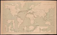
Creator:
Published / Created:
1909
Call Number:
BrSides Double Folio 2018 95
Image Count:
1
Resource Type:
Maps, Atlases & Globes
Alternative Title:
G.S.G.S. ; No. 1849 and GSGS (Series) ; No. 1849
Description:
Backed with linen. and Includes grid, notes and 6 inset maps.
Publisher:
War Office,
Subject (Topic):
Cables, Submarine--Maps., Telegraph, Telegraph--Maps., and World maps
Found in:
Beinecke Rare Book and Manuscript Library > Cable map of the world [cartographic material].
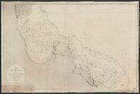
Published / Created:
1814
Call Number:
26cea 1799
Container / Volume:
BRBL_00023
Image Count:
1
Resource Type:
Maps, Atlases & Globes
Description:
Inset: Curtis Id. and Preliminary record.
Publisher:
Published as the Act directs by Capt. Hurd. R.N. Hydrographer to the Admiralty,
Subject (Geographic):
Australia--Maps--Early works to 1800
Found in:
Beinecke Rare Book and Manuscript Library > Chart of Terra Australis by M. Flinders, Commr. of H.M. Sloop Investigator 1799-1803. East Coast sheet III ...
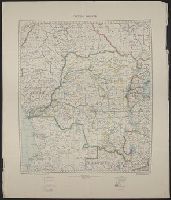
Creator:
Published / Created:
1921
Call Number:
652 1921
Container / Volume:
BRBL_00342
Image Count:
1
Resource Type:
Maps, Atlases & Globes
Description:
Information on map as of 1918., Relief shown by gradient tints., and Sheet measures 74 x 65 cm.
Publisher:
Geographical Section, General Staff,
Subject (Geographic):
Congo (Democratic Republic)--Maps
Found in:
Beinecke Rare Book and Manuscript Library > Congo Belge.
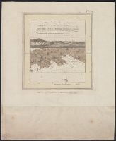
Creator:
Published / Created:
May 1st 1781.
Call Number:
732cea Q31 1781
Container / Volume:
BRBL_00378
Image Count:
1
Resource Type:
Maps, Atlases & Globes
Description:
From the author's Atlantic Neptune., In upper right margin: Pl. 29., Includes text and view of coast., Oriented with north to bottom., and Relief shown by hachures. Depths shown by soundings.
Publisher:
J.F.W. Des Barres,
Subject (Geographic):
Chedabucto Bay (N.S.)--Maps--Early works to 1800
Subject (Name):
Des Barres, Joseph F. W. (Joseph Frederick Wallet), 1722-1824. Atlantic neptune
Subject (Topic):
Coasts--Nova Scotia--Maps--Early works to 1800, Harbors--Nova Scotia--Maps--Early works to 1800, and Nautical charts--Nova Scotia--Early works to 1800
Found in:
Beinecke Rare Book and Manuscript Library > Crow Harbor, on the south shore of Chedabuctou Bay.
Published / Created:
1931
Call Number:
11hc 1918E
Container / Volume:
BRBL_00010E
Image Count:
2
Resource Type:
Maps, Atlases & Globes
Description:
Laminated page and articles from the Daily Express, Friday June 19, 1931.
Publisher:
Daily Express,
Subject (Geographic):
Belgium--Maps and France--Maps
Found in:
Beinecke Rare Book and Manuscript Library > Earl Haig's war map refutes General Pershing.
Creator:
Published / Created:
1954
Call Number:
63 1954 Sheet 1
Container / Volume:
BRBL_00335
Image Count:
1
Resource Type:
Maps, Atlases & Globes
Alternative Title:
D.C.S. (Misc.) ; 203a and D.C.S. (Series) ; 203a.
Description:
"8,500/10/54 S.P.C., R.E.", "Map 1"., and "Photolithographed and printed by G.S.G.S., 1954."
Publisher:
The Directorate,
Subject (Geographic):
Africa, East--Maps
Subject (Name):
Great Britain. War Office. General Staff. Geographical Section
Found in:
Beinecke Rare Book and Manuscript Library > East Africa. General [cartographic material] / drawn by Directorate of Colonial Surveys from information supplied by the Royal Commision to East Africa.
Branch:v1.61.8 ,Deployed:2024-06-20T11:14:48-04:00