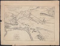
A view of the action gained by the English Sepr. 13 1759 near Quebec.
Description:
Includes inscription to William Pitt from Thos. Jefferys, Insets: Part of the upper river of St. Laurence -- A view of the action gained by the English Sepr. 13 1759 near Quebec, brought from there by an officer of distinction., and Oriented with north to upper
Publisher:
Thos. Jefferys?,
Subject (Geographic):
Saint Lawrence River Estuary (Québec)--History, Military--Maps
Borneo (south west), Sumatra (extreme south), Java (east & west), Sheet H, Borneo (south west), Sumatra (extreme south), Java (east & west), and Sumatra (south), Java (extreme north west)
Description:
Cloth map., Includes notes, index map, and key to abbreviations., Publisher's designations in upper margins: 44/G -- 44/H., Relief shown by contours, gradient tints, and spot heights. Depths shown by soundings., and Sheet H in 3 sections.