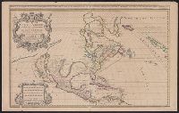
North America divided into its pri[n]cipall parts, viz. Arctick lands, New North Wales, N. South Wales, N. Brittain, Canada, N. Fpance [sic], N. Scotland, N. England, N. York, N. Jarsey, Mary-Land, Virginia, Carolina, Florida, Mexico or N. Spain, N. Mexic
Description:
"Sold by William Berry at the sign of the globe between Charing-Cross and White-Hall, 1680." and Dedication: To the most serene and most sacred majesty of Charles II, by the grace of God, king of Great Brittain, France, and Ireland, this map of North America
Publisher:
William Berry,
Subject (Geographic):
France--Colonies--America--Maps--Early works to 1800, Great Britain--Colonies--America--Maps--Early works to 1800, North America--Maps--Early works to 1800, and Spain--Colonies--America--Maps--Early works to 1800