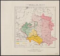
Great Britain. War Office. General Staff. Geographical Section
Published / Created:
1918
Call Number:
11hcf 1919D-3
Container / Volume:
BRBL_00010X
Image Count:
1
Resource Type:
Maps, Atlases & Globes
Alternative Title:
G.S.G.S. ; 3703a and GSGS (Series) ; 3703a.
Description:
Includes chart "Population of certain towns," and index to adjoining maps in series. and Inset map: Density of population.
Publisher:
War Office [G.S.G.S.],
Subject (Topic):
Ethnology--Europe, Central--Maps, Ethnology--Europe, Eastern--Maps, Ethnology--Poland--Maps, Population density--Europe, Central--Maps, Population density--Europe, Eastern--Maps, and Population density--P
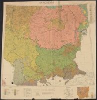
Great Britain. War Office. General Staff. Geographical Section
Published / Created:
1943
Call Number:
38 L562 1943
Container / Volume:
BRBL_00158
Image Count:
1
Resource Type:
Maps, Atlases & Globes
Alternative Title:
France 1:4,000, Geographical Section, General Staff ; no. 4234, and GSGS (Series) ; 4234.
Description:
"2nd edition, 1943.", "6-43.", "Air photographs have been used in the production of this plan.", "Grid provisional, Nord de guerre grid.", "Published by War Office, 1943.", Important streets and buildings are named., and Relief shown by rock drawings.
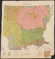
Great Britain. War Office. General Staff. Geographical Section
Published / Created:
1942, 1943 printing.
Call Number:
331gm 1943
Container / Volume:
BRBL_00080
Image Count:
1
Resource Type:
Maps, Atlases & Globes
Alternative Title:
Geographical Section, General Staff ; no. 4183 and GSGS (Series) ; 4183.
Description:
"5-43.", "6/42/G.S.G.S.", "N5047-E402/239x309.", "War Office, 1942.", Five classes of railroads with various traffic facilities, and navigable canals and rivers are shown., and Includes inset maps: Continuation west -- Amsterdam -- Rotterdam -- Antwerp.
Publisher:
Army Map Service, U.S. Army, and War Office ;
Subject (Topic):
Nautical charts--Netherlands, Railroads--Netherlands--Maps, and Waterways--Netherlands--Maps